×
  • Cat-intel
  • MedIntelliX
  • Resources
  • About Us
  • Request Free Sample ×

    Kindly complete the form below to receive a free sample of this Report

    Leading companies partner with us for data-driven Insights

    clients tt-cursor
    Hero Background

    North America Geospatial Imagery Analytics Market

    ID: MRFR/ICT/61016-HCR
    200 Pages
    Aarti Dhapte
    October 2025

    North America Geospatial Imagery Analytics Market Research Report By Analytics type (Video-based Analytics, Imagery Analytics), By Deployment Type (Cloud, On-Premises), By End-User Type (Government, Defense & Security, Engineering & Construction, Mining & Manufacturing, Agriculture, Insurance, Healthcare, Environment Monitoring, Energy, Utility, Natural Resources, Others) and By Regional (US, Canada) - Forecast to 2035

    Share:
    Download PDF ×

    We do not share your information with anyone. However, we may send you emails based on your report interest from time to time. You may contact us at any time to opt-out.

    North America Geospatial Imagery Analytics Market Infographic
    Purchase Options

    North America Geospatial Imagery Analytics Market Summary

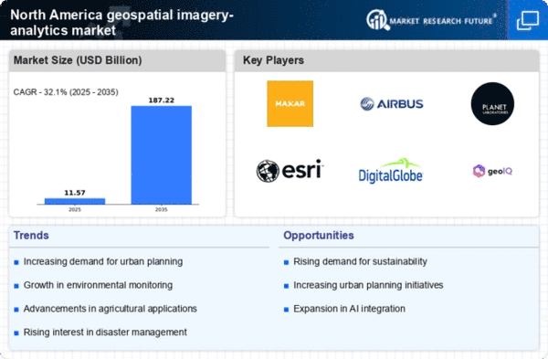
    As per MRFR analysis, the North America geospatial imagery-analytics market size was estimated at 8.76 USD Billion in 2024. The North America geospatial imagery-analytics market is projected to grow from 11.57 USD Billion in 2025 to 187.22 USD Billion by 2035, exhibiting a compound annual growth rate (CAGR) of 32.1% during the forecast period 2025 - 2035.

    Key Market Trends & Highlights

    The North America geospatial imagery-analytics market is poised for substantial growth driven by technological advancements and increasing demand for innovative applications.

    • The integration of AI and Machine Learning is transforming data analysis capabilities in the US, the largest market for geospatial imagery-analytics.
    • Canada emerges as the fastest-growing region, reflecting a surge in government initiatives and investments in geospatial technologies.
    • User-friendly platforms are gaining traction, catering to a broader audience and enhancing accessibility across various sectors.
    • Technological advancements in remote sensing and rising demand for environmental monitoring are key drivers propelling market expansion.

    Market Size & Forecast

    2024 Market Size 8.76 (USD Billion)
    2035 Market Size 187.22 (USD Billion)

    Major Players

    Maxar Technologies (US), Airbus (FR), Planet Labs (US), Esri (US), DigitalGlobe (US), GeoIQ (US), BlackSky (US), Satellogic (AR)

    North America Geospatial Imagery Analytics Market Trends

    The geospatial imagery-analytics market is experiencing notable growth, driven by advancements in technology and increasing demand for data-driven decision-making. In North America, the integration of artificial intelligence and machine learning into geospatial analytics is transforming how organizations interpret and utilize spatial data. This evolution is particularly evident in sectors such as agriculture, urban planning, and environmental monitoring, where precise data analysis is crucial for optimizing resources and enhancing operational efficiency. Furthermore, government initiatives aimed at improving infrastructure and public safety are propelling investments in geospatial technologies, thereby fostering a conducive environment for market expansion. Moreover, the rising awareness of the benefits of geospatial analytics among businesses is likely to contribute to the market's upward trajectory. Organizations are increasingly recognizing the value of location-based insights in enhancing customer experiences and streamlining operations. As a result, there is a growing emphasis on developing user-friendly platforms that facilitate access to geospatial data. This trend is expected to attract a diverse range of stakeholders, including small and medium-sized enterprises, which may further diversify the market landscape. Overall, the geospatial imagery-analytics market in North America appears poised for sustained growth, driven by technological innovation and a shift towards data-centric strategies.

    Integration of AI and Machine Learning

    The incorporation of artificial intelligence and machine learning technologies into geospatial analytics is reshaping the market. These innovations enable more sophisticated data processing and analysis, allowing organizations to derive actionable insights from complex spatial datasets. As a result, sectors such as agriculture and urban planning are increasingly leveraging these technologies to enhance decision-making processes.

    Government Initiatives and Investments

    Government programs aimed at enhancing infrastructure and public safety are significantly influencing the geospatial imagery-analytics market. Increased funding and support for geospatial technologies are fostering innovation and encouraging collaboration among public and private sectors. This trend is likely to lead to the development of advanced applications that improve service delivery and resource management.

    Growing Demand for User-Friendly Platforms

    There is a rising demand for accessible and user-friendly platforms that facilitate the utilization of geospatial analytics. Organizations are seeking solutions that simplify data interpretation and enhance user engagement. This trend is expected to attract a broader audience, including small and medium-sized enterprises, thereby expanding the market's reach and diversity.

    North America Geospatial Imagery Analytics Market Drivers

    Growing Adoption of Cloud-Based Solutions

    The geospatial imagery-analytics market is witnessing a growing adoption of cloud-based solutions, which offer scalability and flexibility for data storage and processing. Organizations are increasingly migrating their geospatial analytics operations to the cloud to take advantage of advanced computing capabilities and cost efficiencies. This shift is particularly relevant for small and medium-sized enterprises that may lack the resources for extensive on-premises infrastructure. The cloud-based segment is expected to account for over 40% of the market share by 2027, driven by the need for real-time data access and collaboration among stakeholders. As more businesses recognize the benefits of cloud technology, the demand for geospatial imagery-analytics solutions is likely to expand.

    Rising Demand for Environmental Monitoring

    The geospatial imagery-analytics market is significantly influenced by the rising demand for environmental monitoring solutions. As climate change concerns escalate, organizations are increasingly utilizing geospatial analytics to track environmental changes, assess natural resources, and manage disaster response. The market for environmental monitoring is expected to reach $5 billion by 2026, reflecting a growing recognition of the importance of data-driven decision-making in sustainability efforts. This trend is further supported by government regulations aimed at promoting environmental protection, which necessitate the use of advanced geospatial technologies for compliance and reporting. Consequently, the demand for sophisticated imagery analytics tools is likely to continue its upward trajectory.

    Technological Advancements in Remote Sensing

    The geospatial imagery-analytics market is experiencing a surge due to rapid technological advancements in remote sensing technologies. Innovations such as high-resolution satellite imagery and aerial drones are enhancing data collection capabilities. For instance, the integration of LiDAR technology allows for precise topographical mapping, which is crucial for urban planning and environmental monitoring. The market is projected to grow at a CAGR of approximately 15% over the next five years, driven by these advancements. Furthermore, the increasing availability of open-source satellite data is enabling more organizations to leverage geospatial analytics, thereby expanding the user base and applications across various sectors, including agriculture, forestry, and disaster management.

    Increased Investment in Smart City Initiatives

    The geospatial imagery-analytics market is benefiting from increased investment in smart city initiatives across North America. Cities are leveraging geospatial analytics to enhance urban planning, optimize resource allocation, and improve public services. For example, the integration of geospatial data into transportation systems can lead to more efficient traffic management and reduced congestion. According to recent estimates, investments in smart city technologies are projected to exceed $100 billion by 2025, creating substantial opportunities for geospatial analytics providers. This trend indicates a shift towards data-driven governance, where real-time geospatial insights play a pivotal role in shaping urban environments and enhancing the quality of life for residents.

    Emerging Applications in Agriculture and Precision Farming

    The geospatial imagery-analytics market is experiencing growth due to emerging applications in agriculture and precision farming. Farmers are increasingly utilizing geospatial analytics to optimize crop yields, monitor soil health, and manage irrigation more effectively. The use of satellite imagery and drones allows for detailed analysis of agricultural fields, enabling data-driven decisions that enhance productivity. The precision agriculture market is projected to reach $12 billion by 2027, indicating a robust demand for geospatial analytics tools tailored to agricultural needs. This trend highlights the potential for geospatial imagery-analytics to transform traditional farming practices into more efficient and sustainable operations.

    Market Segment Insights

    North America Geospatial Imagery Analytics Market Segment Insights

    North America Geospatial Imagery Analytics Market Segment Insights

    Geospatial Imagery Analytics Market Analytics

    Geospatial Imagery Analytics Market Analytics Type Insights

    The North America Geospatial Imagery Analytics Market has witnessed considerable growth, with a significant focus on the Analytics type segment. This market is characterized by its division into two primary categories: Video-based Analytics and Imagery Analytics, both of which play a pivotal role in the overall advancement of the market. Video-based Analytics has emerged as a crucial component, as the need for real-time surveillance and security solutions continues to rise across various sectors.

    The integration of video analytics into geospatial imagery enhances the ability to monitor activities, identify trends, and make informed decisions, especially in urban planning, agriculture, and disaster management. 

    On the other hand, Imagery Analytics gathers substantial attention as it allows for the extraction of actionable insights from satellite and aerial imagery. With the substantial advancements in machine learning and artificial intelligence, Imagery Analytics aids industries in environmental monitoring, resource management, and infrastructure development. This segment supports the need for high-resolution data, enabling stakeholders to visualize complex geographic issues with clarity, thereby fostering better decision-making processes. The convergence of these analytics types is driven by burgeoning applications in smart cities, autonomous vehicles, and environmental monitoring, further propelling the market dynamics.

    Moreover, the increasing availability of modern technologies and sensors fosters opportunities for innovation within the North America Geospatial Imagery Analytics Market. 

    As demand for more sophisticated analytics grows, the capabilities of both Video-based and Imagery Analytics are expected to evolve, enabling enhanced data accuracy and visualization. This will, in turn, support various sectors in deriving meaningful insights and optimizing operational efficiency. Overall, the Analytics type segment stands as a critical driver of growth within the North America Geospatial Imagery Analytics Market, catering to the evolving needs of various industries by providing actionable intelligence from geospatial data.

    Source: Primary Research, Secondary Research, Market Research Future Database and Analyst Review

    Geospatial Imagery Analytics Market Deployment Type Insights

    Geospatial Imagery Analytics Market Deployment Type Insights

    The Deployment Type segment of the North America Geospatial Imagery Analytics Market plays a pivotal role in shaping the industry's growth trajectory. This segment is primarily composed of Cloud and On-Premises models, each catering to different market needs and user preferences. The Cloud deployment is gaining significant traction due to its scalability, cost-effectiveness, and ease of access, allowing users to leverage geospatial imagery analytics without heavy upfront investments in infrastructure. On the other hand, On-Premises solutions offer greater control and security for organizations with strict data compliance requirements.

    As the demand for real-time data processing and analysis continues to rise, both deployment types are expected to evolve, providing enhanced features to meet user expectations. The increasing adoption of advanced technologies, such as artificial intelligence and machine learning in geospatial analytics, further strengthens the relevance of these deployment options. Additionally, regulatory considerations and data protection initiatives in North America drive organizations to carefully choose between Cloud and On-Premises deployments based on their unique operational needs.

    Geospatial Imagery Analytics Market End-User Type Insights

    Geospatial Imagery Analytics Market End-User Type Insights

    The North America Geospatial Imagery Analytics Market is diverse and intricately segmented by End-User Type, reflecting the wide range of applications across various industries. The government sector plays a pivotal role, utilizing geospatial analytics for effective decision-making and resource management. Defense and security applications benefit significantly as well, where precise imagery aids in surveillance and operational strategies. Engineering and construction firms leverage geospatial data for project planning and risk assessment, optimizing project timelines and costs.Mining and manufacturing industries utilize this technology for monitoring resource extraction and managing supply chains more effectively.

    In agriculture, geospatial analytics helps in precision farming by enhancing crop management and yield predictions. 

    The insurance sector employs these insights for risk assessment and loss prevention, while healthcare benefits from innovative spatial data applications for resource allocation and patient management. Environment monitoring is increasingly reliant on geospatial imagery to monitor climate change and natural disasters, providing critical data for remediation efforts.The energy and utility sectors utilize analytics for infrastructure management and optimization of resources. Overall, each segment represents a growing influence of geospatial imagery analytics on operational efficiency and strategic planning in North America.

    Get more detailed insights about North America Geospatial Imagery Analytics Market

    Regional Insights

    US : Leading Market Share and Innovation

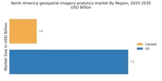
    The US holds a commanding market share of 7.12 in the geospatial imagery-analytics sector, driven by robust demand for advanced analytics in sectors like agriculture, defense, and urban planning. Key growth drivers include government initiatives promoting smart city projects and investments in satellite technology. Regulatory frameworks support data sharing and innovation, while significant infrastructure development enhances data accessibility and processing capabilities.

    Canada : Growing Demand and Investment Opportunities

    Canada's geospatial imagery-analytics market is valued at 1.64, reflecting a growing interest in environmental monitoring and resource management. Key growth drivers include increasing investments in renewable energy and urban development projects. The Canadian government supports innovation through funding programs and partnerships with tech firms, fostering a conducive environment for market expansion.

    Key Players and Competitive Insights

    The geospatial imagery-analytics market is currently characterized by a dynamic competitive landscape, driven by advancements in technology and increasing demand for data-driven insights across various sectors. Key players such as Maxar Technologies (US), Planet Labs (US), and Esri (US) are at the forefront, each adopting distinct strategies to enhance their market positioning. Maxar Technologies (US) focuses on innovation through the development of high-resolution satellite imagery, while Planet Labs (US) emphasizes rapid data acquisition and analysis capabilities. Esri (US), on the other hand, leverages its robust GIS software to integrate geospatial data into broader analytical frameworks, thereby enhancing decision-making processes for its clients. Collectively, these strategies contribute to a competitive environment that is increasingly reliant on technological advancements and data integration.

    In terms of business tactics, companies are increasingly localizing their operations to better serve regional markets and optimize supply chains. The market structure appears moderately fragmented, with several players vying for dominance while also collaborating through partnerships and alliances. This collective influence of key players fosters a competitive atmosphere where innovation and responsiveness to market needs are paramount.

    In October 2025, Maxar Technologies (US) announced a strategic partnership with a leading AI firm to enhance its satellite imagery analysis capabilities. This collaboration is expected to significantly improve the accuracy and speed of data processing, allowing clients to derive actionable insights more efficiently. Such a move underscores Maxar's commitment to integrating cutting-edge technology into its offerings, positioning it favorably against competitors.

    In September 2025, Planet Labs (US) launched a new satellite constellation aimed at providing near-real-time imagery for environmental monitoring. This initiative not only expands its service portfolio but also aligns with growing global concerns regarding climate change. By offering timely data, Planet Labs (US) enhances its value proposition to clients in sectors such as agriculture and urban planning, thereby solidifying its market presence.

    In August 2025, Esri (US) unveiled an upgraded version of its ArcGIS platform, incorporating advanced machine learning algorithms to facilitate deeper data analysis. This enhancement is likely to attract a broader client base, as organizations increasingly seek sophisticated tools for geospatial analytics. Esri's focus on continuous improvement and user-centric design reflects its strategic intent to maintain leadership in the geospatial analytics domain.

    As of November 2025, current trends in the geospatial imagery-analytics market are heavily influenced by digitalization, sustainability initiatives, and the integration of AI technologies. Strategic alliances are becoming increasingly vital, as companies recognize the need to pool resources and expertise to remain competitive. Looking ahead, it appears that competitive differentiation will evolve from traditional price-based strategies to a focus on innovation, technological advancements, and supply chain reliability. This shift suggests that companies that prioritize these areas are likely to thrive in an increasingly complex market.

    Key Companies in the North America Geospatial Imagery Analytics Market market include

    Industry Developments

    The North America Geospatial Imagery Analytics Market has witnessed significant developments recently. In September 2023, Maxar Technologies announced a partnership with Esri to integrate geospatial data for enhanced mapping solutions, aiming to leverage both companies' strengths in analytics and visualization. In August 2023, Planet Labs secured a contract with NASA for satellite imagery services, highlighting the growing demand for high-resolution geospatial data in scientific research. Moreover, Google and L3Harris Technologies collaborated to provide geospatial solutions for urban planning and infrastructure development in various municipalities across the United States. 

    The market has seen notable growth, with the valuation of companies like Science Applications International Corporation increasing due to expanded contract acquisitions with government agencies. Furthermore, in June 2022, DigitalGlobe's acquisition by Maxar Technologies was finalized, enhancing Maxar's portfolio and capabilities in Earth observation. The combination of these strategic partnerships, acquisitions, and increasing demand for geospatial services among governmental and industrial sectors underlines the vibrant nature of the North America Geospatial Imagery Analytics Market.

    Future Outlook

    North America Geospatial Imagery Analytics Market Future Outlook

    The geospatial imagery-analytics market is projected to grow at a 32.1% CAGR from 2024 to 2035, driven by advancements in AI, increased demand for real-time data, and enhanced satellite technologies.

    New opportunities lie in:

    • Development of AI-driven predictive analytics tools for urban planning.
    • Integration of geospatial data with IoT for smart agriculture solutions.
    • Expansion of subscription-based models for continuous imagery access.

    By 2035, the market is expected to achieve substantial growth, driven by innovative applications and technological advancements.

    Market Segmentation

    North America Geospatial Imagery Analytics Market End-User Type Outlook

    • Government
    • Defense & Security
    • Engineering & Construction
    • Mining & Manufacturing
    • Agriculture
    • Insurance
    • Healthcare
    • Environment Monitoring
    • Energy, Utility, and Natural Resources
    • Others

    North America Geospatial Imagery Analytics Market Analytics Type Outlook

    • Video-Based Analytics
    • Imagery Analytics

    North America Geospatial Imagery Analytics Market Deployment Type Outlook

    • Cloud
    • On-Premises

    Report Scope

    MARKET SIZE 20248.76(USD Billion)
    MARKET SIZE 202511.57(USD Billion)
    MARKET SIZE 2035187.22(USD Billion)
    COMPOUND ANNUAL GROWTH RATE (CAGR)32.1% (2024 - 2035)
    REPORT COVERAGERevenue Forecast, Competitive Landscape, Growth Factors, and Trends
    BASE YEAR2024
    Market Forecast Period2025 - 2035
    Historical Data2019 - 2024
    Market Forecast UnitsUSD Billion
    Key Companies Profiled["Maxar Technologies (US)", "Airbus (FR)", "Planet Labs (US)", "Esri (US)", "DigitalGlobe (US)", "GeoIQ (US)", "BlackSky (US)", "Satellogic (AR)"]
    Segments CoveredAnalytics Type, Deployment Type, End-User Type
    Key Market OpportunitiesIntegration of artificial intelligence enhances predictive analytics in the geospatial imagery-analytics market.
    Key Market DynamicsTechnological advancements drive competitive dynamics in the geospatial imagery-analytics market, enhancing data accuracy and accessibility.
    Countries CoveredUS, Canada

    Leave a Comment

    FAQs

    What is the expected market size of the North America Geospatial Imagery Analytics Market in 2024?

    The North America Geospatial Imagery Analytics Market is expected to be valued at 7.5 billion USD in 2024.

    What is the projected market size for the North America Geospatial Imagery Analytics Market by 2035?

    By 2035, the market is projected to reach a value of 63.6 billion USD.

    What is the expected CAGR for the North America Geospatial Imagery Analytics Market from 2025 to 2035?

    The market is expected to grow at a CAGR of 21.451% during the forecast period from 2025 to 2035.

    What is the anticipated market value for Video-based Analytics in 2024?

    In 2024, the Video-based Analytics segment is anticipated to be valued at 2.0 billion USD.

    What will be the market size for Imagery Analytics in 2035?

    By 2035, the Imagery Analytics segment is projected to reach a value of 47.0 billion USD.

    Which region holds the majority market share in the North America Geospatial Imagery Analytics Market?

    The US holds the majority market share, projected to be valued at 4.5 billion USD in 2024.

    What is the market size for Canada in the North America Geospatial Imagery Analytics Market in 2024?

    Canada's market size is projected to be 3.0 billion USD in 2024.

    Who are the major players in the North America Geospatial Imagery Analytics Market?

    Major players include Geosys, Science Applications International Corporation, DigitalGlobe, L3Harris Technologies, and Google.

    What are the expected market values for the US and Canada in 2035?

    In 2035, the US market is expected to reach 38.0 billion USD, while the Canadian market is projected at 25.6 billion USD.

    What is a key emerging trend in the North America Geospatial Imagery Analytics Market?

    There is a significant trend towards integrating advanced analytics and AI technologies into geospatial imagery analytics.

    Download Free Sample

    Kindly complete the form below to receive a free sample of this Report

    Case Study
    Chemicals and Materials

    Compare Licence

    ×
    Features License Type
    Single User Multiuser License Enterprise User
    Price $4,950 $5,950 $7,250
    Maximum User Access Limit 1 User Upto 10 Users Unrestricted Access Throughout the Organization
    Free Customization
    Direct Access to Analyst
    Deliverable Format
    Platform Access
    Discount on Next Purchase 10% 15% 15%
    Printable Versions