Growing Adoption of Smart City Initiatives
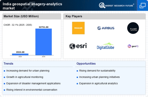
The push towards smart city initiatives in India serves as a significant driver for the geospatial imagery-analytics market. These initiatives aim to enhance urban living through technology integration, requiring comprehensive data analysis for effective implementation. Geospatial analytics plays a vital role in optimizing urban services, traffic management, and resource allocation. The Indian government has allocated substantial funding for smart city projects, with an estimated budget of over $1.5 billion for the Smart Cities Mission. This financial commitment is likely to spur demand for geospatial analytics solutions, as cities seek to leverage data for improved governance and citizen engagement. The market is poised for growth as stakeholders recognize the potential of geospatial technologies in transforming urban landscapes.
Agricultural Optimization and Precision Farming
Agriculture remains a cornerstone of the Indian economy, contributing approximately 18% to the GDP. The geospatial imagery-analytics market is significantly influenced by the need for agricultural optimization. Farmers and agribusinesses are increasingly adopting precision farming techniques, which rely on geospatial data to enhance crop yields and resource efficiency. By utilizing satellite imagery and analytics, stakeholders can monitor crop health, soil conditions, and weather patterns. This data-driven approach not only improves productivity but also aids in sustainable practices, aligning with government initiatives for food security. The market for geospatial imagery analytics in agriculture is projected to grow as more farmers recognize the benefits of integrating technology into their operations.
Environmental Monitoring and Disaster Management
India's diverse geography and susceptibility to natural disasters underscore the importance of environmental monitoring, a key driver for the geospatial imagery-analytics market. The ability to analyze land use changes, deforestation, and climate impacts is vital for sustainable development. Geospatial analytics enables authorities to assess risks and implement effective disaster management strategies. For instance, satellite imagery can be utilized to monitor flood-prone areas, allowing for timely interventions. The Indian government has invested in satellite technology to enhance disaster response capabilities, which is likely to further stimulate demand for geospatial analytics solutions. As environmental concerns grow, the market is expected to expand, driven by the need for comprehensive monitoring and management tools.
Rising Urbanization and Infrastructure Development
Rapid urbanization in India is a crucial driver for the geospatial imagery-analytics market. As cities expand, the need for effective urban planning and infrastructure management becomes paramount. Geospatial imagery provides valuable insights into land use, transportation networks, and resource allocation. According to recent estimates, urban areas in India are expected to house over 600 million people by 2031, necessitating advanced analytics to manage urban sprawl. This growth creates a demand for precise geospatial data to inform decision-making processes in urban development. Consequently, stakeholders in the geospatial imagery-analytics market are likely to experience increased opportunities as municipalities and private developers seek to leverage these technologies for sustainable urban growth.
Advancements in Satellite Technology and Data Accessibility
The evolution of satellite technology has significantly impacted the geospatial imagery-analytics market in India. With the launch of new satellites and improved imaging capabilities, access to high-resolution data has become more widespread. This advancement allows for more accurate and timely analysis across various sectors, including urban planning, agriculture, and environmental monitoring. The Indian Space Research Organisation (ISRO) has been pivotal in enhancing satellite data availability, which is likely to drive market growth. As organizations increasingly rely on satellite imagery for decision-making, the demand for analytics tools that can process and interpret this data is expected to rise, fostering innovation within the geospatial imagery-analytics market.


