China Geospatial Imagery Analytics Market Overview
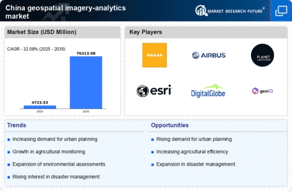
As per MRFR analysis, the China Geospatial Imagery Analytics Market Size was estimated at 2.71 (USD Billion) in 2023. The China Geospatial Imagery Analytics Market Industry is expected to grow from 3.1(USD Billion) in 2024 to 29.5 (USD Billion) by 2035. The China Geospatial Imagery Analytics Market CAGR (growth rate) is expected to be around 22.73% during the forecast period (2025 - 2035)
Key China Geospatial Imagery Analytics Market Trends Highlighted
The China geospatial imagery analytics market is expanding significantly due to a number of important factors. Accurate and high-resolution geospatial data is becoming more and more necessary for infrastructure construction, environmental monitoring, and urban planning. Because of the Chinese government's emphasis on smart city programs, there is an urgent need for sophisticated geospatial analytics to aid in decision-making. Furthermore, the region's adoption of geospatial imaging analytics has been accelerated by the increased emphasis on disaster management and response planning brought about by the surge in natural disasters.Â
In this market, there are opportunities to investigate, such as combining geospatial analytics with machine learning and artificial intelligence. Public safety, transportation, and agriculture are just a few of the industries that stand to gain from this technology's deeper insights and improved data analytic capabilities. Additionally, businesses have the chance to provide cutting-edge geospatial solutions suited to a range of industries thanks to the Chinese government's push for digital transformation and investments in satellite technology. Drone technology is being used more and more, according to recent developments in the China geospatial imaging analytics market.Â
High-resolution photographs are being captured by drones more frequently for a variety of uses, including environmental monitoring and land surveying. The development of geographic databases by the public and corporate sectors, which facilitates resource management and regulatory compliance, is another trend. The use of geospatial analytics for initiatives aiming at lowering carbon footprints and promoting sustainable practices is also being encouraged by China's growing emphasis on sustainability and environmental protection. All things considered, China's geospatial imagery analytics scene is growing more dynamic and diverse due to both government programs and technology advancements.

Source: Primary Research, Secondary Research, MRFR Database and Analyst Review
China Geospatial Imagery Analytics Market Drivers
Increasing Government Investments in Smart City Initiatives
The rapid urbanization in China is pushing the government to invest significantly in smart city initiatives, which heavily rely on Geospatial Imagery Analytics for urban planning and management. The Ministry of Housing and Urban-Rural Development of China has reported a commitment to invest over 1 trillion Yuan (approximately 150 billion USD) in smart city projects by 2025. Such investments are expected to enhance infrastructure, optimize resource management, and improve the quality of urban life, propelling the demand for the China Geospatial Imagery Analytics Market Industry.
Companies like China National Geographic Information Bureau are also involved in creating foundational frameworks to support this expansion, further driving analytics use in urban landscapes. This substantial funding towards innovative technologies showcases the increasing reliance on geospatial data analytics in national development strategies.
Growth of Agricultural Technologies
China's agriculture sector is embracing technology to enhance productivity and resource management, and Geospatial Imagery Analytics plays a critical role in this transformation. The Chinese government reported that agricultural productivity could increase by 30% through precision agriculture practices enabled by geospatial technology. This trend is supported by the Ministry of Agriculture and Rural Affairs' data, which indicated that farmers utilizing precision farming technologies rose by 25% in the last three years.
Countless companies, including major agricultural firms, are now incorporating aerial imagery and analytics into crop management, forecasting, and soil health monitoring, creating a burgeoning space for the China Geospatial Imagery Analytics Market Industry.
Need for Disaster Management and Monitoring
China faces numerous natural disasters annually, necessitating advanced monitoring and management systems. The National Disaster Reduction Center of China reports that economic losses from disasters have reached approximately 150 billion Yuan (around 22 billion USD) annually. To mitigate these losses, the government is increasingly leveraging Geospatial Imagery Analytics to improve disaster preparedness and response capabilities.Â
Organizations such as the Chinese Academy of Sciences have pioneered programs utilizing satellite imagery for real-time disaster impact assessments.The emphasis on geospatial technology in disaster management provides a strong growth driver for the China Geospatial Imagery Analytics Market Industry, reinforcing a need for better resilience strategies.
Expansion of Infrastructure Development Projects
Infrastructure development in China is undergoing a massive expansion, with the government planning to invest over 12 trillion Yuan (approximately 1.8 trillion USD) in transport infrastructure by 2030. These developments necessitate the use of Geospatial Imagery Analytics for planning and implementation purposes. The Ministry of Transport of the People's Republic of China underscored the importance of leveraging geospatial technologies to enhance project feasibility studies, environmental impact assessments, and logistics.
Companies such as China Railway Corporation are actively utilizing geospatial data to drive their developments. This surge in infrastructure projects directly correlates with the growth forecast for the China Geospatial Imagery Analytics Market Industry, as these projects increasingly rely on spatial data for enhanced operational efficiencies.
China Geospatial Imagery Analytics Market Segment Insights
Geospatial Imagery Analytics Market Analytics type Insights
The China Geospatial Imagery Analytics Market is experiencing substantial evolution within the Analytics type segment, which is crucial for enhancing decision-making processes across various industries. Among the two primary categories, Video-based Analytics has emerged as a transformative force, significantly impacting sectors such as transportation, urban planning, and security. Video-based Analytics leverages real-time data streaming to provide insights on traffic patterns, crowd behavior, and potential security threats, making it vital for governmental and commercial applications. This segment benefits from advancements in artificial intelligence and machine learning, allowing for more accurate analysis and predictions, thus driving its demand in urban environments across China.On the other hand, Imagery Analytics plays an indispensable role by harnessing high-resolution satellite imagery, drone data, and aerial photography.Â
This aspect is essential for applications in agriculture, environmental monitoring, land development, and disaster response. Particularly in a rapidly urbanizing nation like China, Imagery Analytics enables stakeholders to monitor land-use changes, crop health, and natural resource management. It facilitates effective spatial planning and resource allocation, thus contributing significantly to sustainable development goals. Additionally, as organizations increasingly recognize the value of location-based analytics, the demand for both Video-based and Imagery Analytics continues to accelerate, highlighting their crucial roles in improving productivity and innovation within the Chinese market landscape. As cities grow and data becomes more abundant, these analytical types are poised to dominate the landscape, reflecting the growing interest in leveraging geospatial data for actionable insights.Â
In light of the rising trend of smart city initiatives in China, both Video-based and Imagery Analytics are becoming increasingly prominent, with government policies emphasizing the integration of advanced technologies into urban management systems. This supports the shift towards more intelligent infrastructure development and efficient resource management, which is vital for addressing the challenges posed by rapid urbanization. As such, the Analytics type segment stands at the forefront of the overarching China Geospatial Imagery Analytics Market, with both categories reinforcing each other as they address the pressing needs of a dynamic economy.

Source: Primary Research, Secondary Research, MRFR Database and Analyst Review
Geospatial Imagery Analytics Market Deployment Type Insights
The Deployment Type segment of the China Geospatial Imagery Analytics Market plays a crucial role in shaping the overall landscape of geospatial technologies. This segment primarily consists of Cloud and On-Premises options, each catering to different needs and preferences within the market. The Cloud deployment model is gaining significant traction due to its scalability, cost-effectiveness, and ease of access, making it appealing for organizations aiming to leverage geospatial data without extensive infrastructure investment. Conversely, the On-Premises model is favored by enterprises that prioritize data security and control, often opting for this setup to meet compliance and regulatory requirements.
The ongoing digital transformation in China is driving adoption across these platforms, as companies increasingly recognize the value of integrating geospatial analytics into their operations. This transition also aligns with government initiatives promoting smart city development and urban planning, further bolstering the importance of geospatial imagery analytics in enhancing decision-making processes. The diverse needs of various sectors, such as agriculture, environmental monitoring, and urban management, underscore the significance of both Cloud and On-Premises deployment types in the evolving landscape of the China Geospatial Imagery Analytics Market.
Geospatial Imagery Analytics Market End-User Type Insights
The China Geospatial Imagery Analytics Market exhibits significant dynamism across various End-User Types, reflecting the intricate needs of different sectors. The Government segment stands out as a key driver, leveraging geospatial data for urban planning and policy-making. Defense and Security utilize this technology for surveillance and intelligence gathering, enhancing national security measures. In Engineering and Construction, analytics play a critical role in project management and site evaluation, improving efficiency. The Mining and Manufacturing sectors benefit from geospatial insights to optimize resource extraction and streamline operations.Agriculture is increasingly adopting geospatial analytics for precision farming, enabling better crop management and yield predictions.Â
In Insurance, companies use geospatial data to assess risks and streamline claims processes. The Healthcare segment employs geospatial tools for spatial analysis in epidemiology and public health initiatives. Environment Monitoring relies on geospatial imagery for tracking climate change and natural resource management. Energy and Utility firms harness analytics for infrastructure management and outage prediction.As various industries in China recognize the vast potential of geospatial imagery analytics, this segment is expected to show substantial growth, driven by advancements in technologies and increasing data integration efforts across markets.
China Geospatial Imagery Analytics Market Key Players and Competitive Insights
The competitive landscape of the China Geospatial Imagery Analytics Market has been shaped by various factors including technological advancements and the increasing demand for detailed geographical data. As businesses and governments seek to leverage geospatial information for decision-making processes, the market has attracted both local and international players striving to establish their dominance. The market's competitive insights reveal a dynamic environment where companies are engaged in continuous innovation to enhance their offerings. Factors such as the integration of artificial intelligence and machine learning into imagery analytics are critical in determining the competitive advantage of market participants.Â
Furthermore, collaborations and strategic partnerships play a significant role in enhancing capabilities and expanding market reach, providing companies with opportunities to capitalize on the growing demand for geospatial data analytics in various sectors, including urban planning, environmental monitoring, and disaster management.In the context of the China Geospatial Imagery Analytics Market, DigitalGlobe has solidified its position as a leading provider of high-resolution satellite imagery. The company benefits from its robust technology framework, which allows for precise imagery capture and analysis that meets the rigorous demands of the market. DigitalGlobe's strengths lie in its vast repository of satellite data and its capacity to deliver customized solutions that cater to specific client needs. It has successfully established partnerships with government agencies and commercial entities, enhancing its market presence in China.Â
By continually investing in advanced satellite technology and analytics software, DigitalGlobe has maintained a competitive edge, positioning itself as a reliable source for accurate geospatial information which is crucial for numerous applications ranging from urban development to agricultural monitoring.China National Environmental Monitoring Center operates within the China Geospatial Imagery Analytics Market with a focus on environmental monitoring and management. This organization plays a pivotal role in the collection, analysis, and dissemination of geospatial data related to environmental conditions across China. The center's strengths include its access to extensive government funding and its ability to utilize nationwide environmental policies to enhance its capabilities in geospatial analytics. It offers various key services, including pollutant tracking, land use assessment, and disaster response analytics, thus cementing its relevance in the market.Â
Moreover, China National Environmental Monitoring Center is involved in ongoing efforts to modernize its technological infrastructure, facilitating improved data collection and processing techniques. The center’s strategic focus yields an enhanced ability to address pressing environmental issues and provides a critical contribution to national initiatives aimed at sustainable development. With potentially significant growth through collaborations with technological firms, the center remains integral to China's geospatial imagery analytics landscape.
Key Companies in the China Geospatial Imagery Analytics Market Include
- DigitalGlobe
- China National Environmental Monitoring Center
- China GeoEngineering Corporation
- SinoMap
- Beijing Huayuan Digital Technology
- Nanjing University of Information Science and Technology
- Eagle Technology
- China Aerospace Science and Technology Corporation
- China Satellite Navigation Office
- Alibaba
- HongHua Group
- Mapbar
- Tencent
- GeoDragon
- Baidu
China Geospatial Imagery Analytics Market Industry Developments
In recent months, the China Geospatial Imagery Analytics Market has seen significant developments as key players such as China National Environmental Monitoring Center and China Aerospace Science and Technology Corporation expand their satellite capabilities to enhance environmental monitoring and urban planning. In October 2023, Alibaba announced a partnership with Beijing Huayuan Digital Technology to develop AI-driven analytics tools for urban planning, reinforcing the trend of integrating artificial intelligence in geospatial analysis. Furthermore, in August 2023, Tencent invested in a start-up specializing in drone-based imagery, hinting at a push towards unmanned aerial vehicle technologies within the sector.Â
In terms of mergers and acquisitions, the China GeoEngineering Corporation acquired Eagle Technology in July 2023, enhancing its geospatial capabilities and expanding its service portfolio. The market has experienced a robust growth trajectory, with valuations of major firms like DigitalGlobe and SinoMap witnessing upward trends due to increasing demand for precision agriculture and infrastructural development. Over the last few years, significant investments have been reported in technologies such as geospatial data analytics, with a notable mention of government initiatives aimed at boosting the use of geospatial information for sustainable development objectives as outlined in the national 14th Five-Year Plan.
China Geospatial Imagery Analytics Market Segmentation Insights
Geospatial Imagery Analytics Market Analytics type Outlook
- Video-based Analytics
- Imagery Analytics
Geospatial Imagery Analytics Market Deployment Type Outlook
Geospatial Imagery Analytics Market End-User Type Outlook
- Government
- Defense & Security
- Engineering & Construction
- Mining & Manufacturing
- Agriculture
- Insurance
- Healthcare
- Environment Monitoring
- Energy
- Utility
- Natural Resources
- Others
Â
Report Attribute/Metric Source: |
Details |
MARKET SIZE 2023 |
2.71(USD Billion) |
MARKET SIZE 2024 |
3.1(USD Billion) |
MARKET SIZE 2035 |
29.5(USD Billion) |
COMPOUND ANNUAL GROWTH RATE (CAGR) |
22.73% (2025 - 2035) |
REPORT COVERAGE |
Revenue Forecast, Competitive Landscape, Growth Factors, and Trends |
BASE YEAR |
2024 |
MARKET FORECAST PERIOD |
2025 - 2035 |
HISTORICAL DATA |
2019 - 2024 |
MARKET FORECAST UNITS |
USD Billion |
KEY COMPANIES PROFILED |
DigitalGlobe, China National Environmental Monitoring Center, China GeoEngineering Corporation, SinoMap, Beijing Huayuan Digital Technology, Nanjing University of Information Science and Technology, Eagle Technology, China Aerospace Science and Technology Corporation, China Satellite Navigation Office, Alibaba, HongHua Group, Mapbar, Tencent, GeoDragon, Baidu |
SEGMENTS COVERED |
Analytics type, Deployment Type, End-User Type |
KEY MARKET OPPORTUNITIES |
Urban planning enhancement, Disaster management solutions, Agriculture optimization tools, Environmental monitoring applications, Transportation infrastructure analytics |
KEY MARKET DYNAMICS |
Government investments in infrastructure, Increasing demand for urban planning, Growing environmental monitoring needs, Advancements in AI technologies, Rising applications in agriculture |
COUNTRIES COVERED |
China |
Frequently Asked Questions (FAQ):
The market is projected to reach a valuation of 3.1 billion USD in 2024.
By 2035, the market is expected to be valued at 29.5 billion USD.
The market is anticipated to grow at a CAGR of 22.73% during the forecast period from 2025 to 2035.
In 2024, the Video-based Analytics segment is valued at 1.5 billion USD, indicating a substantial share in the market.
By 2035, the Imagery Analytics segment is projected to reach a market size of 15.0 billion USD.
Major players include DigitalGlobe, China National Environmental Monitoring Center, and Alibaba among others.
The increasing demand for accurate geospatial data and advancements in technology present significant growth opportunities.
Key applications include urban planning, environmental monitoring, and disaster management.
Both Video-based and Imagery Analytics segments are expected to experience significant growth, with Video-based growing from 1.5 billion USD in 2024 to 14.5 billion USD by 2035.
Challenges include data privacy concerns and the integration of various technologies for comprehensive analytics.