Increased Investment in Smart Agriculture
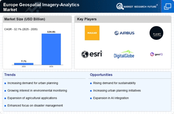
The agricultural sector in Europe is increasingly adopting geospatial imagery-analytics to enhance productivity and sustainability. Smart agriculture practices, which leverage geospatial data for precision farming, are gaining traction among farmers. This trend is driven by the need to optimize resource use, reduce waste, and improve crop yields. The European Commission has recognized the potential of digital technologies in agriculture, allocating substantial funding to support research and development in this area. As a result, the geospatial imagery-analytics market is likely to expand, with projections indicating a growth rate of around 12% annually as more farmers embrace data-driven decision-making.
Growing Demand for Urban Planning Solutions
Urbanization in Europe is accelerating, leading to a heightened demand for effective urban planning solutions. The geospatial imagery-analytics market is responding to this need by providing tools that facilitate better land use, infrastructure development, and resource management. Cities are increasingly utilizing geospatial analytics to optimize transportation networks and public services. According to recent studies, urban areas are expected to account for over 80% of the European population by 2050, necessitating advanced analytics to manage urban growth sustainably. This trend is likely to propel the market forward, as municipalities seek innovative solutions to address the challenges posed by rapid urbanization.
Rising Importance of Environmental Monitoring
Environmental monitoring is becoming increasingly critical in Europe, driving demand for geospatial imagery-analytics solutions. The need to track changes in land use, biodiversity, and climate impacts is prompting governments and organizations to invest in advanced analytics. The European Environment Agency has emphasized the role of geospatial data in assessing environmental conditions and informing policy decisions. This focus on sustainability is likely to propel the market forward, as stakeholders seek to leverage geospatial analytics for effective environmental management. The market is expected to witness a growth trajectory of approximately 10% over the next few years, reflecting the rising importance of environmental stewardship.
Technological Advancements in Satellite Imagery
The geospatial imagery-analytics market in Europe is experiencing a surge. This growth is due to rapid technological advancements in satellite imagery.. Enhanced resolution and improved data capture capabilities are enabling more precise analytics. For instance, the integration of synthetic aperture radar (SAR) technology has allowed for all-weather imaging, which is crucial for various applications such as agriculture and urban planning. The European Space Agency (ESA) has been pivotal in this evolution, investing heavily in satellite missions that provide high-quality data. As a result, the market is projected to grow at a CAGR of approximately 15% over the next five years, driven by the increasing demand for accurate geospatial data across multiple sectors.
Integration of Geospatial Data in Disaster Management
The geospatial imagery-analytics market in Europe is significantly influenced by the integration of geospatial data in disaster management strategies. With climate change leading to more frequent and severe weather events, the need for effective disaster response mechanisms has become paramount. Geospatial analytics provides critical insights for risk assessment, emergency response planning, and recovery efforts. For example, the European Union has implemented various initiatives to enhance disaster resilience, utilizing geospatial data to inform decision-making processes. This focus on disaster management is expected to drive market growth, as governments and organizations invest in technologies that improve situational awareness and response capabilities.


