Growing Environmental Awareness
The Satellite Photogrammetry Software Market is significantly influenced by the growing awareness of environmental issues. As concerns regarding climate change and natural resource management intensify, there is a heightened demand for tools that can provide accurate environmental monitoring. Satellite photogrammetry software enables users to assess land use changes, monitor deforestation, and analyze the impacts of climate change effectively. Recent studies indicate that the market for environmental monitoring solutions is expanding, with a substantial portion attributed to advancements in satellite technology. This trend suggests that the Satellite Photogrammetry Software Market is likely to see increased adoption of its solutions in environmental applications, as organizations seek to leverage data for sustainable practices and informed decision-making.
Rising Demand for Geospatial Data
The Satellite Photogrammetry Software Market is witnessing a notable increase in demand for geospatial data across multiple sectors. Industries such as agriculture, construction, and environmental management are increasingly relying on accurate spatial information for decision-making processes. The need for precise mapping solutions is becoming more pronounced, as organizations seek to optimize resource allocation and improve operational efficiency. Recent statistics indicate that the demand for geospatial data is expected to grow significantly, with a projected market value reaching several billion dollars by 2026. This trend is likely to propel the Satellite Photogrammetry Software Market forward, as software solutions become essential tools for data analysis and visualization. Consequently, companies that provide innovative photogrammetry solutions are well-positioned to capitalize on this growing demand.
Government Initiatives and Funding
Government initiatives and funding play a crucial role in the Satellite Photogrammetry Software Market. Various governments are increasingly investing in satellite technology and geospatial data infrastructure to enhance national security, disaster management, and urban planning. For instance, funding programs aimed at developing satellite capabilities are likely to stimulate growth in the photogrammetry software sector. Recent reports suggest that government spending on satellite technology is expected to increase, with allocations reaching billions of dollars in the coming years. This financial support not only fosters innovation but also encourages collaboration between public and private sectors, thereby enhancing the overall capabilities of the Satellite Photogrammetry Software Market. As a result, companies involved in this market may benefit from increased opportunities and resources.
Increased Adoption in Various Industries
The Satellite Photogrammetry Software Market is experiencing increased adoption across a diverse range of industries. Sectors such as agriculture, mining, and urban planning are recognizing the value of satellite imagery and photogrammetry for enhancing operational efficiency and decision-making. The ability to generate high-resolution maps and 3D models is becoming indispensable for businesses aiming to optimize their processes. Recent market analyses indicate that the adoption rate of satellite photogrammetry solutions is on the rise, with many companies integrating these technologies into their workflows. This trend is likely to continue, as industries seek innovative ways to leverage spatial data for competitive advantage. Consequently, the Satellite Photogrammetry Software Market stands to benefit from this growing trend, as more organizations invest in advanced photogrammetry solutions.
Technological Advancements in Satellite Photogrammetry Software
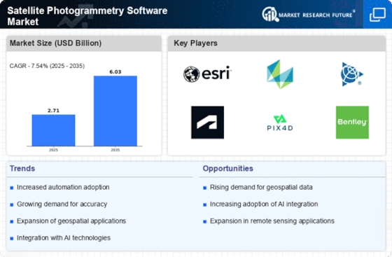
The Satellite Photogrammetry Software Market is experiencing a surge in demand due to rapid technological advancements. Innovations in artificial intelligence and machine learning are enhancing the capabilities of photogrammetry software, allowing for more accurate and efficient data processing. The integration of high-resolution satellite imagery with advanced algorithms is enabling users to extract detailed geographical information. According to recent data, the market is projected to grow at a compound annual growth rate of approximately 15% over the next five years. This growth is driven by the increasing need for precise mapping and modeling in various sectors, including urban planning, agriculture, and environmental monitoring. As technology continues to evolve, the Satellite Photogrammetry Software Market is likely to witness further enhancements, making it an attractive area for investment and development.


