info@marketresearchfuture.com   📞 +1 (855) 661-4441(US)   📞 +44 1720 412 167(UK)   📞 +91 2269738890(APAC)
Certified Global Research Member
Isomar 1 Iso 1
Key Questions Answered
  • Global Market Outlook
  • In-depth analysis of global and regional trends
  • Analyze and identify the major players in the market, their market share, key developments, etc.
  • To understand the capability of the major players based on products offered, financials, and strategies.
  • Identify disrupting products, companies, and trends.
  • To identify opportunities in the market.
  • Analyze the key challenges in the market.
  • Analyze the regional penetration of players, products, and services in the market.
  • Comparison of major players financial performance.
  • Evaluate strategies adopted by major players.
  • Recommendations
Why Choose Market Research Future?
  • Vigorous research methodologies for specific market.
  • Knowledge partners across the globe
  • Large network of partner consultants.
  • Ever-increasing/ Escalating data base with quarterly monitoring of various markets
  • Trusted by fortune 500 companies/startups/ universities/organizations
  • Large database of 5000+ markets reports.
  • Effective and prompt pre- and post-sales support.

Germany Photogrammetry Software Market Research Report By Photogrammetry Type (Aerial Photogrammetry, Terrestrial Photogrammetry, Close-Range Photogrammetry, Satellite Photogrammetry, Underwater Photogrammetry, Others), By Deployment Mode (On-premises, Cloud-based), By Pricing Model (Commercial/Proprietary Software, Open-Source Software), and By End Use Vertical (Architecture, Engineering, Construction (AEC), Surveying and Mapping, Mining and Natural Resources, Oil and Gas, Agriculture and Forestry, Cultural Heritage and Archaeology, Defens


ID: MRFR/ICT/60061-HCR | 200 Pages | Author: Aarti Dhapte| August 2025

Germany Photogrammetry Software Market Overview

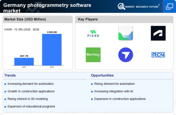
As per MRFR analysis, the Germany Photogrammetry Software Market Size was estimated at 196.7 (USD Million) in 2023.The Germany Photogrammetry Software Market is expected to grow from 250(USD Million) in 2024 to 1,450 (USD Million) by 2035. The Germany Photogrammetry Software Market CAGR (growth rate) is expected to be around 17.328% during the forecast period (2025 - 2035).

Key Germany Photogrammetry Software Market Trends Highlighted

Technological developments in the collection and processing of visual data are driving a considerable evolution in the German photogrammetry software market. The growing need for accurate surveying and mapping solutions across a range of industries, including urban planning, agriculture, and construction, is one of the main factors propelling the market.

Organizations are using photogrammetry solutions into their operations to increase accuracy and efficiency as a result of these sectors' push towards digitalization. Additionally, the adoption of photogrammetry software is being fueled by the German government's significant investments in smart city projects, which call for the use of cutting-edge geospatial technologies.The emergence of drone technology, which is growing in popularity in Germany for aerial surveying applications, is one opportunity that has to be investigated. A new era of faster and more economical data collection is being ushered in by drones outfitted with photogrammetry software.

Additionally, sectors like tourism and heritage management can use photogrammetry to produce realistic representations of historical structures and landscapes, promoting local culture and increasing tourism, as the demand for 3D modeling and visualization grows.

In order to improve the capabilities of photogrammetry software, recent developments show a stronger emphasis on cooperation between software developers, educational institutions, and end users. There is a developing community and ecosystem surrounding these technologies in Germany, as seen by the implementation of tutorials and training programs to help users optimize their software potential.

Furthermore, as consumers seek out solutions that not only provide efficiency but also comply with environmental norms, sustainability concerns are having an increasing impact on software development. In conclusion, technical integration and cross-industry cooperation will drive the expansion of the German photogrammetry software market.

Germany Photogrammetry Software Market size

Source: Primary Research, Secondary Research, MRFR Database and Analyst Review

Growing Adoption of Unmanned Aerial Vehicles (UAVs)

In Germany, the increasing utilization of Unmanned Aerial Vehicles (UAVs) in sectors like construction, agriculture, and environmental monitoring significantly drives the growth of the Germany Photogrammetry Software Market.

The Federal Aviation Office of Germany reported that the number of registered UAVs has seen an increase of approximately 40% over the last three years, enabling more precise aerial mapping and data collection.

As organizations like Airbus and Deutsches Zentrum fr Luft- und Raumfahrt, or the German Aerospace Center, expand their operations in UAV technology and photogrammetric solutions, the reliance on sophisticated photogrammetry software becomes paramount for tasks such as 3D modeling and topographical mapping.This trend contributes to the greater demand for photogrammetry software, with investment focused on software development that integrates seamlessly with UAVs, enhancing data processing capabilities and operational efficiency.

Increasing Demand from the Construction Sector

The construction industry in Germany is experiencing substantial growth, which is directly impacting the Germany Photogrammetry Software Market. The German Construction Industry Association reported a growth rate of around 5% in the sector for the year 2023, showcasing a positive trend of new construction projects across residential, commercial, and infrastructure segments.

As companies look for innovative methods to enhance project planning and completion efficiency, the adoption of photogrammetry software for site surveys, progress tracking, and 3D modeling becomes vital.

Notable construction firms such as Hochtief and Strabag have begun integrating advanced photogrammetry tools into their workflow, demonstrating the necessity of precise spatial data for effective project management and resource allocation.

Government Initiatives and Funding for Digitalization

The German government has prioritized digitalization across multiple sectors, including surveying and mapping, thus promoting the growth of the Germany Photogrammetry Software Market.

The Federal Ministry for Economic Affairs and Energy has initiated funding programs aimed at supporting digital transformation in various industries, allocating significant financial resources to enhance geospatial data management.

A particular program announced in 2022 provides funding of approximately 50 million euros to businesses focused on innovative digital solutions. By incentivizing technological advancement, such government initiatives drive the adoption of photogrammetry software, allowing companies to improve their operational accuracy and efficiency in mapping applications.

Rapid Advancements in Technology

The rapid evolution of technologies such as Artificial Intelligence (AI), Machine Learning (ML), and high-resolution imaging is significantly influencing the growth of the Germany Photogrammetry Software Market. According to the German Federal Statistical Office, investments in technology-driven sectors have surged by over 30% in the past five years, underscoring the commitment to innovation.

Companies like Hexagon and Bentley Systems are leading the charge, utilizing AI and ML to enhance image processing algorithms, enabling faster and more accurate data analysis in photogrammetry.

This technological progress not only improves operational capabilities but also drives demand for advanced photogrammetry tools, as organizations seek to leverage these innovations to remain competitive in a rapidly changing market.

Germany Photogrammetry Software Market Segment Insights

Photogrammetry Software Market Photogrammetry Type Insights

The Germany Photogrammetry Software Market showcases a diverse range of segments within its Photogrammetry Type classification, significantly contributing to its growth trajectory. Aerial Photogrammetry is prominently utilized, particularly within industries such as construction and agriculture, where precision mapping and monitoring of large areas is crucial.

This approach provides high-resolution imagery and extensive geographic coverage, allowing companies to carry out effective planning and resource management. Terrestrial Photogrammetry also plays a vital role, especially in civil engineering and mining, as it focuses on capturing detailed data from ground-level perspectives, facilitating accurate assessments and measurements in intricate environments.

Close-Range Photogrammetry finds its application in cultural heritage preservation and architectural documentation, enabling detailed imagery capture and analysis. Meanwhile, Satellite Photogrammetry delivers extensive data for environmental monitoring and land management on a global scale, pushing advancements in remote sensing technologies.

Underwater Photogrammetry, though a niche segment, is gaining traction for marine studies and underwater infrastructure assessments, highlighting Germany's commitment to marine conservation and research. Gathered insights reflect a market dynamic where each Photogrammetry Type interlinks various industries, driving innovation and efficiency across sectors.

As the market evolves, the proliferation of drone technology further enhances the capabilities of aerial and terrestrial methods, thereby translating to more robust applications and a broader user base in Germany's thriving technological landscape.The significance of each Photogrammetry Type illustrates the critical foundation it creates for informed decision-making and strategic planning across diverse fields.

Germany Photogrammetry Software Market Segment

Source: Primary Research, Secondary Research, MRFR Database and Analyst Review

Photogrammetry Software Market Deployment Mode Insights

The Deployment Mode segment of the Germany Photogrammetry Software Market is becoming increasingly relevant as organizations select optimal solutions for their operational needs. This segment primarily comprises On-premises and Cloud-based deployment options.

On-premises systems provide businesses with greater control and security over their data, making them a preferred choice for industries like construction and surveying that prioritize data sensitivity. However, Cloud-based solutions are gaining traction due to their scalability, flexibility, and lower upfront costs, thus attracting many small and medium-sized enterprises.

The transition to cloud technology aligns with Germany's technology-driven economy, promoting faster data processing and remote collaboration. Trends such as the rise of remote work and the need for real-time data access further drive the adoption of Cloud-based solutions, while On-premises systems retain significance for companies with stringent regulatory compliance obligations.Ultimately, both deployment modes play crucial roles in fulfilling diverse business requirements, contributing to the evolving landscape of the Germany Photogrammetry Software Market.

Photogrammetry Software Market Pricing Model Insights

The Germany Photogrammetry Software Market is characterized by its competitive Pricing Model segment, which includes a mix of Commercial/Proprietary Software and Open-Source Software.Commercial software often provides advanced features and technical support, making it a preferred choice for enterprises and professionals seeking reliability and specialized capabilities in fields like surveying and construction.

On the other hand, Open-Source Software attracts users who prioritize cost-effectiveness and customization. This segment has gained traction among educational institutions and small businesses looking to leverage photogrammetry without substantial financial commitment.With digital transformation driving the demand for innovative solutions in Germany’s robust manufacturing and engineering sectors, both software types play crucial roles in addressing diverse user needs.

The collaboration and community-driven development associated with Open-Source Software foster rapid innovation, whereas Commercial software often invests significantly in Research and Development to enhance user experience and service deliverability.This dynamic helps shape the overall growth and diversification of the Germany Photogrammetry Software Market, providing opportunities for various user segments to benefit from tailored solutions.

Photogrammetry Software Market End Use Vertical Insights

The Germany Photogrammetry Software Market exhibits a diverse segmentation across various End Use Verticals, reflecting its wide-ranging applications and significant growth potential. In the Architecture, Engineering, and Construction (AEC) sector, photogrammetry enhances design accuracy and construction tracking, helping streamline projects.

Similarly, in Surveying and Mapping, the technology supports precise land measurements and terrain modeling. The Mining and Natural Resources sector benefits from aerial surveys for resource assessment and monitoring, while the Oil and Gas industry leverages it for pipeline mapping and environmental impact assessments.

Agriculture and Forestry utilize photogrammetry for crop monitoring and land management, showcasing its importance in resource optimization. Cultural Heritage and Archaeology sectors employ this technology for site documentation and restoration efforts.

In the realm of Defense and Security, photogrammetry plays a crucial role in strategic planning and threat analysis. Manufacturing and Industrial applications enhance quality control and process efficiency by providing detailed spatial data.

The Film, Animation, and Gaming industries benefit from photogrammetry for realistic environment creation, while Research and Education utilize it for innovative learning and practical applications. The increasing integration of advanced technologies, such as drones and AI, further propels these sectors' growth and development within the Germany Photogrammetry Software Market.

Germany Photogrammetry Software Market Key Players and Competitive Insights

The Germany Photogrammetry Software Market has shown significant growth and competitive dynamics as various companies innovate to meet the increasing demand for precise mapping and modeling solutions.

With the evolution of technology and an upsurge in applications across sectors such as construction, surveying, and agriculture, numerous players have emerged to capture market share by offering advanced and user-friendly software options.

The competitiveness within this market is driven by not only technological advancements but also strategic partnerships and the ability to provide tailored solutions to various industry needs. As stakeholders look to leverage the benefits of photogrammetry, the landscape continues to evolve with new entrants and established firms vying for dominance.

Key Companies in the Germany Photogrammetry Software Market Include:

  • Pix4D
  • Hexagon
  • DroneDeploy
  • SimActive
  • Topcon
  • Esri
  • Autodesk
  • RealityCapture
  • GeoSLAM
  • Bentley Systems
  • Agisoft

Germany Photogrammetry Software Market Developments

German archaeologists and surveying teams working on high-resolution photogrammetric projects will find Metashape 1.9, which Agisoft published in July 2023, to be more user-friendly due to its greatly increased rendering performance and more efficient processing of big datasets.

Pix4D released Pix4Dcatch 2.0 in October 2023, improving its mobile photogrammetry program with improved accuracy and user experience. This allowed German field crews to create high-quality 3D models with smartphones for usage in building and surveying.

Capturing Reality, which is owned by Epic Games, made RealityCapture free for individuals and organizations making less than $1 million USD in April 2024. This significantly increased accessibility for German small studios, universities, and SMEs involved in digital mapping and heritage scans.

In the engineering, infrastructure, and GIS fields in Germany, SimActive, Hexagon (through Leica Geosystems), Trimble, Esri, Autodesk, and Bentley KontextCapture gained popularity in 2023–2024.

This was particularly true at conferences like Oldenburger 3D Tage, where Topcon and Trimble demonstrated integrated mobile LiDAR and photogrammetry workflows. For on-demand drone imagery processing in regional mapping projects, German surveying companies regularly recommend DroneDeploy.

Germany Photogrammetry Software Market Segmentation Insights

Photogrammetry Software Market Photogrammetry Type Outlook

  • Aerial Photogrammetry
  • Terrestrial Photogrammetry
  • Close-Range Photogrammetry
  • Satellite Photogrammetry
  • Underwater Photogrammetry
  • Others

Photogrammetry Software Market Deployment Mode Outlook

  • On-premises
  • Cloud-based

Photogrammetry Software Market Pricing Model Outlook

  • Commercial/Proprietary Software
  • Open-Source Software

Photogrammetry Software Market End Use Vertical Outlook

  • Architecture
  • Engineering
  • Construction (AEC)
  • Surveying and Mapping
  • Mining and Natural Resources
  • Oil and Gas
  • Agriculture and Forestry
  • Cultural Heritage and Archaeology
  • Defense and Security
  • Manufacturing and Industrial
  • Film
  • Animation
  • Gaming
  • Research And Education
 
Report Attribute/Metric Source: Details
MARKET SIZE 2023 196.7(USD Million)
MARKET SIZE 2024 250.0(USD Million)
MARKET SIZE 2035 1450.0(USD Million)
COMPOUND ANNUAL GROWTH RATE (CAGR) 17.328% (2025 - 2035)
REPORT COVERAGE Revenue Forecast, Competitive Landscape, Growth Factors, and Trends
BASE YEAR 2024
MARKET FORECAST PERIOD 2025 - 2035
HISTORICAL DATA 2019 - 2024
MARKET FORECAST UNITS USD Million
KEY COMPANIES PROFILED 3DSurvey, Vigi3D, Pix4D, Hexagon, DroneDeploy, SimActive, Topcon, Esri, Autodesk, RealityCapture, TerraSolid, GeoSLAM, Bentley Systems, Senceive, Agisoft
SEGMENTS COVERED Photogrammetry Type, Deployment Mode, Pricing Model, End Use Vertical
KEY MARKET OPPORTUNITIES Increased demand for 3D mapping, Growing adoption in construction sector, Integration with drone technology, Rising need for urban planning, Advancements in AI and machine learning.
KEY MARKET DYNAMICS growing demand for 3D modeling, advancements in drone technology, increasing adoption in construction, rising usage in cultural heritage, integration with GIS applications
COUNTRIES COVERED Germany


Frequently Asked Questions (FAQ) :

The Germany Photogrammetry Software Market is expected to be valued at 250.0 million USD in 2024.

By 2035, the market is projected to reach a value of 1450.0 million USD.

The market is expected to grow at a CAGR of 17.328% during the period from 2025 to 2035.

In 2024, the Aerial Photogrammetry segment is valued at 75.0 million USD.

The Terrestrial Photogrammetry segment is anticipated to be valued at 290.0 million USD by 2035.

Key players in the market include 3DSurvey, Vigi3D, Pix4D, Hexagon, DroneDeploy, and more.

Applications in various sectors such as surveying, mapping, and construction significantly drive market growth.

Close-Range Photogrammetry is expected to be valued at 225.0 million USD by 2035.

Underwater Photogrammetry is estimated to reach a value of 25.0 million USD in 2024.

The market for Satellite Photogrammetry is expected to grow to 370.0 million USD by 2035.

Comments

Leading companies partner with us for data-driven Insights.

clients

Kindly complete the form below to receive a free sample of this Report

We do not share your information with anyone. However, we may send you emails based on your report interest from time to time. You may contact us at any time to opt-out.

Tailored for You
  • Dedicated Research on any specifics segment or region.
  • Focused Research on specific players in the market.
  • Custom Report based only on your requirements.
  • Flexibility to add or subtract any chapter in the study.
  • Historic data from 2014 and forecasts outlook till 2040.
  • Flexibility of providing data/insights in formats (PDF, PPT, Excel).
  • Provide cross segmentation in applicable scenario/markets.
report-img