• Cat-intel
  • MedIntelliX
  • Resources
  • About Us
  • Request Free Sample ×

    Kindly complete the form below to receive a free sample of this Report

    Leading companies partner with us for data-driven Insights

    clients tt-cursor
    Hero Background

    Lidar Service Market

    ID: MRFR/ICT/31638-HCR
    100 Pages
    Aarti Dhapte
    October 2025

    LiDAR Service Market Research Report: By Application (Environmental Monitoring, Construction and Mining, Transportation and Logistics, Coastal and Marine Applications, Archaeology), By Technology (Terrestrial LiDAR, Aerial LiDAR, Mobile LiDAR, Short-range LiDAR, Long-range LiDAR), By End Use (Government and Public Sector, Commercial Sector, Research and Development, Utility Companies), By Deliverable Type (Point Cloud Data, 3D Models, Geospatial Analysis, Digital Elevation Models) and By Regional (North America, Europe, South America, Asia ...

    Share:
    Download PDF ×

    We do not share your information with anyone. However, we may send you emails based on your report interest from time to time. You may contact us at any time to opt-out.

    Lidar Service Market Infographic
    Purchase Options

    Lidar Service Market Summary

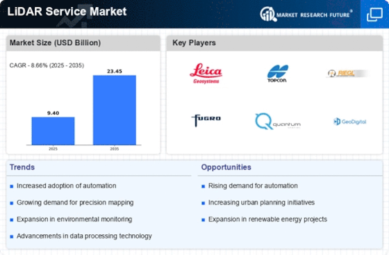
    As per MRFR analysis, the LiDAR Service Market Size was estimated at 9.405 USD Billion in 2024. The LiDAR Service industry is projected to grow from 10.22 USD Billion in 2025 to 23.45 USD Billion by 2035, exhibiting a compound annual growth rate (CAGR) of 8.66 during the forecast period 2025 - 2035.

    Key Market Trends & Highlights

    The LiDAR Service Market is experiencing robust growth driven by technological advancements and increasing applications across various sectors.

    • The market is witnessing increased adoption in infrastructure development, particularly in North America, which remains the largest market.
    • Environmental monitoring continues to dominate the LiDAR service market, reflecting a growing emphasis on sustainability and conservation efforts.
    • Asia-Pacific is emerging as the fastest-growing region, fueled by rapid urbanization and smart city initiatives.
    • Key market drivers include the rising demand for precision agriculture and advancements in autonomous vehicles, which are significantly influencing market dynamics.

    Market Size & Forecast

    2024 Market Size 9.405 (USD Billion)
    2035 Market Size 23.45 (USD Billion)
    CAGR (2025 - 2035) 8.66%

    Major Players

    Leica Geosystems (CH), Topcon Positioning Systems (US), Riegl Laser Measurement Systems (AT), Fugro (NL), Quantum Spatial (US), GeoDigital (US), Merrick & Company (US), NV5 Global (US), AeroMetric (US)

    Lidar Service Market Trends

    The LiDAR Service Market is currently experiencing a transformative phase, driven by advancements in technology and increasing demand across various sectors. The integration of LiDAR services into industries such as agriculture, forestry, and urban planning appears to enhance operational efficiency and decision-making processes. As organizations recognize the value of precise data collection and analysis, the adoption of LiDAR technology is likely to expand. Furthermore, the growing emphasis on environmental monitoring and sustainable practices suggests that LiDAR services will play a crucial role in addressing ecological challenges. In addition, the LiDAR Service Market is witnessing a surge in applications related to autonomous vehicles and smart city initiatives. The ability to generate high-resolution three-dimensional maps is becoming increasingly vital for navigation and infrastructure development. This trend indicates a shift towards more innovative uses of LiDAR technology, potentially leading to new business models and partnerships. As the market evolves, stakeholders must remain agile to adapt to emerging opportunities and challenges, ensuring that they leverage the full potential of LiDAR services in a rapidly changing landscape.

    Increased Adoption in Infrastructure Development

    The LiDAR Service Market is seeing heightened utilization in infrastructure projects, where accurate topographical data is essential. This trend is driven by the need for precise measurements in construction and maintenance, facilitating better planning and execution.

    Growth in Environmental Monitoring

    There is a notable rise in the application of LiDAR services for environmental assessments. This trend reflects a growing awareness of the importance of monitoring natural resources and ecosystems, enabling more informed conservation efforts.

    Emergence of Smart City Solutions

    The integration of LiDAR technology into smart city frameworks is becoming increasingly prevalent. This trend suggests a shift towards leveraging data for urban planning and management, enhancing the quality of life for residents.

    The increasing demand for precise topographical data across various sectors, including urban planning and environmental monitoring, underscores the pivotal role of LiDAR technology in shaping future geospatial analysis.

    U.S. Geological Survey

    Lidar Service Market Drivers

    Advancements in Autonomous Vehicles

    The LiDAR Service Market is significantly influenced by advancements in autonomous vehicle technology. As automotive manufacturers increasingly integrate LiDAR systems for navigation and obstacle detection, the demand for high-resolution mapping and real-time data processing is escalating. This integration is essential for ensuring safety and efficiency in self-driving cars. Market analysis suggests that the automotive sector is expected to account for a substantial share of the LiDAR market, with projections indicating a growth rate of approximately 20% annually. This trend underscores the critical role of LiDAR services in the development of next-generation transportation solutions.

    Expansion of Urban Planning Initiatives

    The LiDAR Service Market is benefiting from the expansion of urban planning initiatives across various regions. City planners and architects are increasingly utilizing LiDAR technology to create accurate 3D models of urban landscapes, which facilitate better decision-making in infrastructure development. The ability to capture detailed spatial data allows for improved land use planning, environmental assessments, and disaster management strategies. Recent statistics indicate that the urban planning sector is projected to invest heavily in LiDAR services, with an expected growth rate of around 12% over the next few years. This investment reflects a growing recognition of the value of precise data in shaping sustainable urban environments.

    Rising Demand for Precision Agriculture

    The LiDAR Service Market is experiencing a notable surge in demand due to the increasing need for precision agriculture. Farmers and agricultural companies are leveraging LiDAR technology to enhance crop management, optimize irrigation, and improve yield forecasting. This technology allows for detailed topographical mapping and soil analysis, which are crucial for effective land use. According to recent data, the adoption of LiDAR in agriculture is projected to grow at a compound annual growth rate of over 15% in the coming years. This trend indicates a shift towards data-driven farming practices, where LiDAR services play a pivotal role in maximizing productivity and sustainability in agricultural operations.

    Integration of LiDAR with GIS Technologies

    The LiDAR Service Market is experiencing a transformative phase with the integration of LiDAR technology and Geographic Information Systems (GIS). This synergy enhances data analysis capabilities, allowing for more comprehensive spatial analysis and visualization. The combination of LiDAR and GIS is particularly beneficial in sectors such as urban planning, forestry, and disaster management. Market trends suggest that this integration could lead to a growth rate of approximately 15% in the LiDAR services sector. As organizations seek to leverage advanced analytics for better decision-making, the demand for integrated LiDAR and GIS solutions is likely to rise significantly.

    Increased Focus on Environmental Conservation

    The LiDAR Service Market is witnessing growth driven by an increased focus on environmental conservation efforts. Organizations and governments are employing LiDAR technology for habitat mapping, forest management, and biodiversity assessments. This technology provides critical insights into vegetation structure and land cover changes, which are essential for effective conservation strategies. Data indicates that the environmental monitoring sector is likely to expand its use of LiDAR services, with a projected growth rate of 10% annually. This trend highlights the importance of accurate data in addressing environmental challenges and promoting sustainable practices.

    Market Segment Insights

    By Application: Environmental Monitoring (Largest) vs. Transportation and Logistics (Fastest-Growing)

    The LiDAR Service Market showcases significant diversity across its various application segments. Environmental Monitoring holds the largest market share, driven by increasing demand for precise and reliable data in ecological assessments and natural resource management. Following closely is Transportation and Logistics, which is rapidly expanding due to advancements in automated delivery systems and urban planning initiatives that leverage LiDAR technology for efficiency and safety. The growth trends in these segments are influenced by an increasing focus on sustainability and infrastructure development. Environmental Monitoring is leveraging regulatory pressures and heightened awareness of climate change impacts. Conversely, Transportation and Logistics is being propelled by the integration of smart technologies and the need for improved logistics solutions in urban environments, making it the fastest-growing segment in the LiDAR services market.

    Environmental Monitoring (Dominant) vs. Coastal and Marine Applications (Emerging)

    Environmental Monitoring is currently the dominant segment within the LiDAR Service Market, characterized by its extensive applications in ecological assessments, wildlife tracking, and forest management. This segment benefits from increased funding for environmental projects and a growing necessity for accurate topographical data, which assists in informed decision-making. On the other hand, Coastal and Marine Applications are emerging segments that harness LiDAR technology for shoreline mapping and underwater surveys. Although they currently hold a smaller share, their growth potential is fueled by rising concerns over sea-level rise and coastal erosion, making them increasingly relevant in environmental planning and management. Together, these segments illustrate a compelling landscape of innovation and necessity in the LiDAR services market.

    By Technology: Terrestrial LiDAR (Largest) vs. Aerial LiDAR (Fastest-Growing)

    In the LiDAR Service Market, Terrestrial LiDAR stands out as the largest segment, dominating the market share due to its extensive applications in mapping and surveying. Its precision and reliability make it the preferred choice for ground-level data capture. Conversely, Aerial LiDAR, while currently smaller in market share, is rapidly gaining traction, especially in sectors like environmental monitoring and urban planning, thanks to its ability to cover large areas more efficiently.

    Technology: Terrestrial LiDAR (Dominant) vs. Aerial LiDAR (Emerging)

    Terrestrial LiDAR is well-established in the LiDAR Service Market, primarily used for detailed ground surveys, civil engineering projects, and construction site management. Its capabilities for capturing high-resolution data at close range make it invaluable for professionals seeking accuracy in terrain modeling. On the other hand, Aerial LiDAR is emerging as a powerful tool, catering to diverse applications such as forestry management, flood mapping, and infrastructure inspections. The advancements in drone technology have further enhanced the efficiency and accessibility of Aerial LiDAR, propelling its adoption across various industries. As the demand for geospatial data increases, both segments are poised to play crucial roles in shaping the future of this market.

    By End Use: Government and Public Sector (Largest) vs. Commercial Sector (Fastest-Growing)

    In the LiDAR service market, the Government and Public Sector has established itself as the largest segment, leveraging LiDAR technology for infrastructure planning, environmental monitoring, and public safety. Conversely, the Commercial Sector is witnessing rapid expansion as businesses increasingly adopt LiDAR for applications in mapping, construction, and transportation. This growth is driven by the rising demand for accurate and efficient data collection in commercial projects, enabling organizations to enhance operational efficiency and decision-making. The growth trends in the LiDAR service market highlight a significant shift towards increasing integration of advanced technologies in the Government and Public Sector. Emerging applications such as disaster management, urban planning, and autonomous vehicles are bolstering demand. In contrast, the Commercial Sector's adoption of LiDAR services is fueled by the need for precision in development projects and the growing trend of digitization across industries, positioning it as a key driver for market growth.

    Government and Public Sector (Dominant) vs. Utility Companies (Emerging)

    The Government and Public Sector stands as the dominant force in the LiDAR service market, harnessing advanced data collection and spatial analysis for various governmental applications such as public safety, land management, and infrastructure development. This segment benefits from substantial public funding and investments, ensuring ongoing demand for innovative LiDAR solutions. On the other hand, Utility Companies represent an emerging segment that is gradually integrating LiDAR technology into their operations for tasks like power line inspection, vegetation management, and asset monitoring. As these companies recognize the efficiency and cost-saving benefits of LiDAR for maintaining infrastructure, this segment is anticipated to witness significant growth, enhancing its market position and relevance in the LiDAR service landscape.

    By Deliverable Type: Point Cloud Data (Largest) vs. 3D Models (Fastest-Growing)

    In the LiDAR service market, the deliverable types are segmented among Point Cloud Data, 3D Models, Geospatial Analysis, and Digital Elevation Models. Point Cloud Data currently holds the largest share due to its widespread applications in various industries, such as engineering, construction, and surveying. Meanwhile, 3D Models are experiencing rapid adoption, driven by advancements in technology and increased demand in sectors like gaming and virtual reality, making it the fastest-growing segment.

    Geospatial Analysis (Dominant) vs. Digital Elevation Models (Emerging)

    Geospatial Analysis stands out as a dominant deliverable in the LiDAR market, providing critical insights through comprehensive spatial data interpretation essential for urban planning, environmental monitoring, and resource management. This segment benefits from the integration of AI and machine learning, enhancing analysis precision. Conversely, Digital Elevation Models are viewed as an emerging segment, gaining traction particularly for applications in flood modeling, terrain analysis, and infrastructure development. The increasing emphasis on environmental sustainability and disaster management is driving their growth, positioning them as a valuable tool in sectors requiring detailed elevation data.

    Get more detailed insights about Lidar Service Market

    Regional Insights

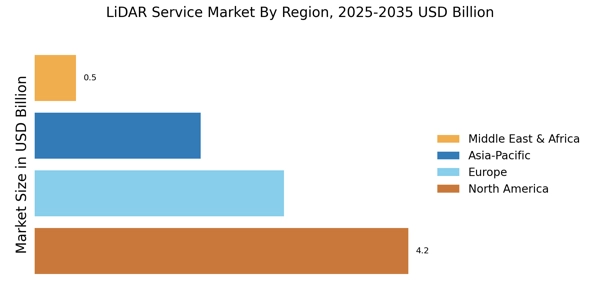
    The LiDAR Service Market exhibits significant growth across various regions, with an overall valuation of 7.96 USD Billion in 2023 and expected growth in the upcoming years. North America leads with a major contribution, valued at 3.2 USD Billion in 2023, reflecting its dominance due to advanced technology adoption and a robust infrastructure sector. Europe follows closely, valued at 1.8 USD Billion, potentially driven by rising governmental projects and environmental monitoring. The APAC region showcases promising growth, with a valuation of 2.4 USD Billion, largely fueled by increasing investments in urban planning and development.

    South America and MEA present smaller market shares, valued at 0.3 USD Billion and 0.26 USD Billion, respectively, indicating emerging opportunities in infrastructure and surveying but facing challenges in technology adoption and investment. Overall, these regional dynamics illustrate varied market growth trajectories, with North America dominating, while Europe and APAC are noted for their growth potential, supported by the LiDAR Service Market Statistics that highlight opportunities for expansion and the modernization of services in different sectors.

    LiDAR Service Market Regional Insights

    Source: Primary Research, Secondary Research, Market Research Future Database and Analyst Review

    Key Players and Competitive Insights

    The LiDAR Service Market is characterized by a dynamic and competitive landscape where various companies are striving to capture a significant share of the market. The adoption of LiDAR technology across diverse sectors such as agriculture, forestry, mining, transportation, and urban planning has accelerated the demand for LiDAR services globally. As more organizations recognize the benefits of high-resolution, three-dimensional data for analysis and decision-making, providers are enhancing their service offerings and expanding their technological capabilities.

    The market's growth is supported by advancements in LiDAR technology, increasing investments in research and development, and a growing emphasis on automation and efficiency in mapping and surveying applications. Consequently, competition among established players and emerging startups is intensifying, leading to innovations and collaborations in the LiDAR service sector.

    Geosensors has established a strong presence within the LiDAR Service Market, leveraging its cutting-edge technology and a robust portfolio of service offerings. The company is known for its expertise in designing and deploying LiDAR systems that provide accurate and reliable data for various applications. With a focus on quality and customer satisfaction, Geosensors has built a reputation for delivering high-resolution mapping and surveying solutions that meet the specific needs of its clients.

    The company’s strength lies in its ability to integrate advanced sensor technology with comprehensive data processing capabilities, allowing it to offer value-added services that enhance the insights derived from LiDAR data. Through continuous innovation and a deep understanding of customer requirements, Geosensors is well-positioned to compete effectively in the evolving LiDAR service market.

    Trimble has emerged as a key player in the LiDAR Service Market, known for its commitment to providing innovative geospatial solutions. The company utilizes its vast experience and technological prowess to offer a wide range of LiDAR services that cater to various industries, including construction, agriculture, and environmental management. Trimble's strength lies in its integrated approach to data collection and processing, which combines LiDAR technology with other geospatial tools to provide comprehensive insights. With a focus on enhancing productivity and efficiency, Trimble continues to develop advanced solutions that facilitate better decision-making for its clients.

    The company's ongoing investment in research and development further solidifies its position as a leader in the market, enabling it to stay ahead of industry trends and maintain a competitive edge in the rapidly evolving landscape of LiDAR services.

    Key Companies in the Lidar Service Market market include

    Industry Developments

    Recent developments in the LiDAR Service Market indicate a growing demand for advanced surveying and mapping technologies, driven by the need for accurate data in various industries such as agriculture, forestry, and urban planning. Companies like Geosensors, Trimble, and 3D Laser Mapping are actively enhancing their service offerings to accommodate this increased demand. Notably, Airbus Defence and Space, along with Fugro, are expanding their partnerships to integrate LiDAR services with satellite data for improved geo-spatial analysis. Quantum Spatial has also announced a collaboration with LandAir Surveys to provide robust solutions in infrastructure development.

    In terms of mergers and acquisitions, Teledyne Technologies’ acquisition of FLIR Systems has strengthened its market position, allowing it to offer a more comprehensive suite of imaging and sensing technologies alongside companies like Leica Geosystems and RIEGL Laser Measurement Systems, which are continuously innovating their product lines. Meanwhile, Velodyne LiDAR is experiencing growth due to its pioneering LiDAR technology, which is increasingly pivotal in sectors such as autonomous vehicles and smart city frameworks. Overall, these dynamics are significantly shaping the landscape of the LiDAR Service Market.

    .webp

    Future Outlook

    Lidar Service Market Future Outlook

    The LiDAR Service Market is projected to grow at an 8.66% CAGR from 2024 to 2035, driven by advancements in technology, increasing demand for precision mapping, and applications in various sectors.

    New opportunities lie in:

    • Development of integrated LiDAR and GIS platforms for enhanced data analysis.
    • Expansion into emerging markets with tailored LiDAR solutions for local industries.
    • Partnerships with drone manufacturers to offer comprehensive aerial surveying services.

    By 2035, the LiDAR Service Market is expected to be robust, driven by innovation and diverse applications.

    Market Segmentation

    Lidar Service Market End Use Outlook

    • Government and Public Sector
    • Commercial Sector
    • Research and Development
    • Utility Companies

    Lidar Service Market Technology Outlook

    • Terrestrial LiDAR
    • Aerial LiDAR
    • Mobile LiDAR
    • Short-range LiDAR
    • Long-range LiDAR

    Lidar Service Market Application Outlook

    • Environmental Monitoring
    • Construction and Mining
    • Transportation and Logistics
    • Coastal and Marine Applications
    • Archaeology

    Lidar Service Market Deliverable Type Outlook

    • Point Cloud Data
    • 3D Models
    • Geospatial Analysis
    • Digital Elevation Models

    Report Scope

    MARKET SIZE 20249.405(USD Billion)
    MARKET SIZE 202510.22(USD Billion)
    MARKET SIZE 203523.45(USD Billion)
    COMPOUND ANNUAL GROWTH RATE (CAGR)8.66% (2024 - 2035)
    REPORT COVERAGERevenue Forecast, Competitive Landscape, Growth Factors, and Trends
    BASE YEAR2024
    Market Forecast Period2025 - 2035
    Historical Data2019 - 2024
    Market Forecast UnitsUSD Billion
    Key Companies ProfiledMarket analysis in progress
    Segments CoveredMarket segmentation analysis in progress
    Key Market OpportunitiesIntegration of artificial intelligence enhances data analysis capabilities in the LiDAR Service Market.
    Key Market DynamicsTechnological advancements and regulatory changes drive growth and competition in the LiDAR service market.
    Countries CoveredNorth America, Europe, APAC, South America, MEA

    Leave a Comment

    FAQs

    What is the projected market size of the LiDAR Service Market by 2034?

    The LiDAR Service Market is expected to be valued at 21.58 USD Billion by the year 2034.

    What is the expected compound annual growth rate (CAGR) for the LiDAR Service Market from 2025 to 2034?

    The expected CAGR for the LiDAR Service Market from 2025 to 2034 is 8.66%.

    Which application segment is projected to have the highest market value by 2032?

    The Construction and Mining application segment is projected to reach a market value of 5.55 USD Billion by 2032.

    What will be the market value of the Environmental Monitoring segment in 2032?

    The Environmental Monitoring segment is expected to have a market value of 4.12 USD Billion by 2032.

    Which region is anticipated to dominate the LiDAR Service Market by 2032?

    North America is anticipated to dominate the LiDAR Service Market with a projected value of 6.8 USD Billion by 2032.

    What is the projected market size for the APAC region in the LiDAR Service Market by 2032?

    The APAC region is projected to reach a market size of 5.2 USD Billion by 2032.

    Who are the key players in the LiDAR Service Market?

    Key players in the LiDAR Service Market include Geosensors, Trimble, and RIEGL Laser Measurement Systems, among others.

    What will be the market value for Transportation and Logistics in 2032?

    The market value for Transportation and Logistics is projected to be 3.9 USD Billion by 2032.

    What is the expected market size for Coastal and Marine Applications by 2032?

    Coastal and Marine Applications are expected to reach a market size of 1.98 USD Billion by 2032.

    What will be the estimated market value for the South American region in 2032?

    The estimated market value for the South America region in 2032 is projected to be 0.7 USD Billion.

    Download Free Sample

    Kindly complete the form below to receive a free sample of this Report

    Case Study
    Chemicals and Materials

    Compare Licence

    ×
    Features License Type
    Single User Multiuser License Enterprise User
    Price $4,950 $5,950 $7,250
    Maximum User Access Limit 1 User Upto 10 Users Unrestricted Access Throughout the Organization
    Free Customization
    Direct Access to Analyst
    Deliverable Format
    Platform Access
    Discount on Next Purchase 10% 15% 15%
    Printable Versions