info@marketresearchfuture.com   📞 +1 (855) 661-4441(US)   📞 +44 1720 412 167(UK)   📞 +91 2269738890(APAC)
Certified Global Research Member
Isomar 1 Iso 1
Key Questions Answered
  • Global Market Outlook
  • In-depth analysis of global and regional trends
  • Analyze and identify the major players in the market, their market share, key developments, etc.
  • To understand the capability of the major players based on products offered, financials, and strategies.
  • Identify disrupting products, companies, and trends.
  • To identify opportunities in the market.
  • Analyze the key challenges in the market.
  • Analyze the regional penetration of players, products, and services in the market.
  • Comparison of major players financial performance.
  • Evaluate strategies adopted by major players.
  • Recommendations
Why Choose Market Research Future?
  • Vigorous research methodologies for specific market.
  • Knowledge partners across the globe
  • Large network of partner consultants.
  • Ever-increasing/ Escalating data base with quarterly monitoring of various markets
  • Trusted by fortune 500 companies/startups/ universities/organizations
  • Large database of 5000+ markets reports.
  • Effective and prompt pre- and post-sales support.

Italy Photogrammetry Software Market Research Report By Photogrammetry Type (Aerial Photogrammetry, Terrestrial Photogrammetry, Close-Range Photogrammetry, Satellite Photogrammetry, Underwater Photogrammetry, Others), By Deployment Mode (On-premises, Cloud-based), By Pricing Model (Commercial/Proprietary Software, Open-Source Software), and By End Use Vertical (Architecture, Engineering, Construction (AEC), Surveying and Mapping, Mining and Natural Resources, Oil and Gas, Agriculture and Forestry, Cultural Heritage and Archaeology, Defense


ID: MRFR/ICT/60066-HCR | 200 Pages | Author: Aarti Dhapte| August 2025

Italy Photogrammetry Software Market Overview

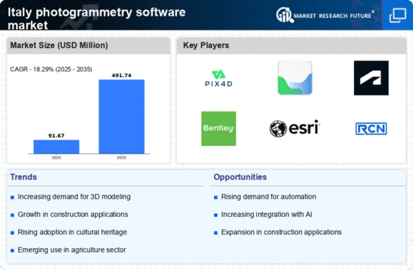
As per MRFR analysis, the Italy Photogrammetry Software Market Size was estimated at 45.9 (USD Million) in 2023.The Italy Photogrammetry Software Market is expected to grow from 54.25(USD Million) in 2024 to 123 (USD Million) by 2035. The Italy Photogrammetry Software Market CAGR (growth rate) is expected to be around 7.726% during the forecast period (2025 - 2035).

Key Italy Photogrammetry Software Market Trends Highlighted

Technology breakthroughs and the growing need for precise data gathering and analysis across a range of industries are driving the photogrammetry software market in Italy. The adoption of photogrammetry software is being driven by the rise in the usage of drones for surveying in sectors including environmental monitoring, agriculture, and construction.

In particular, Italian urban planning and infrastructure projects are increasing the demand for accurate mapping solutions. The government's dedication to digital transformation in areas such as environmental protection and urban planning is creating an atmosphere that is favorable to this market's expansion.Italy offers a number of chances for the photogrammetry software industry to flourish. For example, there is a growing demand for high-quality geographical data as local governments place more emphasis on smart city programs.

Software developers now have the chance to customize their products to address certain urban planning requirements, like resource distribution, traffic control, and zoning, thanks to this development. Collaboration between tech companies and educational institutions can also result in software advancements that increase the product's regional applicability.

Recently, photogrammetry software has increasingly integrated machine learning and artificial intelligence, enabling better image processing and analysis. These technologies are being used more and more by Italian companies to increase efficiency and production.

Additionally, organizations are using photogrammetry for conservation, resource management, and environmental monitoring as a result of the emphasis on sustainability in many areas. This further encourages interest in and investments in photogrammetry solutions throughout the country, which is in line with Italy's larger objectives for sustainable development.

Italy Photogrammetry Software Market size

Source: Primary Research, Secondary Research, MRFR Database and Analyst Review

Increasing Demand for 3D Mapping Applications

The Italy Photogrammetry Software Market is witnessing a significant surge in demand for 3D mapping applications across various sectors such as construction, architecture, and cultural heritage preservation. The Italian government has launched several initiatives aimed at improving urban planning and infrastructure development, which has in turn increased the need for advanced mapping technologies.

According to the Italian Ministry of Culture, over 600 historical sites are undergoing restoration projects where photogrammetry plays a critical role in creating precise 3D models. This illustrates that the demand for photogrammetry software is closely aligned with national efforts towards cultural preservation and urban development, signaling strong growth potential for this industry in Italy.

Government Investment in Technological Advancements

The Italian government has committed substantial funding towards the digitalization of public services, which includes investments in innovative technologies such as photogrammetry. The ongoing 'Digital Italy' initiative underscores the government's goal, aiming to foster digital innovation through a budget of approximately 6 billion euros allocated for technological advancements by 2025.

As a result, the Italy Photogrammetry Software Market is expected to benefit from increased public sector adoption and funding, enhancing the software's visibility and application across various domains like surveying, transportation, and disaster management.

Rising Popularity of Drone Technology

The proliferation of drone technology is significantly contributing to the growth of the Italy Photogrammetry Software Market. Drones equipped with high-resolution cameras are increasingly being utilized for surveying and mapping tasks.

The Italian Civil Aviation Authority has reported a 50% increase in the number of registered commercial drones since 2020, signaling the widespread acceptance of this technology.

Photogrammetry software is essential for processing the data gathered by these drones, leading to a symbiotic relationship that propels market growth. This trend is further supported by various Italian startups focusing on innovative drone applications for agriculture, real estate, and emergency response services.

Italy Photogrammetry Software Market Segment Insights

Photogrammetry Software Market Photogrammetry Type Insights

The Italy Photogrammetry Software Market reflects a robust landscape influenced by various demands across multiple applications, prominently within the realm of Photogrammetry Type. Aerial Photogrammetry, which harnesses drone and aircraft capture methods, is gaining significant traction in Italy due to its advantages in land surveying, urban planning, and environmental assessments.

This method allows for high-resolution imagery and mapping that is crucial for infrastructure projects and conservation efforts in a country rich in historical and natural resources. Terrestrial Photogrammetry, often employed in the documentation of cultural heritage and construction, plays a vital role in Italy, where preserving historical sites is of utmost importance.

This type utilizes ground-based techniques to capture detailed measurements and spatial data, facilitating accurate modeling and analysis for architects and engineers. Close-Range Photogrammetry operates effectively in applications where detail at a closer proximity is necessary, such as in museums and for academic research.

This technique is critical for capturing intricate details, especially relevant in an art-rich nation like Italy, fostering a better understanding of artifacts and their context. Meanwhile, Satellite Photogrammetry leverages data from satellites to provide extensive coverage, which is particularly valuable for monitoring environmental changes and urban growth across Italian regions.

The capabilities of satellite imagery to monitor agricultural practices further aligns with Italy's strong agricultural economy, making it a cornerstone in resource management. Underwater Photogrammetry represents an innovative front, especially relevant around Italy's diverse coastal regions.

The ability to explore and map underwater archaeological sites serves essential functions in marine conservation and heritage preservation, helping to maintain Italy's rich maritime history. The Others’ category encompasses other specialized methods and technologies that support niche applications in the market.

This diversity within the Photogrammetry Type segment showcases Italy's commitment to leveraging cutting-edge technology across various fields, thus fortifying its position in the Italy Photogrammetry Software Market, fostering growth, innovation, and a sustainable approach to resource management and cultural heritage preservation.As such, the market is poised for advancement, with each method contributing uniquely to the overall fabric of Photogrammetry in Italy.

Italy Photogrammetry Software Market Segment

Source: Primary Research, Secondary Research, MRFR Database and Analyst Review

Photogrammetry Software Market Deployment Mode Insights

The Deployment Mode segment of the Italy Photogrammetry Software Market encompasses both On-premises and Cloud-based solutions, each with distinct characteristics and advantages. On-premises software offers organizations enhanced control over their data and systems, making it a preferred choice for industries requiring strict data compliance and security measures.This mode allows companies to customize their software according to specific operational needs, which is particularly valuable in sectors like construction and surveying that rely heavily on accurate data for project execution.

In contrast, Cloud-based solutions are gaining traction due to their flexibility and scalability, enabling users to access software from various devices and locations. This deployment mode supports real-time collaboration, essential for projects that involve multiple stakeholders.

As businesses in Italy continue to digitize their operations, the demand for both deployment methods is expected to grow, driven by the need for efficiency and precise data collection. Overall, the Deployment Mode segment reflects a significant part of the Italy Photogrammetry Software Market, showcasing how technological advancements are reshaping the landscape for various industries.With the Italian government promoting digital innovation, both On-premises and Cloud-based solutions are set to play crucial roles in the evolution of photogrammetry applications across sectors.

Photogrammetry Software Market Pricing Model Insights

The Italy Photogrammetry Software Market is experiencing significant evolution, particularly in the Pricing Model segment, where distinct categories like Commercial/Proprietary Software and Open-Source Software are making their mark.

Commercial/Proprietary Software has emerged as a significant player in the market, catering to businesses seeking robust features, extensive customer support, and regular updates. This segment often dominates due to the added value it provides through additional services and advanced functionalities tailored to professional needs.

In contrast, Open-Source Software offers an attractive alternative, gaining traction among academic institutions, small enterprises, and hobbyists. Its accessibility fosters innovation and customization, allowing users in Italy to adapt the software to specific needs without the constraints of licensing fees.

The growing demand for efficiency in various industries, coupled with Italy's rich heritage in surveying and architecture, has fueled interest in adopting both Commercial and Open-Source solutions, creating a diverse landscape for photogrammetry software adoption.This differentiation in Pricing Model not only reflects varying user needs but also exemplifies the balance between proprietary innovation and collaborative development in the Photogrammetry Software Market.

Photogrammetry Software Market End Use Vertical Insights

The Italy Photogrammetry Software Market is increasingly being shaped by diverse applications across various sectors under the End Use Vertical. The Architecture, Engineering, and Construction (AEC) segment plays a crucial role in modernizing building practices and enhancing project efficiency through accurate visual data.

Surveying and Mapping are essential for infrastructure development, urban planning, and environmental management, facilitating essential data collection and analysis. The Mining and Natural Resources segment utilizes photogrammetry for efficient resource exploration and impact assessments, while the Oil and Gas sector leverages this technology in exploration and site monitoring efforts.

In Agriculture and Forestry, photogrammetry aids in precision farming, allowing for targeted resource management. Cultural Heritage and Archaeology utilize these tools for documentation and preservation, providing insights into historical sites.

The Defense and Security segment benefits from advanced topographical mapping for strategic planning. Manufacturing and Industrial applications utilize photogrammetry for quality control and product development. The Film, Animation, and Gaming industries are adopting these technologies for creating more immersive experiences and realistic environments.

Research and Education departments are also exploring photogrammetry for educational purposes, enhancing learning through practical applications in various scientific fields. Overall, the versatility of the photogrammetry software in these areas demonstrates its significance in driving progress and innovation in Italy's economy.

Italy Photogrammetry Software Market Key Players and Competitive Insights

The Italy Photogrammetry Software Market is characterized by an evolving competitive landscape marked by the presence of several key players leveraging technological advancements and innovative solutions to cater to the specific needs of customers in various sectors such as construction, architecture, and environmental management.

This competitive environment is largely driven by the increasing demand for efficient and accurate data capturing methods that photogrammetry software offers. Companies are continuously looking for ways to enhance their product offerings while addressing local market requirements, leading to a dynamic interplay between established providers and emerging players.

The collaborations, partnerships, and expansion strategies among these companies further add complexity to the market, influencing pricing strategies, product development, and service delivery mechanisms.Agisoft demonstrates a solid footprint in the Italian market, especially with its flagship solution that enables professionals to generate 3D spatial data efficiently. The company has gained recognition for its user-friendly interface and high-quality outputs, aiding users across various industries in improving project outcomes.

Agisoft's strength lies in its ability to provide detailed performance analytics, seamless integration with other tools, and an extensive support network for local users. This commitment to quality and customer support enhances Agisoft's reputation among users in Italy, ensuring its sustained prominence in the competitive arena of photogrammetry software.Autodesk holds a significant position in the Italy Photogrammetry Software Market, owing to its extensive portfolio of software solutions tailored for the construction, architecture, and engineering sectors.

Known for its advanced capabilities in 3D modeling and design, Autodesk has integrated photogrammetry functionalities into its suite of products, providing users with enhanced tools for surveying, modeling, and project visualization.The company's strength is bolstered by its continuous investment in research and development, enabling it to stay ahead of technological trends and improve the functionality of its offerings. Autodesk has also pursued strategic mergers and acquisitions, further strengthening its market presence and capability to deliver a comprehensive suite of services.

By fostering local partnerships and networks, Autodesk is well-positioned to address the unique challenges faced by Italian professionals in the realm of photogrammetry, ensuring its ongoing relevance and competitive edge in the market.

Key Companies in the Italy Photogrammetry Software Market Include:

  • Agisoft
  • Autodesk
  • Esri
  • Capturing Reality
  • RealityCapture
  • DroneDeploy
  • GeoSLAM
  • Trimble
  • Bentley Systems
  • Topcon
  • Pix4D

Italy Photogrammetry Software Market Developments

Italian construction and agritech teams may now effectively create 3D models using smartphones and drones thanks to Pix4D's October 2023 release of Pix4Dcatch 2.0, a significant update to its mobile photogrammetry tool that improves field accuracy and user experience.

RealityCapture's pricing change under Epic Games in April 2024—free use for organizations making less than $1 million USD—accelerated acceptance among Italian SMEs, cultural heritage experts, and academic users looking for high-fidelity 3D model outputs.

In February 2025, user forums in Italy regularly rated RealityCapture higher than its competitors due to its speed and mesh quality. In the meantime, Agisoft Metashape, Autodesk ReCap Pro, and Esri ArcGIS photogrammetry modules were progressively used by Italian architecture and survey firms for UAV-based mapping and modeling activities throughout 2023–2025.

Italian infrastructure operations were still supported by Trimble and Topcon systems, particularly for mapping buildings and terrain. Italian digital twin and airport projects utilizing sophisticated imaging operations embraced Bentley's ContextCapture. LiDAR–image fusion was made possible in Italian scanning operations by GeoSLAM devices.

Additionally, DroneDeploy is still the preferred platform for rapid aerial mapping in land-use studies and construction, and it is regularly mentioned in Italian trade journals.

All of these trends show that, as of mid-2025, the most well-known and widely used photogrammetry software suppliers in Italy are Pix4D, RealityCapture, Agisoft, Autodesk, Esri, Trimble, Topcon, Bentley Systems (ContextCapture), GeoSLAM, and DroneDeploy.

Italy Photogrammetry Software Market Segmentation Insights

Photogrammetry Software Market Photogrammetry Type Outlook

  • Aerial Photogrammetry
  • Terrestrial Photogrammetry
  • Close-Range Photogrammetry
  • Satellite Photogrammetry
  • Underwater Photogrammetry
  • Others

Photogrammetry Software Market Deployment Mode Outlook

  • On-premises
  • Cloud-based

Photogrammetry Software Market Pricing Model Outlook

  • Commercial/Proprietary Software
  • Open-Source Software

Photogrammetry Software Market End Use Vertical Outlook

  • Architecture
  • Engineering
  • Construction (AEC)
  • Surveying and Mapping
  • Mining and Natural Resources
  • Oil and Gas
  • Agriculture and Forestry
  • Cultural Heritage and Archaeology
  • Defense and Security
  • Manufacturing and Industrial
  • Film
  • Animation
  • Gaming
  • Research And Education
 
Report Attribute/Metric Source: Details
MARKET SIZE 2023 45.9(USD Million)
MARKET SIZE 2024 54.25(USD Million)
MARKET SIZE 2035 123.0(USD Million)
COMPOUND ANNUAL GROWTH RATE (CAGR) 7.726% (2025 - 2035)
REPORT COVERAGE Revenue Forecast, Competitive Landscape, Growth Factors, and Trends
BASE YEAR 2024
MARKET FORECAST PERIOD 2025 - 2035
HISTORICAL DATA 2019 - 2024
MARKET FORECAST UNITS USD Million
KEY COMPANIES PROFILED Agisoft, Autodesk, Esri, 3D Reshaper, SWT Group, Capturing Reality, RealityCapture, DroneDeploy, GeoSLAM, Skydio, Trimble, Zenuity, Bentley Systems, Topcon, Pix4D
SEGMENTS COVERED Photogrammetry Type, Deployment Mode, Pricing Model, End Use Vertical
KEY MARKET OPPORTUNITIES Increased demand for surveying services, Growing interest in 3D modeling, Expansion in construction and real estate, Adoption in environmental monitoring, Integration with UAV technologies
KEY MARKET DYNAMICS growing demand for 3D modeling, increasing use in construction, advancements in drone technology, rise in surveying applications, government investments in infrastructure
COUNTRIES COVERED Italy


Frequently Asked Questions (FAQ) :

The Italy Photogrammetry Software Market is expected to be valued at 54.25 million USD in 2024.

In 2035, the overall market value is projected to reach 123.0 million USD.

The expected CAGR for the Italy Photogrammetry Software Market from 2025 to 2035 is 7.726 percent.

Aerial Photogrammetry is expected to dominate the market with a value of 16.5 million USD in 2024.

The market value for Satellite Photogrammetry is projected to be 24.0 million USD in 2035.

Key players in the market include Agisoft, Autodesk, Esri, and Pix4D.

Underwater Photogrammetry is expected to be valued at 4.75 million USD in 2024.

Terrestrial Photogrammetry is anticipated to grow to a market value of 32.0 million USD by 2035.

Close-Range Photogrammetry is projected to rise from 8.5 million USD in 2024 to 19.5 million USD in 2035.

The growth in applications such as mapping, surveying, and design are driving the market forward.

Comments

Leading companies partner with us for data-driven Insights.

clients

Kindly complete the form below to receive a free sample of this Report

We do not share your information with anyone. However, we may send you emails based on your report interest from time to time. You may contact us at any time to opt-out.

Tailored for You
  • Dedicated Research on any specifics segment or region.
  • Focused Research on specific players in the market.
  • Custom Report based only on your requirements.
  • Flexibility to add or subtract any chapter in the study.
  • Historic data from 2014 and forecasts outlook till 2040.
  • Flexibility of providing data/insights in formats (PDF, PPT, Excel).
  • Provide cross segmentation in applicable scenario/markets.
report-img