info@marketresearchfuture.com   📞 +1 (855) 661-4441(US)   📞 +44 1720 412 167(UK)   📞 +91 2269738890(APAC)
Certified Global Research Member
Isomar 1 Iso 1
Key Questions Answered
  • Global Market Outlook
  • In-depth analysis of global and regional trends
  • Analyze and identify the major players in the market, their market share, key developments, etc.
  • To understand the capability of the major players based on products offered, financials, and strategies.
  • Identify disrupting products, companies, and trends.
  • To identify opportunities in the market.
  • Analyze the key challenges in the market.
  • Analyze the regional penetration of players, products, and services in the market.
  • Comparison of major players financial performance.
  • Evaluate strategies adopted by major players.
  • Recommendations
Why Choose Market Research Future?
  • Vigorous research methodologies for specific market.
  • Knowledge partners across the globe
  • Large network of partner consultants.
  • Ever-increasing/ Escalating data base with quarterly monitoring of various markets
  • Trusted by fortune 500 companies/startups/ universities/organizations
  • Large database of 5000+ markets reports.
  • Effective and prompt pre- and post-sales support.

India Photogrammetry Software Market Research Report By Photogrammetry Type (Aerial Photogrammetry, Terrestrial Photogrammetry, Close-Range Photogrammetry, Satellite Photogrammetry, Underwater Photogrammetry, Others), By Deployment Mode (On-premises, Cloud-based), By Pricing Model (Commercial/Proprietary Software, Open-Source Software), and By End Use Vertical (Architecture, Engineering, Construction (AEC), Surveying and Mapping, Mining and Natural Resources, Oil and Gas, Agriculture and Forestry, Cultural Heritage and Archaeology, Defense


ID: MRFR/ICT/60068-HCR | 200 Pages | Author: Aarti Dhapte| August 2025

India Photogrammetry Software Market Overview

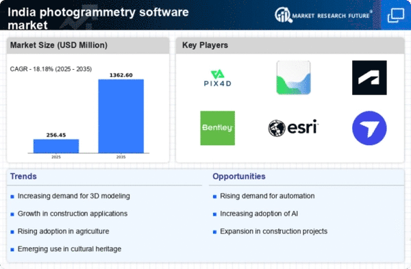
As per MRFR analysis, the India Photogrammetry Software Market Size was estimated at 196.7 (USD Million) in 2023.The India Photogrammetry Software Market is expected to grow from 350(USD Million) in 2024 to 2,200 (USD Million) by 2035. The India Photogrammetry Software Market CAGR (growth rate) is expected to be around 18.189% during the forecast period (2025 - 2035).

Key India Photogrammetry Software Market Trends Highlighted

The growing need for high-resolution mapping and modeling in a variety of industries, including urban planning, agriculture, and construction, is propelling the photogrammetry software market in India.This demand has been further stimulated by the Indian government's initiatives supporting digital transformation and infrastructure development, since geospatial technologies are being used more and more for improved project planning and execution.

Notably, government initiatives like the Digital India program seek to improve national and local capacities for using geospatial data, which serves as a key driver of the industry. Businesses that specialize in collaborative software solutions that combine photogrammetry with other geospatial technologies have a significant opportunity.

As industries like mining, real estate, and environmental monitoring grow, businesses can use photogrammetry software to increase the efficiency and accuracy of their data. A wider audience can now use mobile-based photogrammetry applications thanks to India's growing smartphone usage, which also promotes software development innovation.

Recent developments in drone technology have completely changed India's photogrammetry scene. The demands of the business are increasingly being answered by drones fitted with photogrammetry software, which allows for rapid and precise data collecting across wide areas.Additionally, photogrammetry software is increasingly integrating automation and artificial intelligence to improve user experiences and increase functionality.

Furthermore, a new generation of highly qualified experts is being prepared by the growth of educational programs and workshops centered on geospatial technologies in India, which is establishing the nation as a center for photogrammetry solutions in the larger Asia-Pacific area.

India Photogrammetry Software Market size

Source: Primary Research, Secondary Research, MRFR Database and Analyst Review

Increasing Demand for Aerial Surveying and Mapping

The demand for aerial surveying and mapping in India is significantly rising due to the implementation of various government initiatives in urban planning and rural development. According to the Ministry of Housing and Urban Affairs, the Smart Cities Mission aims to develop 100 smart cities across India.

This strong push for urbanization and efficient land use directly correlates with the need for photogrammetry software, enabling detailed mapping and data collection for urban planners and developers. Aerial mapping holds the promise of providing high-resolution data which is essential for effective city management.

Established organizations like the Survey of India are utilizing photogrammetry solutions for land use assessment and infrastructure development, thus propelling the growth of the India Photogrammetry Software Market. The professional integration of aerial imagery and photogrammetric techniques is expected to streamline the planning process, making it critical for urbanization strategies.

Growth in Construction and Infrastructure Development

India's construction sector is poised for exponential growth, driven by the ongoing need for infrastructures, such as roads, highways, and bridges. As indicated by the National Infrastructure Pipeline, an investment of approximately USD 1.4 trillion is slated for infrastructure development in India by 2024.

Photogrammetry software plays a vital role in surveying and monitoring construction projects, providing precise measurements and high-quality imaging, which are crucial for effective project management.

Major construction firms like Larsen and Toubro are increasingly adopting these advanced technologies for their projects, effectively enhancing operational efficiency, and thereby boosting the market for photogrammetry software in India. The urgency of completing infrastructure projects on time further reinforces the demand for innovative solutions within the India Photogrammetry Software Market.

Advancements in Technology and Cloud-Based Solutions

The evolution of technology, particularly the introduction of cloud computing, is reshaping the India Photogrammetry Software Market. Cloud-based photogrammetry solutions allow vast data storage, sharing, and seamless access for teams across different locations.

As businesses increasingly transition to digital platforms, the integration of more advanced algorithms and Artificial Intelligence (AI) in photogrammetry has become imperative. According to reports from the Ministry of Electronics and Information Technology, India's digital transformation is on track to reach USD 1 trillion by 2025.

Organizations such as Esri India are leveraging cloud-based technologies to provide GIS services, subsequently enhancing the usage of photogrammetry software. This shift towards technology-driven solutions is likely to significantly spur growth in the market as companies require sophisticated tools for data analysis and integration.

India Photogrammetry Software Market Segment Insights

Photogrammetry Software Market Photogrammetry Type Insights

The India Photogrammetry Software Market is characterized by diverse Photogrammetry Type segments, which include Aerial Photogrammetry, Terrestrial Photogrammetry, Close-Range Photogrammetry, Satellite Photogrammetry, Underwater Photogrammetry, and Others.

Aerial Photogrammetry is widely recognized for its ability to capture large areas quickly and efficiently, making it instrumental in topographic mapping and urban planning, leveraging advancements in drone technology. Terrestrial Photogrammetry focuses on capturing images from ground level, making it crucial for detailed surveys in construction, architecture, and heritage documentations.

Close-Range Photogrammetry plays a significant role in applications such as industrial inspections and archaeological studies due to its precision in capturing small objects or details. Satellite Photogrammetry provides broad land cover mapping and environmental monitoring, supporting governmental agencies in various ecological assessments and land use planning.

Underwater Photogrammetry has gained importance in marine research and underwater archaeology, offering crucial data for oceanographic studies. The 'Others' category encompasses various niche applications, showcasing the versatility and adoption of photogrammetry across industries in India.As the technology evolves and integrates with Artificial Intelligence and Machine Learning, the significance of these segments continues to grow, pushing for innovations and methodologies that enhance data accuracy and processing capabilities.

With a well-established base in data generation and analysis, the India Photogrammetry Software Market is poised for substantial opportunities in sectors such as construction, agriculture, mining, and environmental monitoring, fueling the ongoing growth of this industry.This diversification in photogrammetry types reflects the increasing demand for precise and efficient geospatial data, showcasing the relevance of each segment in various applications across the Indian landscape.

India Photogrammetry Software Market Segment

Source: Primary Research, Secondary Research, MRFR Database and Analyst Review

Photogrammetry Software Market Deployment Mode Insights

The Deployment Mode segment of the India Photogrammetry Software Market encompasses critical methods that enhance the accessibility and flexibility of photogrammetry solutions. On-premises deployment allows organizations to maintain control over their data and systems, making it a preferred choice for sectors that require high security and privacy, such as defense and public safety.

In contrast, cloud-based deployment offers scalability and cost-effectiveness, enabling businesses to access powerful photogrammetry tools without the need for extensive hardware investments. The increasing adoption of cloud technologies in India, bolstered by governmental initiatives promoting digital transformation, significantly drives the growth of cloud-based solutions.Moreover, the burgeoning demand for real-time data processing in industries like construction, agriculture, and urban planning further underscores the importance of both deployment modes.

As organizations continue to explore innovative ways to adopt photogrammetry technologies, the Deployment Mode segment stands out as a vital component of the India Photogrammetry Software Market, catering to diverse user needs and fostering significant advancements across various applications.Ultimately, these deployment strategies play a crucial role in shaping the future landscape of photogrammetry in India, as they adapt to evolving market requirements and technological advancements.

Photogrammetry Software Market Pricing Model Insights

The India Photogrammetry Software Market is evolving rapidly, with the Pricing Model segment reflecting diverse choices for users. The market features two prominent categories: Commercial/Proprietary Software and Open-Source Software.

Commercial software often provides advanced features and robust technical support, attracting enterprises and professionals who require dependable solutions for complex projects. In contrast, Open-Source Software caters to a growing base of users looking for cost-effective alternatives, especially among startups and academic institutions that prioritize flexibility and community collaboration.

The increasing demand for high-quality aerial mapping and modeling in sectors like construction, agriculture, and urban planning is driving adoption across both software types.As organizations in India continue to recognize the benefits of integrating photogrammetry into their workflows, the significance of these pricing models will likely expand, offering customizable options that respond to varying user needs and project scales.

The focus on enhancing capabilities in both commercial and open-source arenas is anticipated to accelerate the overall market growth while addressing the unique challenges that users face in leveraging photogrammetry technologies effectively.

Photogrammetry Software Market End Use Vertical Insights

The End Use Vertical of the India Photogrammetry Software Market is experiencing substantial growth across various sectors, driven by the increasing adoption of digital technologies. In the Architecture, Engineering, and Construction (AEC) sector, photogrammetry software is becoming essential for enhancing design precision and visualizations, thus optimizing project management.

Surveying and Mapping leverage this technology to produce accurate topographical data, which is critical for infrastructure development and urban planning. In the Mining and Natural Resources segment, photogrammetry facilitates terrain analysis and resource management, significantly improving operational efficiency.

The Oil and Gas industry benefits from remote sensing capabilities, enhancing exploration and safety measures. Additionally, Agriculture and Forestry applications are utilizing photogrammetry for crop monitoring and forest management, promoting sustainable practices.

The Cultural Heritage and Archaeology field employs advanced photogrammetry to preserve historical sites and artifacts, fostering education and tourism. Meanwhile, the Defense and Security sector enhances terrain mapping and situational awareness.The Manufacturing and Industrial segments utilize photogrammetry for quality control and process optimization, showing its versatility across diverse applications. Film, Animation, and Gaming industries harness photogrammetry for realistic modeling, thus enriching user experiences.

Lastly, Research and Education sectors find tremendous value in this technology for accurate data collection and analysis, promoting innovation and development in the educational landscape.The comprehensive adaptability of photogrammetry software across these varied sectors underlines its significance in driving efficiency and effectiveness, poised to contribute further to India's growth trajectory in technology and infrastructure.

India Photogrammetry Software Market Key Players and Competitive Insights

The India Photogrammetry Software Market is experiencing substantial growth driven by increasing demand for accurate and efficient data collection methods in various sectors such as construction, surveying, agriculture, and environmental monitoring. As sectors embrace technological advancements, the market has witnessed significant investments from both domestic and international players.

This competitive landscape features several key firms that leverage cutting-edge technologies and innovative solutions to cater to the diverse needs of their clientele. The ongoing digital transformation across sectors has spurred the adoption of photogrammetry software, and companies are now competing vigorously to provide state-of-the-art applications.The integration of artificial intelligence and machine learning into photogrammetry solutions is enhancing the capabilities of software, further intensifying competition among established entities and emerging startups in the region.

Topcon holds a strong presence in the India Photogrammetry Software Market, distinguished by its commitment to innovation and quality. The company's robust portfolio encompasses advanced surveying and mapping software, enabling professionals to conduct field data collection seamlessly.

With a focus on precision and efficiency, Topcon has built a reputation for delivering reliable solutions that are well-aligned with the requirements of various industries operating in the country. The company’s established partnerships with local stakeholders have facilitated its market penetration and allowed it to expand its service offerings effectively.Furthermore, Topcon's strong customer support and training programs have enhanced user experience, making it a preferred choice among professionals in the Indian market.

Pix4D is another prominent player in the India Photogrammetry Software Market, renowned for its user-friendly photogrammetry solutions that cater to industries such as construction, agriculture, and mining. The primary products offered by Pix4D include Pix4Dmapper and Pix4Dfields, which are widely recognized for their high-quality outputs and versatility in various applications.

The company maintains a solid market presence in India, supported by a dedicated team that engages with clients to ensure optimal use of their products. Pix4D’s strengths lie in its ability to continuously innovate and update its software, keeping pace with advancements in technology and customer expectations.

In recent years, the company has explored opportunities for mergers and acquisitions to enhance its market position and expand its product capabilities within the Indian landscape. This strategy reflects Pix4D's ongoing commitment to solidifying its presence and addressing the evolving needs of its customer base.

Key Companies in the India Photogrammetry Software Market Include:

  • Topcon
  • Pix4D
  • DroneDeploy
  • Hexagon
  • Trimble
  • Esri
  • Autodesk
  • RealityCapture
  • GeoSLAM
  • Bentley Systems
  • Agisoft

India Photogrammetry Software Market Developments

Pix4Dmatic and Pix4Dsurvey were used by Skytek Drones of Hyderabad in May 2023 to survey a planned road corridor (~2 km²). In just a few hours, they produced high-precision DSMs, DTMs, orthomosaics, and volumetric data, demonstrating Pix4D's integrated position in India's infrastructure photogrammetry operations.

IoTechWorld Avigation and Pix4D teamed together in September 2023 to provide training programs to researchers, industry, and farmers on precision agriculture mapping with drones and multispectral sensors.By July 2024, Nebula Cloud and Pix4D had established a strategic partnership that would allow Indian businesses and academic customers to pay as they go for access to Pix4D's suite over HPC cloud infrastructure.

In the meantime, throughout 2023–2025, Indian UAV mapping forums regularly mentioned products like DroneDeploy due to their user-friendliness and compatibility with ArcGIS workflows. RealityCapture's adoption among Indian SMEs and creative studios surged after its free-use licensing adjustment in April 2024.Engineering, infrastructure, and surveying projects across the country were still supported by photogrammetry platforms like Trimble, Esri, Autodesk, GeoSLAM, and Bentley ContextCapture.

India Photogrammetry Software Market Segmentation Insights

Photogrammetry Software Market Photogrammetry Type Outlook

  • Aerial Photogrammetry
  • Terrestrial Photogrammetry
  • Close-Range Photogrammetry
  • Satellite Photogrammetry
  • Underwater Photogrammetry
  • Others

Photogrammetry Software Market Deployment Mode Outlook

  • On-premises
  • Cloud-based

Photogrammetry Software Market Pricing Model Outlook

  • Commercial/Proprietary Software
  • Open-Source Software

Photogrammetry Software Market End Use Vertical Outlook

  • Architecture
  • Engineering
  • Construction (AEC)
  • Surveying and Mapping
  • Mining and Natural Resources
  • Oil and Gas
  • Agriculture and Forestry
  • Cultural Heritage and Archaeology
  • Defense and Security
  • Manufacturing and Industrial
  • Film
  • Animation
  • Gaming
  • Research And Education
 
Report Attribute/Metric Source: Details
MARKET SIZE 2023 196.7(USD Million)
MARKET SIZE 2024 350.0(USD Million)
MARKET SIZE 2035 2200.0(USD Million)
COMPOUND ANNUAL GROWTH RATE (CAGR) 18.189% (2025 - 2035)
REPORT COVERAGE Revenue Forecast, Competitive Landscape, Growth Factors, and Trends
BASE YEAR 2024
MARKET FORECAST PERIOD 2025 - 2035
HISTORICAL DATA 2019 - 2024
MARKET FORECAST UNITS USD Million
KEY COMPANIES PROFILED Topcon, Pix4D, DroneDeploy, Hexagon, 3D Survey, Routescene, Trimble, Esri, Autodesk, RealityCapture, GeoSLAM, Bentley Systems, Fugro, Maptek, Agisoft
SEGMENTS COVERED Photogrammetry Type, Deployment Mode, Pricing Model, End Use Vertical
KEY MARKET OPPORTUNITIES Increased demand for construction surveys, Growth in urban planning initiatives, Advancements in drone technology integration, Expanding applications in agriculture, Rising adoption for environmental monitoring
KEY MARKET DYNAMICS growing demand for 3D mapping, increasing adoption in construction, advancements in drone technology, rising applications in agriculture, government investment in infrastructure
COUNTRIES COVERED India


Frequently Asked Questions (FAQ) :

The India Photogrammetry Software Market is expected to be valued at 350.0 USD Million in 2024.

By 2035, the India Photogrammetry Software Market is projected to be valued at 2200.0 USD Million.

The India Photogrammetry Software Market is expected to grow at a CAGR of 18.189% from 2025 to 2035.

Aerial Photogrammetry is projected to have the largest market share, expected to reach 440.0 USD Million in 2035.

Terrestrial Photogrammetry is expected to be valued at 50.0 USD Million in 2024 and 300.0 USD Million in 2035.

Key players include Topcon, Pix4D, DroneDeploy, Hexagon, and Trimble, among others.

Close-Range Photogrammetry is expected to be valued at 60.0 USD Million in 2024.

Underwater Photogrammetry is projected to grow to 490.0 USD Million by 2035.

There are opportunities in technological advancements and increasing adoption across various industries.

Current global trends drive innovation and demand, positively influencing market growth.

Comments

Leading companies partner with us for data-driven Insights.

clients

Kindly complete the form below to receive a free sample of this Report

We do not share your information with anyone. However, we may send you emails based on your report interest from time to time. You may contact us at any time to opt-out.

Tailored for You
  • Dedicated Research on any specifics segment or region.
  • Focused Research on specific players in the market.
  • Custom Report based only on your requirements.
  • Flexibility to add or subtract any chapter in the study.
  • Historic data from 2014 and forecasts outlook till 2040.
  • Flexibility of providing data/insights in formats (PDF, PPT, Excel).
  • Provide cross segmentation in applicable scenario/markets.
report-img