info@marketresearchfuture.com   📞 +1 (855) 661-4441(US)   📞 +44 1720 412 167(UK)   📞 +91 2269738890(APAC)
Certified Global Research Member
Isomar 1 Iso 1
Key Questions Answered
  • Global Market Outlook
  • In-depth analysis of global and regional trends
  • Analyze and identify the major players in the market, their market share, key developments, etc.
  • To understand the capability of the major players based on products offered, financials, and strategies.
  • Identify disrupting products, companies, and trends.
  • To identify opportunities in the market.
  • Analyze the key challenges in the market.
  • Analyze the regional penetration of players, products, and services in the market.
  • Comparison of major players financial performance.
  • Evaluate strategies adopted by major players.
  • Recommendations
Why Choose Market Research Future?
  • Vigorous research methodologies for specific market.
  • Knowledge partners across the globe
  • Large network of partner consultants.
  • Ever-increasing/ Escalating data base with quarterly monitoring of various markets
  • Trusted by fortune 500 companies/startups/ universities/organizations
  • Large database of 5000+ markets reports.
  • Effective and prompt pre- and post-sales support.

GCC Photogrammetry Software Market Research Report By Photogrammetry Type (Aerial Photogrammetry, Terrestrial Photogrammetry, Close-Range Photogrammetry, Satellite Photogrammetry, Underwater Photogrammetry, Others), By Deployment Mode (On-premises, Cloud-based), By Pricing Model (Commercial/Proprietary Software, Open-Source Software) and By End Use Vertical (Architecture, Engineering, Construction (AEC), Surveying and Mapping, Mining and Natural Resources, Oil and Gas, Agriculture and Forestry, Cultural Heritage and Archaeology, Defense and


ID: MRFR/ICT/60065-HCR | 200 Pages | Author: Aarti Dhapte| August 2025

GCC Photogrammetry Software Market Overview

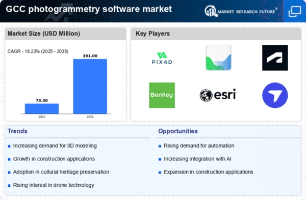
As per MRFR analysis, the GCC Photogrammetry Software Market Size was estimated at 73.44 (USD Million) in 2023.The GCC Photogrammetry Software Market is expected to grow from 86.8(USD Million) in 2024 to 247 (USD Million) by 2035. The GCC Photogrammetry Software Market CAGR (growth rate) is expected to be around 9.974% during the forecast period (2025 - 2035).

Key GCC Photogrammetry Software Market Trends Highlighted

The market for photogrammetry software in the GCC is expanding significantly due to the quick development of infrastructure projects throughout the area. Governments in nations like Saudi Arabia and the United Arab Emirates are making significant investments in urban development projects and smart cities, where photogrammetry is essential for mapping and surveying.

The utilization of cutting-edge technology in the construction industry, especially drones for aerial surveying, which improves project planning and execution accuracy and efficiency, is a major market driver. Further driving the adoption of photogrammetry software is the increasing need for 3D modeling and visualization across a range of industries, such as mining, real estate, and agriculture.

In order to produce more comprehensive and educational datasets, there has been a recent surge in interest in combining photogrammetry with geographic information systems (GIS). This tendency positions photogrammetry software as a crucial tool for decision-makers and is in line with the GCC's goals to use digital technology in governance and urban planning.

Additionally, there are chances to investigate cutting-edge uses of photogrammetry in fields like environmental monitoring and cultural heritage preservation as the GCC nations continue to diversify their economies away from reliance on oil.

Cloud-based photogrammetry solutions have also grown in popularity as a result of the continuous trend toward remote work and virtual collaboration, which has been sped up by recent global issues. In addition to improving accessibility, these advancements facilitate cross-stakeholder collaboration on projects, which boosts workflow efficiency.The market for photogrammetry software is expected to expand as the GCC shifts to technology-driven procedures, serving a wide range of sectors seeking to use spatial data to make well-informed decisions.

GCC Photogrammetry Software Market size

Source: Primary Research, Secondary Research, MRFR Database and Analyst Review

Growing Demand for Infrastructure Development in GCC

The GCC Photogrammetry Software Market is experiencing significant growth due to the increasing demand for advanced infrastructure development across the Gulf Cooperation Council region.

Governments in GCC countries, including Saudi Arabia and the United Arab Emirates, have initiated numerous mega-projects as part of their Vision 2030 and similar national strategies, aiming to diversify their economies away from oil dependence. According to the Saudi Arabian Ministry of Transport, the total investment planned for the transport sector alone exceeds 100 billion USD over the next decade.

This surge in infrastructure projects not only drives the need for precise mapping and surveying but also cultivates a growing market for photogrammetry software, which is essential for accurate land surveys and project planning. Companies like ESRI and Autodesk are increasingly providing solutions tailored for these large-scale developments, thus fueling demand within the GCC Photogrammetry Software Market.

Increasing Adoption of Drones for Surveying Purposes

The adoption of drone technology for surveying and mapping has significantly enhanced the capabilities of photogrammetry in the GCC region. The National Civil Aviation Authority in the UAE has noted a rapid increase in drone usage for commercial applications, with licenses issued rising by over 350% in the last five years.

Drones equipped with photogrammetry software provide efficiency and cost-effectiveness in capturing high-resolution images and data for various industries, including construction, agriculture, and urban planning.

Notably, organizations like the UAE's Al Ain Municipality are leveraging drone technology for urban planning and development, thereby propelling the growth of the GCC Photogrammetry Software Market.

Rising Popularity of 3D Mapping Solutions

As urbanization continues to proliferate in the GCC region, the demand for 3D mapping solutions is on the rise. Cities like Doha and Riyadh are rapidly expanding, necessitating advanced mapping capabilities to manage urban planning and development. The Qatar National Development Strategy has pointed towards an increased investment in advanced mapping technologies to address urban challenges.

Additionally, the Kingdom of Saudi Arabia is focusing on smart city initiatives that require detailed geographical information systems, which rely heavily on photogrammetry software. Companies such as Bentley Systems and Pix4D are innovating their software solutions specifically for this growing need, thereby enhancing the growth trajectory of the GCC Photogrammetry Software Market.

Significant Investments in Research and Development (R&D)

Significant investments in Research and Development (R&D) within the photogrammetry sector are driving innovation and expansion in the GCC Photogrammetry Software Market.

The government of the United Arab Emirates, through initiatives such as the UAE National Innovation Strategy, aims to position the country as a global leader in technology and innovation, with intent to invest substantial funds over the coming years in advanced technologies including photogrammetry.

Recent reports indicate that UAE's R&D expenditure has seen a year-on-year growth of approximately 10%, which bolsters the competitive capabilities of local firms and attracts international players to enhance their offerings. Consequently, this influx of innovation is set to significantly impact the advancement and accessibility of photogrammetry solutions across the GCC region.

GCC Photogrammetry Software Market Segment Insights

Photogrammetry Software Market Photogrammetry Type Insights

The GCC Photogrammetry Software Market shows a robust and evolving landscape with a focus on the Photogrammetry Type segment. This segment encompasses various methodologies that are essential for capturing and analyzing spatial data, each with its unique applications and significance within the region.

Aerial Photogrammetry is particularly highlighted due to its comprehensive use in mapping, surveying, and infrastructure development, driven by the rapid urbanization and construction projects in GCC countries. Terrestrial Photogrammetry, on the other hand, is gaining traction among industries such as oil and gas, where precise ground-level data collection is necessary for planning and maintenance tasks.

Close-Range Photogrammetry caters to specialized applications such as cultural heritage documentation and manufacturing, providing high-resolution data for detail-oriented projects.Satellite Photogrammetry is critical in the GCC, serving agricultural, environmental monitoring, and urban planning needs, particularly with vast desert expanses that require remote sensing techniques for effective resource management.

Underwater Photogrammetry is emerging as a vital tool for marine conservation efforts and underwater archaeological surveys, identifying the growing intersection of technology and environmental sustainability within the region.Other methodologies within the Photogrammetry Type segment contribute to niche applications, showcasing the diverse needs and challenges of various sectors in the GCC. Overall, this segment reflects the dynamic advancements in technology, emphasizing the increasing importance of accurate geospatial data in shaping future development across the GCC.

The market growth is further propelled by the government initiatives aiming to digitize and modernize infrastructure, alongside an increasing demand for high-resolution imagery and detailed spatial analysis.The GCC Photogrammetry Software Market holds significant potential as industries leverage these various photogrammetry methods to enhance decision-making processes and improve operational efficiencies.

GCC Photogrammetry Software Market Segment

Source: Primary Research, Secondary Research, MRFR Database and Analyst Review

Photogrammetry Software Market Deployment Mode Insights

The Deployment Mode segment of the GCC Photogrammetry Software Market is primarily categorized into On-premises and Cloud-based solutions, both of which offer distinct advantages that cater to various user needs.

On-premises solutions provide organizations with robust data security and control over sensitive information, making them a popular choice for industries with stringent regulatory requirements. In contrast, Cloud-based platforms have gained traction for their scalability and ease of access, enabling users to collaborate in real time without significant infrastructure investment.

The shift towards Cloud-based solutions is particularly evident in the GCC region, driven by the growing adoption of digital transformation initiatives by both government and private sectors. This segment is beneficial as it allows for rapid deployment and flexible licensing options.

As organizations in the GCC prioritize operational efficiency and cost-effectiveness, the demand for both deployment modes is expected to evolve, reflecting a balance between the need for security and the advantages of cloud computing.The landscape of the GCC Photogrammetry Software Market continues to be influenced by emerging technologies, increasing investment in infrastructure, and a rising awareness of the benefits of photogrammetry applications across various sectors, including construction, urban planning, and environmental monitoring.

Photogrammetry Software Market Pricing Model Insights

The Pricing Model segment of the GCC photogrammetry software market highlights significant insights into the dynamics of commercial/proprietary software and open-source software. Commercial/proprietary software is crucial for organizations in the GCC region that seek reliable support and comprehensive features integrated into their photogrammetry applications.This type of software typically commands a higher price point, but it offers robust performance, regular updates, and security assurances that are vital in sectors such as construction, surveying, and environmental monitoring.

In contrast, Open-Source Software presents an appealing alternative for many users, especially small businesses and educational institutions, given its cost-effectiveness and customizable nature. This model fosters innovation and collaboration, allowing users to tailor the software to their specific needs.

The growing demand for photogrammetry in urban planning and infrastructure projects in the GCC fuels this trend. As countries in the GCC prioritize technological advancements and data-driven decision-making, both segments within the Pricing Model are positioned to play complementary roles in the market’s expansion, catering to varying budgets and requirements.

Photogrammetry Software Market End Use Vertical Insights

The GCC Photogrammetry Software Market is witnessing substantial growth due to its diverse applications across various end use verticals. The Architecture, Engineering, and Construction (AEC) sector is becoming increasingly reliant on photogrammetry for enhancing project accuracy and efficiency, thereby facilitating effective resource management.

Surveying and Mapping significantly benefit from photogrammetry’s precision, enabling accurate data collection for infrastructure development and urban planning. In the Mining and Natural Resources domain, this technology assists in conducting geological assessments and resource management, further driving sector advancements.

The Oil and Gas industry employs photogrammetry for pipeline inspection and environmental monitoring, crucial for operational safety and compliance. Agriculture and Forestry sectors utilize this software for crop monitoring and land management, as it supports sustainable practices through precise data analytics.Cultural Heritage and Archaeology benefit from photogrammetry by enabling detailed documentation and preservation efforts in heritage sites. Defense and Security utilize this technology for reconnaissance and surveillance applications, enhancing strategic planning.

The Manufacturing and Industrial vertical leverages photogrammetry for process optimization, while the Film, Animation, and Gaming industries harness it to create realistic visuals and immersive experiences. Finally, Research and Education sectors adopt photogrammetry for experimental data collection and teaching methodologies, reflecting its wide-ranging applicability within the GCC region.

GCC Photogrammetry Software Market Key Players and Competitive Insights

The GCC Photogrammetry Software Market is characterized by rapid advancements and increasing demand driven by various sectors including construction, surveying, urban planning, and environmental monitoring.

As countries in the Gulf Cooperation Council invest in infrastructure developments and smart city initiatives, the need for high-resolution mapping and geospatial data has heightened, leading to an intense competitive landscape.

The market features a blend of established providers and emerging players, each vying for market share by offering innovative solutions tailored to regional needs. Factors such as technological advancements, strategic partnerships, and the emphasis on precision in data collection play a pivotal role in shaping the competitive dynamics of this sector.

Key Companies in the GCC Photogrammetry Software Market Include:

  • Pix4D
  • DroneDeploy
  • Trimble
  • Esri
  • Autodesk
  • Skycatch
  • Bentley Systems

GCC Photogrammetry Software Market Developments

Companies including Pix4D, DroneDeploy, Trimble, Esri, Autodesk, and Bentley Systems were identified as important participants in the GCC/MENA region photogrammetry software ecosystem in a March 2023 Middle East photogrammetry industry research.

Due to their comparable performance and user-friendliness in regional projects, Reddit users in the drone mapping community (who frequently operate in GCC environments) later confirmed Pix4D and DroneDeploy as the preferred choices for UAV-based mapping workflows in February 2025.

Trimble increased regional survey adoption by about 20% in 2024 by introducing drone-integrated photogrammetry advancements that supported use cases in construction and agriculture in GCC countries.

With Autodesk ReCap being utilized more frequently in architecture digital twin projects and Esri's ArcGIS being integrated into utility mapping in the United Arab Emirates and Saudi Arabia, Autodesk and Esri products have continued to be integrated into GCC AEC workflows.

Through extensive infrastructure modeling projects (such as telecom towers and airports), Bentley's ContextCapture became well-known in the GCC's efforts to establish digital twins. Skycatch was frequently mentioned as a new drone-based mapping platform in the Middle East in regional software market previews.

According to these advances, as of mid-2025, the most well-known and frequently used photogrammetry software platforms in the GCC are Pix4D, DroneDeploy, Trimble, Autodesk, Esri, Bentley, and Skycatch.

GCC Photogrammetry Software Market Segmentation Insights

Photogrammetry Software Market Photogrammetry Type Outlook

  • Aerial Photogrammetry
  • Terrestrial Photogrammetry
  • Close-Range Photogrammetry
  • Satellite Photogrammetry
  • Underwater Photogrammetry
  • Others

Photogrammetry Software Market Deployment Mode Outlook

  • On-premises
  • Cloud-based

Photogrammetry Software Market Pricing Model Outlook

  • Commercial/Proprietary Software
  • Open-Source Software

Photogrammetry Software Market End Use Vertical Outlook

  • Architecture
  • Engineering
  • Construction (AEC)
  • Surveying and Mapping
  • Mining and Natural Resources
  • Oil and Gas
  • Agriculture and Forestry
  • Cultural Heritage and Archaeology
  • Defense and Security
  • Manufacturing and Industrial
  • Film
  • Animation
  • Gaming
  • Research And Education
 
Report Attribute/Metric Source: Details
MARKET SIZE 2023 73.44(USD Million)
MARKET SIZE 2024 86.8(USD Million)
MARKET SIZE 2035 247.0(USD Million)
COMPOUND ANNUAL GROWTH RATE (CAGR) 9.974% (2025 - 2035)
REPORT COVERAGE Revenue Forecast, Competitive Landscape, Growth Factors, and Trends
BASE YEAR 2024
MARKET FORECAST PERIOD 2025 - 2035
HISTORICAL DATA 2019 - 2024
MARKET FORECAST UNITS USD Million
KEY COMPANIES PROFILED SimActive, Mappi, Pix4D, DroneDeploy, Aibotix, Geosoft, Trimble, Gexcel, Esri, Autodesk, RapidEye, Airbus, Skycatch, Bentley Systems, Maptek
SEGMENTS COVERED Photogrammetry Type, Deployment Mode, Pricing Model, End Use Vertical
KEY MARKET OPPORTUNITIES Increased demand in construction projects, Growth in aerial surveying applications, Adoption of GIS technologies, Expansion of urban planning initiatives, Rising interest in 3D mapping solutions
KEY MARKET DYNAMICS Rising demand for 3D mapping, Increased use in urban planning, Growth in construction projects, Advancements in drone technology, Need for accurate data visualization
COUNTRIES COVERED GCC


Frequently Asked Questions (FAQ) :

The expected market size of the GCC Photogrammetry Software Market in 2024 is 86.8 USD Million.

By 2035, the projected market value of the GCC Photogrammetry Software Market is 247.0 USD Million.

The expected CAGR for the GCC Photogrammetry Software Market from 2025 to 2035 is 9.974%.

In 2024, Satellite Photogrammetry is valued the highest at 25.0 USD Million.

The expected market value for Aerial Photogrammetry in 2035 is 57.0 USD Million.

Major players in the GCC Photogrammetry Software Market include SimActive, Pix4D, DroneDeploy, and Esri.

Terrestrial Photogrammetry is expected to grow from 18.0 USD Million in 2024 to 52.0 USD Million in 2035.

The market for Close-Range Photogrammetry in 2024 is significant at 12.0 USD Million.

Challenges such as technological advancements and regulatory changes could impact the GCC Photogrammetry Software Market growth.

Emerging opportunities in the GCC Photogrammetry Software Market include advancements in aerial imaging technology and increased demand from the construction sector.

Comments

Leading companies partner with us for data-driven Insights.

clients

Kindly complete the form below to receive a free sample of this Report

We do not share your information with anyone. However, we may send you emails based on your report interest from time to time. You may contact us at any time to opt-out.

Tailored for You
  • Dedicated Research on any specifics segment or region.
  • Focused Research on specific players in the market.
  • Custom Report based only on your requirements.
  • Flexibility to add or subtract any chapter in the study.
  • Historic data from 2014 and forecasts outlook till 2040.
  • Flexibility of providing data/insights in formats (PDF, PPT, Excel).
  • Provide cross segmentation in applicable scenario/markets.
report-img