info@marketresearchfuture.com   📞 +1 (855) 661-4441(US)   📞 +44 1720 412 167(UK)   📞 +91 2269738890(APAC)
Certified Global Research Member
Isomar 1 Iso 1
Key Questions Answered
  • Global Market Outlook
  • In-depth analysis of global and regional trends
  • Analyze and identify the major players in the market, their market share, key developments, etc.
  • To understand the capability of the major players based on products offered, financials, and strategies.
  • Identify disrupting products, companies, and trends.
  • To identify opportunities in the market.
  • Analyze the key challenges in the market.
  • Analyze the regional penetration of players, products, and services in the market.
  • Comparison of major players financial performance.
  • Evaluate strategies adopted by major players.
  • Recommendations
Why Choose Market Research Future?
  • Vigorous research methodologies for specific market.
  • Knowledge partners across the globe
  • Large network of partner consultants.
  • Ever-increasing/ Escalating data base with quarterly monitoring of various markets
  • Trusted by fortune 500 companies/startups/ universities/organizations
  • Large database of 5000+ markets reports.
  • Effective and prompt pre- and post-sales support.

Europe Photogrammetry Software Market Research Report By Photogrammetry Type (Aerial Photogrammetry, Terrestrial Photogrammetry, Close-Range Photogrammetry, Satellite Photogrammetry, Underwater Photogrammetry, Others), By Deployment Mode (On-premises, Cloud-based), By Pricing Model (Commercial/Proprietary Software, Open-Source Software), By End Use Vertical (Architecture, Engineering, Construction (AEC), Surveying and Mapping, Mining and Natural Resources, Oil and Gas, Agriculture and Forestry, Cultural Heritage and Archaeology, Defense and


ID: MRFR/ICT/60067-HCR | 200 Pages | Author: Aarti Dhapte| August 2025

Europe Photogrammetry Software Market Overview

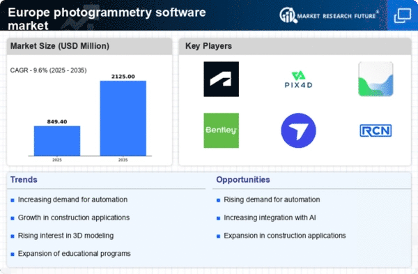
As per MRFR analysis, the Europe Photogrammetry Software Market Size was estimated at 655.67 (USD Million) in 2023.The Europe Photogrammetry Software Market is expected to grow from 775(USD Million) in 2024 to 4,830.35 (USD Million) by 2035. The Europe Photogrammetry Software Market CAGR (growth rate) is expected to be around 18.098% during the forecast period (2025 - 2035).

Key Europe Photogrammetry Software Market Trends Highlighted

The use of photogrammetry technologies is being further stimulated by European governments' push for sustainable planning and smart city initiatives. There are opportunities to investigate when combining photogrammetry with other technologies, such as artificial intelligence and drone technology.

The potential for effective data processing and analysis grows as aerial mapping and data collection techniques advance. The use of photogrammetry in the administration and protection of cultural heritage has become more popular in Europe in recent years.

With support from both governmental and non-governmental organizations, some European nations are using 3D modeling to repair historic sites. Remote sensing and photogrammetry are becoming increasingly popular as a result of businesses' growing emphasis on Environmental, Social, and Governance (ESG) standards in order to conduct more accurate environmental evaluations.

Additionally, photogrammetry software is becoming easier to use and more affordable due to the growth of cloud-based solutions, which allows small and medium-sized businesses to implement these technologies without having to make large infrastructure investments.Policies encouraging innovation and research in photogrammetry will probably open up new growth opportunities in the region as the European Union works to fortify its digital economy, indicating a bright future for the business.

Europe Photogrammetry Software Market size

Source: Primary Research, Secondary Research, MRFR Database and Analyst Review

Europe Photogrammetry Software Market Drivers

Increased Demand for Precision in Mapping and Surveying

The Europe Photogrammetry Software Market is witnessing a robust increase in demand for high-precision mapping and surveying solutions. In countries like Germany and France, advancements in geographic information systems (GIS) and digital terrain models are driving this trend.

According to the European Commission's Digital Economy and Society Index (DESI), over 50% of small and medium enterprises report the use of advanced digital technologies, impacting the mapping sector significantly.

Moreover, organizations like the European Environment Agency (EEA) emphasize the importance of precise geospatial data for environmental assessments and urban planning. As urbanization accelerates in Europe, particularly in metropolitan areas, the demand for accurate geographic data continues to rise, propelling the growth of the photogrammetry software market across the region.

Technological Advancements in Drone Technology

The integration of drone technology with photogrammetry software is transforming the landscape of aerial surveying and mapping in Europe. With regulations supporting UAV (Unmanned Aerial Vehicle) operations coming into effect across several European countries, including the United Kingdom and Spain, the market is poised for substantial growth.

In 2020, the European Union Aviation Safety Agency (EASA) reported a rise in the registration of drones, reaching approximately 50,000 by the end of the year, showcasing heightened interest and capability in aerial imaging. This shift towards drone-enhanced photogrammetry allows for faster data collection and improved accuracy, catering to sectors like construction, agriculture, and environmental monitoring.

Growing Need for 3D Visualization in Various Industries

There is an escalating need for 3D visualization and modeling across industries in Europe, particularly in real estate, construction, and engineering. The European Union has highlighted the importance of adopting digital tools for enhancing operational efficiency and project transparency.

For instance, a report from the European Construction Industry Federation indicates that over 70% of construction projects are moving towards Building Information Modeling (BIM), which relies heavily on photogrammetry for accurate site assessments.As companies strive for improved design accuracy and communication, the reliance on advanced imaging technologies like photogrammetry is expected to rise significantly in the region.

Europe Photogrammetry Software Market Segment Insights

Photogrammetry Software Market Photogrammetry Type Insights

The Europe Photogrammetry Software Market is witnessing significant advancement driven by various technologies and applications across different types of photogrammetry.The Aerial Photogrammetry segment, which is heavily utilized in urban planning, agriculture, and environmental monitoring, plays an essential role in data collection for large-scale projects and provides a bird's-eye view that is critical for effective land management and topographical mapping.

Meanwhile, Terrestrial Photogrammetry is increasingly important for architectural and heritage conservation, enabling detailed documentation and preservation of historical structures, and acts as a primary tool for the construction industry in site surveying.

Close-Range Photogrammetry is gaining traction as it allows for precise measurements and modeling of small objects and is widely used in industries such as manufacturing and forensic science, providing high-resolution data for accurate analysis.Satellite Photogrammetry offers unique advantages by enabling global coverage and monitoring capabilities, making it invaluable for environmental studies, disaster response, and land use assessments.

The Underwater Photogrammetry segment is emerging as a crucial element, particularly in marine research and conservation efforts, facilitating detailed analysis of underwater ecosystems and supporting industries such as oil and gas exploration.Other segments contribute to the overall innovation landscape in photogrammetry by integrating various technologies, such as drones and artificial intelligence, to enhance accuracy and efficiency across applications.

As the need for mapping and monitoring continues to grow in Europe, these different types of photogrammetry collectively address diverse challenges in several sectors, supporting economic growth and infrastructural development.Additionally, various government initiatives aimed at bolstering technology adoption and funding, along with increasing investments in Research and Development, are providing substantial opportunities for the expansion and evolution of the Photogrammetry Software Market in the region, further enhancing its significance.

Europe Photogrammetry Software Market Segment

Source: Primary Research, Secondary Research, MRFR Database and Analyst Review

Photogrammetry Software Market Deployment Mode Insights

The Deployment Mode segment of the Europe Photogrammetry Software Market illustrates a dynamic landscape, with both On-premises and Cloud-based solutions playing pivotal roles.On-premises deployment is often favored by organizations that require tighter control over their data and computational resources, such as governmental agencies and large enterprises that prioritize data security and customization.

This mode of deployment allows these users to maintain their software on local servers, resulting in faster processing times, especially for complex data sets typical in photogrammetry applications. Conversely, Cloud-based solutions are gaining traction due to their flexibility, scalability, and cost-effectiveness, making them particularly appealing for small to medium-sized enterprises and remote teams.

With advancements in internet technology and increased trust in data security protocols, many businesses in Europe are transitioning to Cloud-based platforms, enabling easier collaboration and access to software updates.

Overall, the choice between these deployment modes reflects an organization's specific needs, resource availability, and strategic goals, shaping the future trajectory of the Europe Photogrammetry Software Market. This diversity in deployment preferences underscores the importance of tailoring software solutions to meet varying operational requirements across industries.

Photogrammetry Software Market Pricing Model Insights

The Europe Photogrammetry Software Market has evolved significantly, particularly within the Pricing Model segment, where the demand for both Commercial/Proprietary Software and Open-Source Software has seen notable attention.Commercial software typically offers robust support, exclusive features, and consistent updates, making it a preferred choice among enterprises that prioritize reliability and comprehensive service packages.

In contrast, Open-Source Software provides greater flexibility and cost efficiency, appealing to smaller companies and independent developers looking for customizable solutions without the constraints of licensing fees. This diversification in pricing models caters to a broader audience across various industries, including construction, mapping, and surveying.

As industries increasingly adopt photogrammetry technologies for enhanced data collection and analysis, these pricing models play a pivotal role in shaping not only user accessibility and satisfaction but also technological advancements within the market landscape.

With research and development initiatives accelerating innovation, the balancing act between cost and functionality in the Europe Photogrammetry Software Market remains crucial for driving growth and meeting diverse consumer needs. The landscape continues to adapt to emerging trends, thereby creating a dynamic environment ripe with opportunities for both providers and users in the region.

Photogrammetry Software Market End Use Vertical Insights

The End Use Vertical segment of the Europe Photogrammetry Software Market showcases a diverse range of applications that are integral to various industries, highlighting the versatility of photogrammetry technology.

In the Architecture, Engineering, and Construction (AEC) sector, the software enhances design accuracy and project management efficiency, which is vital for sustainable urban development in densely populated Europe. Surveying and Mapping utilizes photogrammetry for detailed topographical analysis, beneficial for planning infrastructure projects across the continent.

The Mining and Natural Resources sector leverages this technology for resource mapping and environmental monitoring, ensuring compliance with European Union regulations. In the Oil and Gas industry, photogrammetry aids in pipeline monitoring and site analysis, crucial for optimizing resource extraction and adherence to safety standards.

Agriculture and Forestry sectors benefit from photogrammetry for precision farming and forest inventory management, promoting sustainable practices. Cultural Heritage and Archaeology experts employ these tools for site documentation and preservation efforts.

Defense and Security applications include surveillance and tactical planning, in line with national security objectives. The Manufacturing and Industrial sectors use photogrammetry for quality control and process optimization, while the Film, Animation, and Gaming industries harness these technologies to create realistic environments.

Research and Education institutions leverage photogrammetry to support innovative learning experiences and scholarly projects, reflecting the significant impact of this segment on various fields.Overall, the End Use Vertical in the Europe Photogrammetry Software Market illustrates a growing demand driven by technological advancements and regulatory compliance, emphasizing the software’s relevance and expanding importance across multiple sectors.

Photogrammetry Software Market Regional Insights

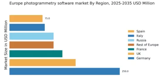
The Europe Photogrammetry Software Market exhibits robust growth across various countries, reflecting the increasing demand for geospatial technology and mapping solutions. Germany holds a significant position in the market due to its advanced industrial base and high adoption rates of digital technologies, especially in urban planning and infrastructure development.

The UK follows closely, driven by its vibrant Research and Development ecosystem that fosters innovation in photogrammetry applications. France contributes through its emphasis on heritage preservation and environmental monitoring, highlighting the software's versatility.Russia, with its focus on vast geographical terrains, utilizes photogrammetry for resource management and cartography, while Italy leverages the technology for artistic and architectural documentation, showcasing its cultural heritage.

Spain and the Rest of Europe are also notable contributors, with growing interest in agricultural mapping and land surveying. This diversity in application across regions underlines the Europe Photogrammetry Software Market's segmentation dynamics, where each country brings unique growth drivers and opportunities, reflecting the technology's increasing relevance in various sectors.

The market's expansion is further supported by favorable government initiatives aimed at promoting digital transformation within regional industries, enhancing the overall landscape of photogrammetry software utilization in Europe.

Europe Photogrammetry Software Market Region

Source: Primary Research, Secondary Research, MRFR Database and Analyst Review

Europe Photogrammetry Software Market Key Players and Competitive Insights

The Europe Photogrammetry Software Market is characterized by a dynamic landscape where innovation and advancement drive competition among various players. This market has witnessed significant growth due to the increasing demand for precise mapping, surveying, and 3D modeling applications across multiple industries such as construction, urban planning, and environmental monitoring.

Companies are focusing on enhancing their product offerings and integrating advanced technologies like artificial intelligence and machine learning into their photogrammetry solutions.

Competitive insights reveal that market participants are not only competing on product capabilities but also on customer service, pricing strategies, and regional presence which are critical in capturing larger market shares within this economically diverse region.

Key Companies in the Europe Photogrammetry Software Market Include:

  • Pix4D
  • DroneDeploy
  • Capturing Reality
  • Hexagon AB
  • Trimble
  • Esri
  • Autodesk
  • RealityCapture
  • Bentley Systems
  • Agisoft

Europe Photogrammetry Software Market Developments

Skyline Software Systems and Drone Harmony established a partnership in February 2023, providing comprehensive capture-to-3D-model inspection workflows specifically designed for European UAV operations.

In the meantime, Capturing Reality, the company that creates RealityCapture, changed its pricing in April 2024 under the ownership of Epic Games. This made RealityCapture free for developers with gross revenue under $1 million USD, significantly increasing accessibility for small studios and developers in Europe.

Pix4D continued to hold a commanding lead in Europe throughout 2023–2025 and was regularly mentioned in academic settings in drone mapping courses. In April 2024, RealityCapture attracted fresh interest in forums due to its enhanced cost model, quickness, and quality.

For digital twin, infrastructure, and survey-grade applications, European user groups and infrastructure companies remained loyal to Bentley Systems’ ContextCapture, Trimble, Esri, and Autodesk ReCap in 2025. Though less common than comprehensive photogrammetry platforms, open-source solutions like CloudCompare are nonetheless widely used for point-cloud analysis in research contexts.Today, the most active and extensively used photogrammetry software suppliers in Europe are Pix4D, RealityCapture, Bentley Systems (ContextCapture), Trimble, Autodesk, Esri, and Agisoft.

Europe Photogrammetry Software Market Segmentation Insights

Photogrammetry Software Market Photogrammetry Type Outlook

    • Aerial Photogrammetry
    • Terrestrial Photogrammetry
    • Close-Range Photogrammetry
    • Satellite Photogrammetry
    • Underwater Photogrammetry
    • Others

Photogrammetry Software Market Deployment Mode Outlook

    • On-premises
    • Cloud-based

Photogrammetry Software Market Pricing Model Outlook

    • Commercial/Proprietary Software
    • Open-Source Software

Photogrammetry Software Market End Use Vertical Outlook

    • Architecture
    • Engineering
    • Construction (AEC)
    • Surveying and Mapping
    • Mining and Natural Resources
    • Oil and Gas
    • Agriculture and Forestry
    • Cultural Heritage and Archaeology
    • Defense and Security
    • Manufacturing and Industrial
    • Film
    • Animation
    • Gaming
    • Research And Education

Photogrammetry Software Market Regional Outlook

    • Germany
    • UK
    • France
    • Russia
    • Italy
    • Spain
    • Rest of Europe
 
Report Attribute/Metric Source: Details
MARKET SIZE 2023 655.67(USD Million)
MARKET SIZE 2024 775.0(USD Million)
MARKET SIZE 2035 4830.35(USD Million)
COMPOUND ANNUAL GROWTH RATE (CAGR) 18.098% (2025 - 2035)
REPORT COVERAGE Revenue Forecast, Competitive Landscape, Growth Factors, and Trends
BASE YEAR 2024
MARKET FORECAST PERIOD 2025 - 2035
HISTORICAL DATA 2019 - 2024
MARKET FORECAST UNITS USD Million
KEY COMPANIES PROFILED MSS Software, 1Spatial, Pix4D, DroneDeploy, Geospatial Systems, Capturing Reality, Hexagon AB, Trimble, Esri, Autodesk, RealityCapture, Bentley Systems, Visual3D, CloudCompare, Agisoft
SEGMENTS COVERED Photogrammetry Type, Deployment Mode, Pricing Model, End Use Vertical, Regional
KEY MARKET OPPORTUNITIES Growing demand in construction, Adoption in agricultural mapping, Expansion of 3D modeling applications, Integration with drone technology, Increasing use in cultural heritage preservation
KEY MARKET DYNAMICS growing demand for 3D modeling, increased adoption in construction, advancements in UAV technology, rising interest in geospatial analysis, expansion of AR/VR applications
COUNTRIES COVERED Germany, UK, France, Russia, Italy, Spain, Rest of Europe


Frequently Asked Questions (FAQ) :

The Europe Photogrammetry Software Market is expected to be valued at 775.0 million USD in 2024.

By 2035, the market is expected to reach a valuation of 4830.35 million USD.

The expected CAGR for the market during this period is 18.098%.

Germany is projected to hold the largest market share with a value of 200.0 million USD in 2024.

The market for Terrestrial Photogrammetry is expected to be valued at 1200.0 million USD in 2035.

Major players in the market include MSS Software, 1Spatial, Pix4D, DroneDeploy, and Esri.

Aerial Photogrammetry is expected to have a market value of 300.0 million USD in 2024.

The UK is expected to grow significantly, with a forecasted market value of 900.0 million USD in 2035.

In 2035, the market for Underwater Photogrammetry is expected to reach 330.35 million USD.

Key applications include construction, agriculture, mapping, and environmental monitoring.

Comments

Leading companies partner with us for data-driven Insights.

clients

Kindly complete the form below to receive a free sample of this Report

We do not share your information with anyone. However, we may send you emails based on your report interest from time to time. You may contact us at any time to opt-out.

Tailored for You
  • Dedicated Research on any specifics segment or region.
  • Focused Research on specific players in the market.
  • Custom Report based only on your requirements.
  • Flexibility to add or subtract any chapter in the study.
  • Historic data from 2014 and forecasts outlook till 2040.
  • Flexibility of providing data/insights in formats (PDF, PPT, Excel).
  • Provide cross segmentation in applicable scenario/markets.
report-img