info@marketresearchfuture.com   📞  +1 (855) 661-4441(US)   📞  +44 1720 412 167(UK)
Certified Global Research Member
Isomar fd.webp Wcrc 57.webp
Key Questions Answered
  • Global Market Outlook
  • In-depth analysis of global and regional trends
  • Analyze and identify the major players in the market, their market share, key developments, etc.
  • To understand the capability of the major players based on products offered, financials, and strategies.
  • Identify disrupting products, companies, and trends.
  • To identify opportunities in the market.
  • Analyze the key challenges in the market.
  • Analyze the regional penetration of players, products, and services in the market.
  • Comparison of major players financial performance.
  • Evaluate strategies adopted by major players.
  • Recommendations
Why Choose Market Research Future?
  • Vigorous research methodologies for specific market.
  • Knowledge partners across the globe
  • Large network of partner consultants.
  • Ever-increasing/ Escalating data base with quarterly monitoring of various markets
  • Trusted by fortune 500 companies/startups/ universities/organizations
  • Large database of 5000+ markets reports.
  • Effective and prompt pre- and post-sales support.

Drone GIS Mapping Market Research Report By Technology (Lidar, Photogrammetry, Radar, Thermal Imaging, Multispectral Imaging), By Mapping Type (Orthomosaics, Digital Surface Models, Terrain Models, Contour Lines, 3D Models), By Application (Surveying and Mapping, Construction, Agriculture, Environmental Monitoring, Disaster Response), By Platform (Fixed-Wing Drones, Rotary-Wing Drones, Hybrid Drones), By End-User (Government Agencies, Private Companies, Non-Profit Organizations, Academic Institutions, Individual Users) and By Regional (Nor


ID: MRFR/A&D/28030-HCR | 128 Pages | Author: Sejal Akre| December 2024

Global Drone GIS Mapping Market Overview


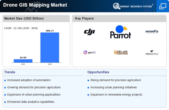
Drone GIS Mapping Market Size was estimated at 23.6 (USD Billion) in 2022. The Drone GIS Mapping Market Industry is expected to grow from 28.82(USD Billion) in 2023 to 174.32 (USD Billion) by 2032. The Drone GIS Mapping Market CAGR (growth rate) is expected to be around 22.14% during the forecast period (2024 - 2032).Drone_Gis_Mapping_Market_1


Source Primary Research, Secondary Research, MRFR Database and Analyst Review


Key Drone GIS Mapping Market Trends Highlighted


Key market drivers include advancements in drone technology, increasing demand for accurate and timely geospatial data, and growing adoption in various sectors such as construction, agriculture, and environmental monitoring.


Opportunities for growth lie in the integration of artificial intelligence and machine learning to automate data processing and analysis, the development of new applications and software, and the expansion into emerging markets.Recent trends include the adoption of multi-rotor drones with high-resolution cameras for improved data capture, the integration of thermal imaging for infrastructure inspection, and the use of drones for 3D modeling and volumetric calculations. These advancements enhance accuracy, efficiency, and the scope of applications for drone GIS mapping.


Drone GIS Mapping Market Drivers


Technological Advancements in Drone GIS Mapping


The Drone GIS Mapping Market is expected to show significant rise in the upcoming years, given the presence of numerous market drivers. One of the leading factors is the rapid development and growth of technologies that are used in drones, which, in turn, facilitate GIS mapping. High-resolution cameras, advanced sensors, and sophisticated software algorithms allow capturing extremely detailed imagery. Moreover, with the use of drones, it becomes possible to take aerial photographs and obtain data for very different areas.In this way, the progress in technology significantly changes and enhances GIS mapping, making it more efficient, cheap, and available for many purposes.


Growing Demand for Geospatial Data


The constantly growing demand for geospatial data is one more principal factor boosting the development of the Drone GIS Mapping Market. Geospatial data provides information about the land surface, its relief, infrastructure, and environmental conditions, allowing decision-makers to plan various activities, such as urban development, natural resource use, or agriculture product processing in the most optimal way. A drone power-driven with the help of GIS devices will be able to collect such information faster and more efficiently – that is why the constantly growing demand for this data will lead to the further development of the sector under consideration.


Government Initiatives and Regulations


In addition to the aforementioned drivers, significant efforts and regulations aimed at driving the Drone GIS Mapping Market are also taking place. Governments around the world recognize the potential of this technology and, as a result, are making efforts to give it a firmer foothold in the market. Such efforts include funding to support R, creation of regulations that would make the use of drones feasible, and promotion of drone GIS mapping in various public sector applications. Overall, such regulations and efforts create a generally positive environment for the industry to grow.


Drone GIS Mapping Market Segment Insights


Drone GIS Mapping Market Technology Insights  


The technology segment of the Drone GIS Mapping Market holds immense potential, with each technology offering unique capabilities and applications. Lidar, Photogrammetry, Radar, Thermal Imaging, and Multispectral Imaging are prominent technologies in this segment, each contributing to the market's growth. Lidar (Light Detection and Ranging) technology utilizes laser pulses to collect highly accurate 3D mapping data. It excels in generating detailed terrain models, vegetation mapping, and infrastructure inspection. The market for Lidar-based drone mapping is projected to reach $10.536 billion by 2026, exhibiting a CAGR of 15.6%.Photogrammetry, a well-established technique, employs overlapping aerial images to create 3D models. It finds widespread use in surveying, mapping, and construction. The drone photogrammetry market is anticipated to expand at a CAGR of 12.5%, reaching $6.818 billion by 2026. Radar technology, known for its ability to penetrate through dense vegetation and operate in low-light conditions, is gaining traction in the drone mapping industry. The drone-based radar mapping market is expected to grow at a CAGR of 14.8%, reaching $4.648 billion by 2026.Thermal Imaging technology detects and visualizes heat patterns, enabling applications such as infrastructure inspection, energy audits, and search and rescue operations. The market for drone-based thermal imaging is projected to reach $3.719 billion by 2026, expanding at a CAGR of 13.4%. Multispectral Imaging, utilizing multiple spectral bands, captures data beyond the visible spectrum. This technology finds applications in precision agriculture, environmental monitoring, and disaster response. The market for drone-based multispectral imaging is projected to reach $3.099 billion by 2026, growing at a CAGR of 12.8%.These technologies continue to evolve, driven by advancements in sensor technology, data processing algorithms, and drone capabilities. The convergence of these technologies with cloud computing, artificial intelligence, and machine learning is further enhancing their potential, leading to the expansion of the Drone GIS Mapping MarketDrone_Gis_Mapping_Market_2


Source Primary Research, Secondary Research, MRFR Database and Analyst Review


Drone GIS Mapping Market Mapping Type Insights  


The Drone GIS Mapping Market is segmented into Orthomosaics, Digital Surface Models, Terrain Models, Contour Lines, and 3D Models based on Mapping Type. The Orthomosaics segment held the largest share of the market in 2023 and is projected to continue its dominance throughout the forecast period, owing to its wide adoption in various applications such as land surveying, urban planning, and agriculture. The Digital Surface Models segment is expected to witness a significant growth rate during the forecast period, driven by its increasing use in terrain analysis, flood modeling, and geospatial intelligence.The Terrain Models segment is also anticipated to witness a steady growth rate due to its applications in civil engineering, mining, and construction. The Contour Lines segment is projected to have a moderate growth rate, primarily driven by its use in topographic mapping and landform analysis. The 3D Models segment is expected to witness a relatively lower growth rate, owing to its limited applications in specific industries such as architecture, engineering, and construction.


Drone GIS Mapping Market Application Insights  


The Drone GIS Mapping Market is segmented into Surveying and Mapping, Construction, Agriculture, Environmental Monitoring, and Disaster Response. The Surveying and Mapping segment is expected to hold the largest market share during the forecast period. The growth of this segment can be attributed to the increasing use of drones for surveying and mapping applications in various industries, such as construction, mining, and agriculture. The Construction segment is also expected to witness significant growth during the forecast period, due to the rising demand for drones for construction site monitoring, progress tracking, and safety inspections.The Agriculture segment is expected to grow at a steady pace, driven by the increasing use of drones for crop monitoring, precision agriculture, and livestock management. The Environmental Monitoring segment is also expected to experience growth, as drones are increasingly being used for environmental monitoring applications, such as pollution monitoring, wildlife monitoring, and disaster response. The Disaster Response segment is expected to grow at a rapid pace, due to the increasing use of drones for disaster response applications, such as search and rescue operations, damage assessment, and relief efforts.


Drone GIS Mapping Market Platform Insights  


The Drone GIS Mapping Market segmentation based on Platform categorizes the market into Fixed-Wing Drones, Rotary-Wing Drones, and Hybrid Drones. In 2023, the Rotary-Wing Drones segment held the largest market share of around 65%, owing to their superior maneuverability and stability during mapping operations. Fixed-Wing Drones are expected to witness a significant growth rate during the forecast period 2024-2032, due to their ability to cover large areas quickly and efficiently. Hybrid Drones, which combine the advantages of both fixed-wing and rotary-wing drones, are also projected to gain traction in the coming years.The Drone GIS Mapping Market revenue for the Platform segment is estimated to reach USD 32.54 Billion by 2024, growing at a CAGR of 20.23% from 2023 to 2032.


Drone GIS Mapping Market End-User Insights  


The end-user segment of the Drone GIS Mapping Market is diverse, encompassing various entities that utilize drone GIS mapping technology for their specific applications. Government agencies are significant users, employing drones for tasks such as infrastructure inspection, land surveying, and disaster response. Private companies leverage drones for asset management, construction monitoring, and precision agriculture. Non-profit organizations utilize drones for humanitarian aid, environmental monitoring, and disaster relief efforts. Academic institutions employ drones for research and educational purposes, while individual users utilize drones for personal projects, photography, and recreational activities.As of 2023, the government agencies segment held the largest market share, owing to the increasing adoption of drones for public safety and security applications. The private companies segment is projected to witness significant growth in the coming years due to the rising demand for drones in industries such as construction, mining, and energy.


Drone GIS Mapping Market Regional Insights  


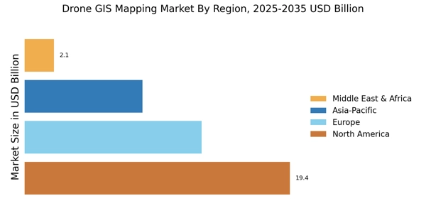
The Drone GIS Mapping Market is expected to witness significant growth over the forecast period. Regionally, North America is expected to dominate the market with a significant share of 10.646 billion USD, owing to the early adoption of advanced technologies, government initiatives, and presence of key players in the region. The Asia-Pacific region is projected to exhibit the highest growth rate due to the increasing demand for drones in mapping and surveying applications, rapid urbanization, and government support for infrastructure development, with a value of 5.172 billion USD. Europe holds a substantial market share of 9.651 billion USD due to the presence of well-established players and favorable regulatory policies.South America and MEA regions are anticipated to witness steady growth, driven by increasing investments in infrastructure projects and the adoption of drones for mapping and monitoring activities, with values of 1.676 billion USD and 1.676 billion USD respectively.Drone_Gis_Mapping_Market_3


Source Primary Research, Secondary Research, MRFR Database and Analyst Review


Drone GIS Mapping Market Key Players And Competitive Insights


Major players in Drone GIS Mapping Market industry are adapting various strategies like mergers, and acquisitions, partnerships and collaborations with other established players to expand their market presence and product portfolio. Top players are also investing in research and development activities to develop advanced and innovative solutions. Leading Drone GIS Mapping Market players are also focusing on strategic partnerships with key players in the ecosystem, such as hardware manufacturers, software developers, and service providers, to enhance their offerings and create a competitive edge. As a result of these strategies, the Drone GIS Mapping Market is expected to witness significant growth in the coming years.DJI, a leading player in the Drone GIS Mapping Market, is known for its innovative drone technology and comprehensive software solutions. The company offers a wide range of drones and mapping software that cater to the needs of various industries, including construction, agriculture, and mining. DJI's commitment to innovation and customer satisfaction has enabled it to maintain its position as a leader in the market. The company's strong brand recognition and presence also contribute to its competitive advantage.Another key player in the Drone GIS Mapping Market is senseFly, a Swiss company that specializes in mapping and surveying drones. senseFly's drones are known for their high-quality imagery and data collection capabilities. The company's software solutions are designed to provide users with accurate and detailed maps and models. senseFly's focus on innovation and customer support has helped it gain a strong reputation in the market. The company's strategic partnerships with industry leaders, such as Autodesk and Bentley Systems, further enhance its competitive position.


Key Companies in the Drone GIS Mapping Market Include


  • GeoCue Group

  • Measure

  • Terra Drone Corporation

  • Aerodyne Group

  • PrecisionHawk

  • Eagle Aerial Solutions

  • Kespry

  • Skydio

  • Wingtrao

  • Propeller Aero Solutions

  • Altavian

  • SlantRange

  • DJI

  • Cyberhawk

  • Airinov


Drone GIS Mapping Market Industry DevelopmentsThe integration of AI and machine learning algorithms into drone mapping software, enabling real-time data processing and enhanced accuracy. This has led to increased adoption in industries such as construction, mining, and agriculture.


Strategic partnerships between drone manufacturers and GIS software providers are driving innovation and expanding market reach. For instance, DJI's partnership with Esri allows for seamless integration of drone data into ArcGIS, a leading GIS platform.Growing demand for high-resolution aerial imagery and 3D mapping for infrastructure inspection, disaster response, and environmental monitoring is fueling market growth. Advancements in camera technology and data processing algorithms are meeting these demands.Government regulations and industry standards are being developed to ensure the safe and responsible use of drones for GIS mapping. This includes regulations on drone reGIStration, airspace management, and data privacy.Key market players are investing in research and development to enhance drone capabilities, such as longer flight times, improved obstacle avoidance, and increased payload capacity. These advancements are expected to further expand the scope of applications for drone GIS mapping.


Drone GIS Mapping Market Segmentation Insights


Drone GIS Mapping Market Technology Outlook


  • Lidar

  • Photogrammetry

  • Radar

  • Thermal Imaging

  • Multispectral Imaging


Drone GIS Mapping Market Mapping Type Outlook


  • Orthomosaics

  • Digital Surface Models

  • Terrain Models

  • Contour Lines

  • 3D Models


Drone GIS Mapping Market Application Outlook


  • Surveying and Mapping

  • Construction

  • Agriculture

  • Environmental Monitoring

  • Disaster Response


Drone GIS Mapping Market Platform Outlook


  • Fixed-Wing Drones

  • Rotary-Wing Drones

  • Hybrid Drones


Drone GIS Mapping Market End-User Outlook


  • Government Agencies

  • Private Companies

  • Non-Profit Organizations

  • Academic Institutions

  • Individual Users


Drone GIS Mapping Market Regional Outlook


  • North America

  • Europe

  • South America

  • Asia Pacific

  • Middle East and Africa


Drone GIS Mapping Market Report Scope

Report Attribute/Metric Details
Market Size 2022 23.6(USD Billion)
Market Size 2023 28.82(USD Billion)
Market Size 2032 174.32(USD Billion)
Compound Annual Growth Rate (CAGR) 22.14% (2024 - 2032)
Report Coverage Revenue Forecast, Competitive Landscape, Growth Factors, and Trends
Base Year 2023
Market Forecast Period 2024 - 2032
Historical Data 2019 - 2023
Market Forecast Units USD Billion
Key Companies Profiled GeoCue Group, Measure, Terra Drone Corporation, Aerodyne Group, PrecisionHawk, Eagle Aerial Solutions, Kespry, Skydio, Wingtrao, Propeller Aero Solutions, Altavian, SlantRange, DJI, Cyberhawk, Airinov
Segments Covered Technology, Mapping Type, Application, Platform, End-User, Regional
Key Market Opportunities Precision agriculture Infrastructure monitoring Environmental conservation Disaster management Mining and construction
Key Market Dynamics Increased demand for precision agriculture growing adoption of drones in construction advancements in drone technology rising environmental concerns government regulations and certifications
Countries Covered North America, Europe, APAC, South America, MEA


Frequently Asked Questions (FAQ) :

The Drone GIS Mapping market is estimated to be worth USD 28.82 billion in 2023.

The Drone GIS Mapping Market is projected to grow at a CAGR of 22.14% from 2024 to 2032.

North America is expected to hold the largest share of the Drone GIS Mapping market in 2023.

The infrastructure monitoring segment is expected to have the highest growth rate in the Drone GIS Mapping market.

Some of the key competitors in the Drone GIS Mapping market include DJI, Skydio, senseFly, and PrecisionHawk.

Some of the growth drivers for the Drone GIS Mapping market include the increasing adoption of drones for mapping and surveying, the growing demand for accurate and up-to-date geospatial data, and the increasing use of GIS technology in various industries.

Some of the challenges facing the Drone GIS Mapping market include the high cost of drones, the need for specialized skills to operate drones, and the regulatory restrictions on the use of drones in some areas.

The Drone GIS Mapping market is expected to reach USD 174.32 billion by 2032.

The Asia Pacific region is expected to have the highest growth rate in the Drone GIS Mapping market between 2024 and 2032.

Some of the key trends in the Drone GIS Mapping market include the increasing use of AI and machine learning in drones, the development of new drone technologies, and the growing adoption of drones in various industries.

Leading companies partner with us for data-driven Insights.

client_1 client_2 client_3 client_4 client_5 client_6 client_7 client_8 client_9 client_10

Kindly complete the form below to receive a free sample of this Report

Please fill in Business Email for Quick Response

We do not share your information with anyone. However, we may send you emails based on your report interest from time to time. You may contact us at any time to opt-out.

Purchase Option
Single User $ 4,950
Multiuser License $ 5,950
Enterprise User $ 7,250
Compare Licenses
Tailored for You
  • Dedicated Research on any specifics segment or region.
  • Focused Research on specific players in the market.
  • Custom Report based only on your requirements.
  • Flexibility to add or subtract any chapter in the study.
  • Historic data from 2014 and forecasts outlook till 2040.
  • Flexibility of providing data/insights in formats (PDF, PPT, Excel).
  • Provide cross segmentation in applicable scenario/markets.