info@marketresearchfuture.com   📞  +1 (855) 661-4441(US)   📞  +44 1720 412 167(UK)
Certified Global Research Member
Isomar fd.webp Wcrc 57.webp
Key Questions Answered
  • Global Market Outlook
  • In-depth analysis of global and regional trends
  • Analyze and identify the major players in the market, their market share, key developments, etc.
  • To understand the capability of the major players based on products offered, financials, and strategies.
  • Identify disrupting products, companies, and trends.
  • To identify opportunities in the market.
  • Analyze the key challenges in the market.
  • Analyze the regional penetration of players, products, and services in the market.
  • Comparison of major players financial performance.
  • Evaluate strategies adopted by major players.
  • Recommendations
Why Choose Market Research Future?
  • Vigorous research methodologies for specific market.
  • Knowledge partners across the globe
  • Large network of partner consultants.
  • Ever-increasing/ Escalating data base with quarterly monitoring of various markets
  • Trusted by fortune 500 companies/startups/ universities/organizations
  • Large database of 5000+ markets reports.
  • Effective and prompt pre- and post-sales support.

Aerial Imaging Market Research Report Information by Platform Type (Fixed-Wing Aircrafts, Helicopters, UAVs/Drones, and Others), Application (Land Surveying, Energy Equipment Monitoring, Agriculture, Public Safety and Inspection, and Defense), and Region (North America, Europe, Asia-Pacific, Middle East & Africa, and Latin America)—Forecast till 2030


ID: MRFR/A&D/9219-HCR | 174 Pages | Author: Swapnil Palwe| December 2024

Global Aerial Imaging Market Overview

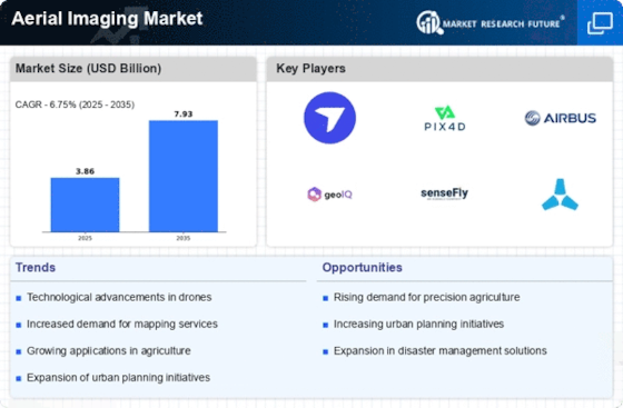
Aerial Imaging Market Size is expected to reach USD 8.52 Billion by 2030, registering a CAGR of 14.2% during 2020-2030.


Technological advancements such as the Internet of Things (IoT), LiDAR systems, GIS (geographic information system), and 360-degree vision cameras have bolstered the aerial imaging market. Unmanned aerial vehicles (UAVs) and drones are two instances of aerial imagery that are gaining traction in a variety of end-user sectors.


Aerial mapping of the terrain is critical for planning and implementing diverse tactics in a variety of applications, including forestry, coastal navigation, mining, oil and gas exploration, and disaster management. The use of GPS and inertial technology to generate a detailed and precise three-dimensional set of points or three-dimensional point cloud models has gained popularity in the world's industrial sectors.


Additionally, the aerial imaging market is seeing increased demand for a variety of applications from a variety of end-user sectors. Numerous uses include increased surveillance and monitoring, disaster management, geographic mapping, infrastructure development mapping capabilities, and assisting farmers in monitoring crops and identifying problems. As the aerial imaging market is still in its infancy, increasing demand for a variety of applications is projected to drive global growth.


News :


In January 2024, the manufacturing of hulls for October 2023: General Atomics Aeronautical Systems (GA-ASI) has announced the successful demonstration of their Aerial Recovery System, specifically designed for the mid-air launch and retrieval of tiny drones. The system was showcased on September 20, 2023, over Dugway Proving Ground in Utah. During the test, a towline was deployed and withdrawn from an Extended Range variant of a MQ-20 Avenger. This system will facilitate the launching and retrieval of tiny drones from larger UAVs while they are in the air. 


It is a crucial part of the company's overall concept for the various ways these aircraft can be used in future conflicts. The concept of the Aerial Recovery System for Small Unmanned Aircraft Systems/Air-Launched Effects (SUAS/ALE) is referred to as GA-ASI. The towline was equipped with a device known as a "smart end feature," which included a wireless connection to communicate with the bigger UAV. During the demonstration, the business integrated a hoist from Breeze-Eastern, equipped with GA-ASI's advanced smart end function, into the payload compartment of the Avenger aircraft. During the Avenger's flight, the towline was extended to the optimal distance for mid-air recovery.


COVID-19 Analysis


According to MRFR, the current projections of global aerial imaging market growth till 2027 are expected to be lower than pre-COVID-19 estimatesdue to a slight decline in the production of tools necessary for aerial imaging. However, COVID-19 has led to a surge in demand for aerial imaging tools, owing to their ability to get things done without any contact, and is expected to continue doing so for at least the next few years.


The aerial imaging industry has witnessed growth since the COVID-19 pandemic began. The integration of aerial imaging tools into the conventional systems for land surveying and inspection purposes has contributed significantly to the growth of the aerial imaging market during the COVID-19 outbreak. Aerial imaging has become essential in getting accurate surveying data to build modular hospitals for the victims. The surveying process is fast, efficient, and safe, thus, becoming the go-to technology during the pandemic.


The use of aerial imaging technology by the government for surveying and mapping in its land administration plans and projects is expected to play a key role in the growth of the aerial imaging industry. One such example is the Government of India’s (GoI) Svamitva Scheme, which was launched on 24th April 2020. 


The scheme aims to offer an integrated solution for property validation in rural India. Survey of India has been working as the technology partner for scheme implementation. The scheme is particularly helpful in creating survey infrastructure and geographic information system (GIS) maps which can be leveraged by various government departments and agencies as needed. 


In April 2020, the Argentine government used this technology for the land surveying and construction of 12 modular hospitals to attend to its critical cases across the world. Around 10,000 square meters of land was surveyed in three days, and the drone images were used to generate 2-D and 3-D maps of the working sites. These hospitals added 1,200 beds and isolation rooms and intensive care units, thus providing the needed boost to the healthcare system.


Market Dynamics


Drivers


  • Increasing Adoption of Aerial Imaging Technology Across Various Industries


Globally, there has been a notable increase in the adoption of aerial imaging tools to perform a wide range of tasks spread across various industries. This increment is particularly fueled by the land surveying industry, which is using it to understand landscapes and terrains with the generated 3-D models. Additionally, the energy industry has been using it to monitor and inspect their large equipment, thus, ensuring their longevity and safety. Many countries across the world use this technology to keep fatalities to a minimum during natural disasters and even explore areas that are unsafe and difficult to enter. Therefore, the increasing adoption of aerial imaging technology is likely to spur market growth during the forecast timeline.


Opportunities


  • Growing Adoption of Aerial Imaging Solutions in the Agriculture Sector


The aerial imaging solutions are transforming the agriculture sector. Only a small percentage of farmers or farm owners are using these solutions;however, they can leverage information from aerial imaging platforms to generate ortho mosaic maps of their farms and fields. The newer platforms come with multi-spectral cameras allowing users to generate normalized difference vegetation index (NDVI) for a much deeper understanding of important factors such as field performance and crop health. Thus, the growing adoption of aerial imaging solutions in the agriculture sector poses lucrative opportunities for the growth of the global aerial imaging market in the coming years during the review period.


Restraints


  • Stringent Government Regulations


The rapid adoption of aerial imaging solutions has raised some serious concerns regarding national security and privacy violation across most of the nations in the world. Because of the increasing usage of these solutions for civilian applications, governments across the world are making efforts to address these issues and come up with regulations to ensure that the use of this technology is safe and ethical without violating public and national security. These regulations are regarding the type of application (recreational or non-recreational), geographic restrictions, and even manufacturing and sales. Thus, stringent government regulations are likely to restrict the market growth to a certain extent during the forecast period.


Cumulative Growth Analysis


  • Introduction of Advanced Autonomous Robots to Bolster Market’s Growth Rate


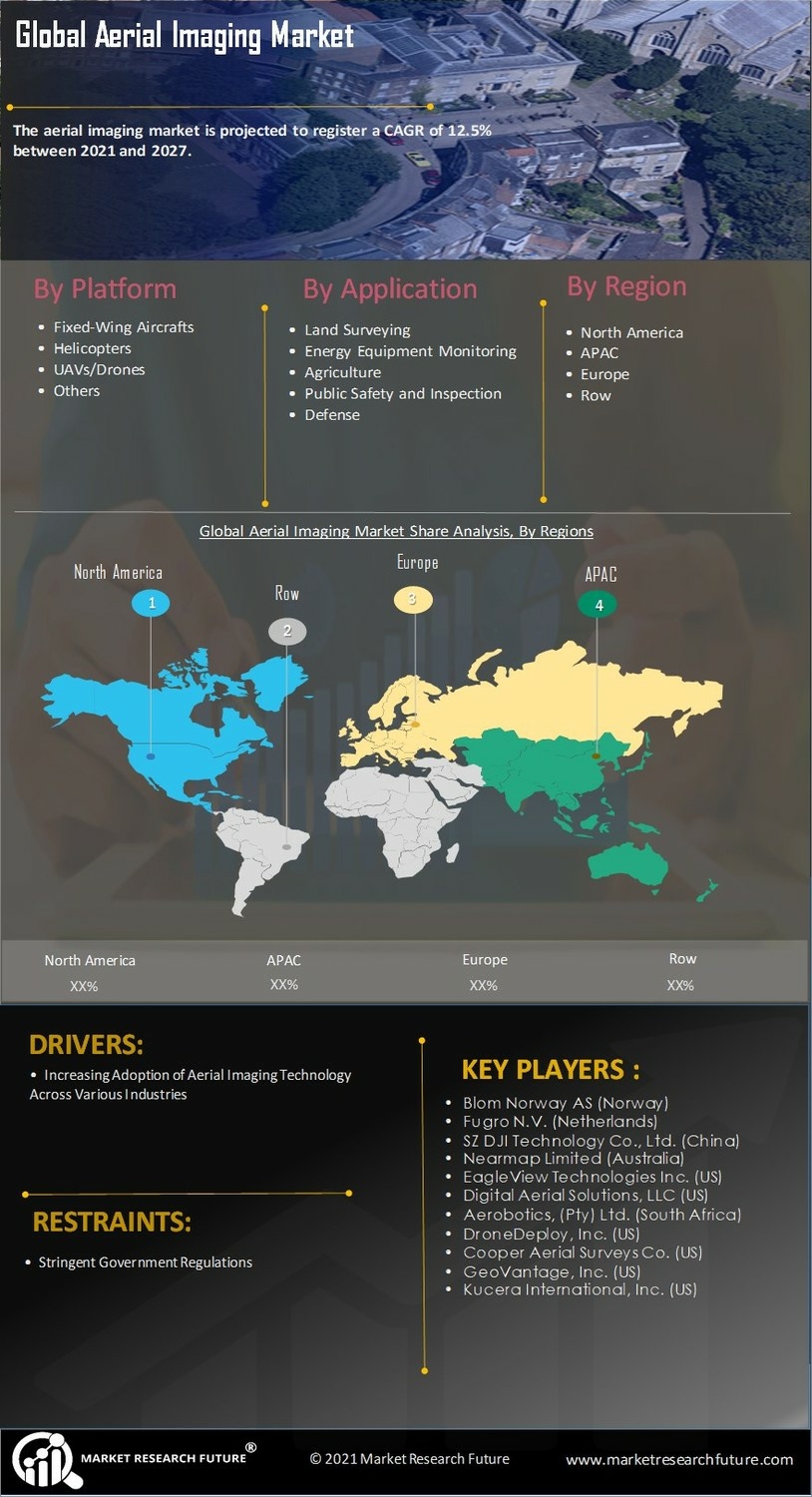
The global aerial imaging market growth is expected to be at a rate of 12.5% over the analysis period (between 2021 and 2027) on account of growing advancements in aerial imaging technology.


Recent News :


In October 2023, Verge Aero, the top provider of drone show technology, introduced its latest drone, the Verge Aero™ X7™. This new drone incorporates advanced technology into Verge Aero's comprehensive drone show product suite, making it more accessible for anybody to enter the aerial entertainment sector. The Verge Aero X7 offers comprehensive software for designing and managing drone shows, along with highly competitive pricing. Its goal is to reduce obstacles for individuals and organizations interested in drone entertainment, simplifying the process of producing drone shows of any scale and complexity for various events.


The Verge Aero X7 is currently open for orders, providing a range of options that include a basic package deal for new clients. The Verge Aero X7 is specifically built for efficient storage and transportation, and incorporates cutting-edge technology to provide exceptional durability and sustained performance. The X7 features an advanced battery technology that enables fast charging and extends the battery life.


Additionally, it delivers improved GPS accuracy, enhanced resistance to wind and rain, and user-friendly upgrades to the integrated control software.The Patria 6×6 wheeled armored personnel vehicles were introduced in Latvia. EMJ Metāls SIA, a Latvian company, is currently engaged in the manufacturing process under the production rights granted by the Finnish corporation Patria. The company received certification for autonomously producing APC hulls without the need for professionals from Finland, thereby validating the successful transfer of the corresponding technologies.


Market Segment Overview


  • Increasing Demand for UAV/Drone-based Aerial Imaging to Bolster Demand for UAVs/Drones


The global aerial imaging market based on platform type has been segmented into fixed-wing aircraft, helicopters, UAVs/drones, and others. The UAVs/drones segment is expected to dominate the market over the forecast duration. This is due to an increase in their adoption for applications such as precision agriculture, surveying & mapping, insurance claim verification, aerial remote sensing, to name a few. Increasing spending by the defense agencies around the world on the procurement of military-grade UAVs/ drones is also expected to boost the demand for UAVs/drones during the forecast period.


Growing Use of Aerial Imaging Solutions for Defense and Homeland Securityto Observe Strong Demand in the Defense Segment


Based on application, the aerial imaging market has been classified into land surveying, energy equipment monitoring, agriculture, public safety and inspection, and defense. In 2020, the defense segment held the largest market share. The increasing use of drones in defense and homeland security to identify challenges related to terrorism and precisely locate vulnerable areas are expected to contribute to the demand for aerial imaging solutions in the segment. Drones help the military augment their force, thereby enhancing their capabilities to subdue terror and counter the emerging challenges related to terrorism and national security. Thus, the defense segment is likely to be responsible for a major chunk of aerial imaging market revenues in the coming years during the review timeline.


Regional Analysis


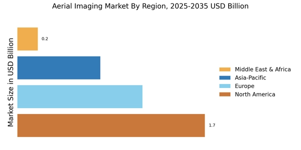
  • North America Accounted for the Largest Market Share


North America dominates the aerial imaging market. The dominance of the region in the aerial imaging market is projected to continue throughout the forecast period,owing to the presence of prominent players such as EagleView Technologies Inc., Nearmap Limited, Digital Aerial Solutions, LLC, and SZ DJI Technology Co., Ltd. Additionally, the region is home to some of the major players operating in the aerial imaging market, including EagleView Technologies Inc., DroneDeploy, Inc., Cooper Aerial Surveys Co., and Digital Aerial Solutions, LLC.Additionally, the growing adoption of aerial imaging solutions by organizations both at the public and private levels is expected to boost the growth of the North America aerial imaging market during the study period.


APAC Projected to Register a Significant Growth owing to the Rapidly Increasing Adoption of Aerial Imaging Solutions across Several Industry Verticals


The aerial imaging market in APAC is projected to exhibit a significant CAGR during the forecast period. The increasing adoption of aerial imaging solutions, primarily across the energy, agriculture, and land surveying sectors in countries such as India and China,is expected to drive market growth. Asia-Pacific provides a lucrative opportunity for the companies offering aerial imaging solutions to invest in. In addition, the major energy companies in the region have bolstered their optimization plans with innovative digital solutions, which is projected to bode well for the growth of aerial imaging solutions in the region.


Rise in Geographic Data Acquisition and Aerial Inspections Bode Well for the Aerial Imaging Market Growth in Europe


Europe held a significant share in the aerial imaging market in 2020. The increasing demand for geographic data using UAVs, aerial surveys, and aerial imagery drives the growth of the aerial imaging market in European countries such as the Netherlands andthe UK. Furthermore, the countries in the region have increased their spending significantly on the acquisition of geographic data and aerial surveys, primarily for oil and gas exploration, coastal navigation, and disaster management, which, in turn, is anticipated to fuel the regional market growth.


Competitive Landscape


  • Significant Investments by Players to Boost Competition


The global aerial imaging market is anticipated to grow significantly in the coming years due to the increasing adoption of aerial imaging technology across various industries and growing location-based services (LBS) and real-time location systems (RTLS). The global aerial imagingmarket is characterized by the presence of several global and regional vendors. The market is highly competitive, with all the players trying to gain maximum market share. Frequent changes in government policies, intense rivalry, and government regulations are the key factors that impact the global market growth. The vendors compete based on cost, product quality, and reliability.


List of Key Companies Covered in this Report


  • Blom Norway AS (Norway)

  • Fugro N.V. (Netherlands)

  • SZ DJI Technology Co., Ltd. (China)

  • Nearmap Limited (Australia)

  • EagleView Technologies Inc. (US)

  • Digital Aerial Solutions, LLC (US)

  • Aerobotics, (Pty) Ltd. (South Africa)

  • DroneDeploy, Inc. (US)

  • Cooper Aerial Surveys Co. (US)

  • GeoVantage, Inc. (US)

  • Kucera International, Inc. (US)


Recent Developments


  • February 2022: Arrowhawk Imaging's initial airborne imaging system launched an UltraCam Eagle Mark 3 aerial camera system equipped with a 100mm lens. The mapping company successfully completed multiple projects since obtaining the sensor from Vexcel Imaging in 2019 and deploying it in a Cessna 206 single-engine plane. Vexcel's technology provided with a competitive edge because the Eagle Mark 3 has a huge footprint and a high frame rate, which enabled more efficient flight without losing quality or accuracy.


  • 2022 February: Vexcel Data Program announced the availability of a new SDK (software development kit) that enables developers to integrate the world's largest aerial imaging program into their own apps. With MapControl SDK, developers can create more immersive experiences for showcasing high-resolution photography and geospatial data. MapControl SDK enables developers to construct and integrate MapControl functionality into their own online and desktop applications, as well as into GIS, CAMA, and CAD systems. MapControl SDK enables developers to leverage Vexcel's aerial imagery capabilities by leveraging the same time-tested code that powers Vexcel's own web-based application.


Report Overview


Scope of the Report


The scope of the report highlights drivers, opportunities, restraints, and challenges surrounding the global market. With easy-to-comprehend segmentation that includes operation, platform,and region, MRFR projections are on the basis of historical as well as expected trends. Major firms active in the global market have been profiled and paired with the top strategies employed by them to remain competitive in the industry.


Segmentation Table


Platform Type


  • Fixed-Wing Aircrafts

  • Helicopters

  • UAVs/Drones

  • Others


Application


  • Land Surveying

  • Energy Equipment Monitoring

  • Agriculture

  • Public Safety and Inspection

  • Defense

Report Attribute/Metric Details
  Market Size   USD 8.52 Billion
  CAGR   14.2% (2020–2030)
  Base Year   2020
  Forecast Period   2020-2030
  Historical Data   2019
  Forecast Units   Value (USD Million)
  Report Coverage   Revenue Forecast, Competitive Landscape, Growth Factors, and Trends
  Segments Covered   Platform Type and Application
  Geographies Covered   North America, Europe, Asia-Pacific, Middle East & Africa, and Latin America
  Key Vendors   Blom Norway AS, Fugro N.V., SZ DJI Technology Co., Ltd., Nearmap Limited, EagleView Technologies Inc., Digital Aerial Solutions, LLC, Aerobotics, (Pty) Ltd., DroneDeploy, Inc., Cooper Aerial Surveys Co., Geovantage, Inc., and Kucera International, Inc.
  Key Market Opportunities   Growing Adoption of Aerial Imaging Solutions in the Agriculture Sector
  Key Market Drivers   IncreasingAdoption of Aerial Imaging Technology Across Various Industries Growing Location-Based Services (LBS) and Real-Time Location Systems (RTLS)


Frequently Asked Questions (FAQ) :

Aerial Imaging Market registering a CAGR of 14.2% during 2020-2030.

Blom Norway AS (Norway),Fugro N.V. (Netherlands),SZ DJI Technology Co., Ltd. (China),Nearmap Limited (Australia),EagleView Technologies Inc. (US),Digital Aerial Solutions, LLC (US),Aerobotics, (Pty) Ltd. (South Africa),DroneDeploy, Inc. (US),Cooper Aerial Surveys Co. (US),GeoVantage, Inc. (US),Kucera International, Inc. (US)

North America Accounted for the Largest Market Share

Increasing Adoption of Aerial Imaging Technology Across Various Industries

Leading companies partner with us for data-driven Insights.

client_1 client_2 client_3 client_4 client_5 client_6 client_7 client_8 client_9 client_10

Kindly complete the form below to receive a free sample of this Report

Please fill in Business Email for Quick Response

We do not share your information with anyone. However, we may send you emails based on your report interest from time to time. You may contact us at any time to opt-out.

Purchase Option
Single User $ 4,950
Multiuser License $ 5,950
Enterprise User $ 7,250
Compare Licenses
Tailored for You
  • Dedicated Research on any specifics segment or region.
  • Focused Research on specific players in the market.
  • Custom Report based only on your requirements.
  • Flexibility to add or subtract any chapter in the study.
  • Historic data from 2014 and forecasts outlook till 2040.
  • Flexibility of providing data/insights in formats (PDF, PPT, Excel).
  • Provide cross segmentation in applicable scenario/markets.