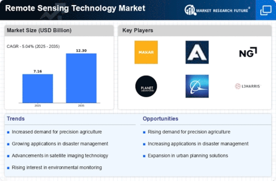
Top Industry Leaders in the Remote Sensing Technology Market
Competitive Landscape of the Remote Sensing Technology Market
The global remote sensing technology market is flourishing, fueled by an ever-growing demand for Earth observation data in diverse fields like agriculture, environmental monitoring, disaster management, and urban planning. This dynamic landscape boasts a diverse range of players, each vying for a piece of the pie through distinct strategies and strengths. Analyzing their approaches uncovers valuable insights into the ever-evolving competitive landscape.
Key Players:
- Northrop Grumman Corporation
- General Dynamics Corp
- Honeywell Technology Solutions Inc.
- Lockheed Martin Corporation
- ITT Corp.
- Lumasense Technologies, Inc.
- Thales Group
- Leica Geosystems Holdings AG
- DigitalGlobe
- Esri
- Hexagon AB
- Orbital Insight
- Planet Labs Inc.
- Raytheon Technologies Corporation
- Teledyne Technologies
- UrtheCast
- NASA
- Chia Tai
Strategies for Success:
- Technological Differentiation: Leading players are constantly pushing the boundaries of technology. High-resolution cameras, improved sensors, and advancements in AI-powered data analysis are key areas of focus.
- Data Democratization: Making data accessible and affordable for a wider range of users is crucial. This involves developing user-friendly platforms, offering data subscriptions, and exploring open-source initiatives.
- Strategic Partnerships: Collaborations between players with complementary strengths are becoming increasingly common. This allows for wider market reach, improved data collection and analysis capabilities, and access to niche expertise.
- Vertical Focus: Targeting specific industry needs with customized solutions is proving effective. Players are developing specialized applications for agriculture, forestry, mining, and urban planning, driving market penetration.
Factors for Market Share Analysis:
- Satellite Capabilities: Resolution, revisit frequency, data bandwidth, and onboard processing capabilities all play a role in determining a satellite's value proposition.
- Data Management: The ability to efficiently store, process, and analyze massive datasets is critical for attracting and retaining customers.
- Application Development: Providing user-friendly tools and creating industry-specific applications adds value to the data and expands market reach.
- Global Presence: Access to ground stations and data distribution networks across the globe is essential for catering to diverse user needs.
- Government Support: Securement of government contracts for national security and environmental monitoring projects can significantly boost market share.
New and Emerging Companies:
- Emerging Geospatial Startups: Startups like Orbital Insight and Descartes Labs are leveraging AI and machine learning to extract valuable insights from remote sensing data, creating new markets for predictive analytics and automated decision-making.
- Drone Technology Companies: Companies like DJI and Parrot are making high-quality drones more accessible and affordable, opening up new opportunities for smaller-scale, localized data collection.
- CubeSat Developers: With their rapid deployment capabilities and lower costs, cubeSats are gaining traction for research and educational applications, potentially democratizing access to space-based data.
Current Company Investment Trends:
- Consolidation: Mergers and acquisitions are on the rise as established players aim to expand their capabilities and acquire new technologies.
- Focus on AI and Analytics: Investments in AI-powered data analysis platforms and machine learning algorithms are increasing to unlock the full potential of remote sensing data.
- Cybersecurity: Protecting sensitive data from cyberattacks is a growing concern, leading to investments in data security infrastructure and encryption technologies.
- Sustainability: Utilizing remote sensing for environmental monitoring and resource management is attracting funding from sustainability-focused investors.
- Open Source Initiatives: Some companies are investing in open-source data and software platforms to foster collaboration and accelerate innovation within the industry.
Latest Company Updates:
Planet Labs Launches New Hyperspectral Constellation: Planet Labs announced on January 18th the launch of 44 SuperDove satellites equipped with hyperspectral sensors. This constellation will provide detailed spectral data for applications in agriculture, environmental monitoring, and mineral exploration.
Airbus Partners with Maxar for Earth Observation Data Services: Airbus and Maxar Technologies announced a strategic partnership on January 16th to offer joint Earth observation data services. This collaboration will combine Airbus's satellite infrastructure with Maxar's data analysis expertise, providing customers with a comprehensive solution.
Indian Space Research Organisation Launches EOS-02 Satellite: The Indian Space Research Organisation (ISRO) successfully launched the EOS-02 satellite on January 12th. This satellite will provide high-resolution optical and infrared data for various applications, including agriculture, disaster management, and urban planning.
Google Earth Engine Launches New Feature for Flood Monitoring: Google Earth Engine announced on January 8th the launch of a new flood monitoring tool. This tool uses satellite data and machine learning to detect and track floods in near real-time, providing valuable information for disaster preparedness and response.


