Geospatial Analytics Market

Key Players: Esri, Hexagon AB, Trimble Inc., Google (Alphabet), Microsoft, Oracle, IBM, SAP

Geospatial Analytics Market

Geospatial Analytics Market Size, Share and Research Report By Component (Software, Services, Hardware), By Analysis Type (Surface Analysis, Network Analysis, Other Analysis Types), By Deployment Model (Cloud, On-Premises), By End-User Vertical (Government, Defense & Intelligence, Natural Resources, Utility & Communication, Transportation & Logistics, Other Verticals) and By Regional (North America, Europe, South America, Asia Pacific, Middle East and Africa) - Industry Forecast to 2035.
ID: MRFR/ICT/4345-CR
100 Pages
Ankit Gupta
Last Updated: June 17, 2026

Geospatial Analytics Market Summary

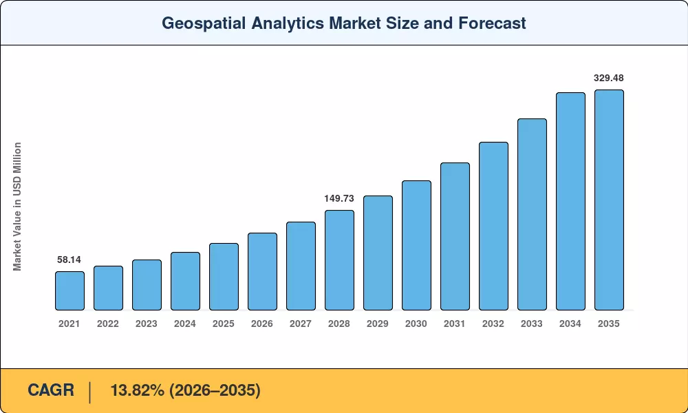
The Geospatial Analytics Market reached an estimated USD 100.26 Billion in 2025 and is projected to climb from USD 115.58 Billion in 2026 to USD 329.48 Billion by 2035, expanding at a 13.82% CAGR over the forecast period. Two forces are propelling this trajectory: governments treating geographic information systems as sovereign infrastructure — exemplified by India's National Geospatial Policy mandating open spatial data — and enterprises racing to embed location intelligence software into real-time decision-making. The U.S. Geospatial Data Act and China's BeiDou satellite constellation underscore how national-level commitments are channeling billions into spatial data visualization capabilities[2].

Legacy on-premises GIS stacks, once the default for mapping analytics tools, are giving way to cloud-native platforms capable of processing petabyte-scale satellite imagery in minutes rather than days. Daily revisit of smallsat constellations has compressed insight latency, and 5G rollouts now allow edge devices to stream high-fidelity spatial feeds. Enterprise spending on GIS data analysis platforms surpassed USD 40 Billion in 2024 alone, driven by logistics optimization, precision agriculture, and autonomous vehicle routing programs [3][4].

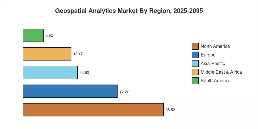
North America commands a leading 38.42% share of the Geospatial Analytics Market, anchored by federal programs and a deep bench of analytics vendors. Asia-Pacific is the fastest-growing region at a projected 14.89% CAGR, fueled by smart-city initiatives across China, India, and ASEAN nations. Europe holds the second-largest share at approximately 26%, with Copernicus open-data mandates and the EU's Artificial Intelligence Act shaping compliance-driven demand. As spatial data becomes a connective layer for autonomous systems, ESG reporting, and climate adaptation, the Geospatial Analytics Market is positioned for sustained double-digit expansion through 2035 [5][6].


Key Report Takeaways

• By Component

  • Software held the dominant position in the Geospatial Analytics Market in 2025, capturing approximately 44.21% of total revenue — reflecting enterprise preference for integrated geographic information systems platforms
  • Services are projected to register a 14.53% CAGR through 2035, as organizations outsource GIS data analysis implementation and managed analytics operations
  • Hardware contributed USD 19.85 Billion in 2025, driven by sensor arrays, GNSS receivers, and LiDAR equipment deployments

• By Analysis Type

  • Surface analysis represented the largest analysis-type segment in the Geospatial Analytics Market, accounting for 38.32% of 2025 revenue


• By Deployment

  • Surface analysis represented the largest analysis-type segment in the Geospatial Analytics Market, accounting for 38.32% of 2025 revenue
  • Cloud deployment is growing at a 14.24% CAGR, outpacing on-premises alternatives as enterprises migrate spatial data visualization workloads to elastic platforms

• By Region

  • North America retained a 38.42% share of the Geospatial Analytics Market in 2025, supported by federal geospatial modernization spending
  • Asia-Pacific is forecast to record the highest regional CAGR of 14.89%, with location intelligence software adoption accelerating in China and India


Market Size and Forecast (2021–2035)

MRFR's estimates blend primary interviews with 180+ enterprise buyers, vendor financials, and satellite/sensor deployment databases. Historical figures (2021–2024) reflect audited revenue and verified procurement data; forecast figures (2026–2035) apply a calibrated compound growth model validated against macroeconomic indicators and technology adoption curves.

Geospatial Analytics Market Size and Forecast
Our Impact
Enabled $4.3B Revenue Impact for Fortune 500 and Leading Multinationals
Partnering with 2000+ Global Organizations Each Year
30K+ Citations by Top-Tier Firms in the Industry
 

Driver Impact Analysis

Driver ~% Impact on CAGR Geographic Relevance Impact Timeline
Cloud-native geospatial platforms ~22% Global Short-term (≤2 yr)
5G and edge computing rollouts ~18% North America, Asia-Pacific Medium-term (2–4 yr)
Smallsat constellation expansion ~16% Global Short-term (≤2 yr)
Autonomous vehicle mapping demand ~14% North America, Europe Medium-term (2–4 yr)
National geospatial open-data mandates ~12% Asia-Pacific, Europe Long-term (≥4 yr)
ESG and climate risk spatial reporting ~10% Europe, North America Long-term (≥4 yr)
Precision agriculture and rural analytics ~8% South America, Asia-Pacific Medium-term (2–4 yr)


Smallsat Constellation Expansion

Earth-observation revisit rates are now driven to daily or sub-daily cadences by the trinity of Planet Labs, Spire Global, and Maxar’s WorldView Legion, with gigabytes of raw imagery being generated per orbit. The decreasing launch price of SpaceX (less than USD 2,700 per kilogram to low Earth orbit in 2025 [8]) has allowed start-ups to install constellations for less than USD 100 Million [8]. This data deluge is a key feed for spatial data visualization platforms and stimulates the demand for mapping analytics solutions that can perform automatic feature extraction.


ESG and Climate Risk Reporting

From 2025, the EU’s Corporate Sustainability Reporting Directive (CSRD) will force more than 50,000 enterprises to start reporting on climate-related, location-based hazards. Now insurers and asset managers use overlays of geographic information systems to predict flood, wildfire, and heat-island vulnerability across portfolios [10]. This regulatory drive is turning GIS data analysis into a compliance imperative rather than a discretionary expenditure.


Restraints Impact Analysis

The restraint percentages below represent estimated drag on the CAGR and are directional indicators, not precise deductions from headline growth.

Restraint ~% Drag on CAGR Geographic Relevance Impact Timeline
Data interoperability gaps ~−3.5% Global Long-term (≥4 yr)
Privacy and cross-border data regulation ~−2.8% Europe, Asia-Pacific Medium-term (2–4 yr)
High integration complexity for legacy systems ~−2.2% North America, Europe Short-term (≤2 yr)
Skilled talent shortage in spatial analytics ~−1.8% Global Medium-term (2–4 yr)
Cybersecurity risks for sensitive geospatial data ~−1.5% Global Long-term (≥4 yr)


Data Interoperability Gaps

The OGC has been trying to fix this, but the proprietary data formats are deeply embedded in vendor ecosystems. Data wrangling and format conversion consume 30–40% of the geospatial project costs of enterprises [12]. Until universal standards are adopted, the friction cost of integrating diverse mapping analytics solutions will limit the pace of enterprise-wide GIS deployment.


Talent Shortage in Spatial Analytics

A 2024 Geospatial World survey found that 62% of enterprises cited a lack of skilled spatial data scientists as their primary adoption barrier [15]. University programs produce roughly 8,000 geospatial specialists annually worldwide, against an estimated industry demand exceeding 35,000. This gap constrains the speed at which organizations can operationalize spatial data visualization investments.


Geospatial Analytics Market Opportunities

AI-Driven Automated Feature Extraction

Foundation models trained on satellite imagery – like Meta’s Segment Anything Model tailored for Earth observation – can detect buildings, roads, and vegetation within seconds rather than hours. This cuts down the manual labor aspect of GIS data processing by as much as 90% and opens the Geospatial Analytics Market to mid-market consumers who previously lacked the expert staff


Autonomous Mobility and Drone Logistics

And the development of high-definition maps is crucial for self-driving cars and delivery drones. The requirement for ongoing revenue for spatial data visualization vendors from HD mapping refresh cycles, which require centimeter-level accuracy. The U.S. FAA’s 2025 enhanced BVLOS drone permits will further increase the demand for real-time geographic information systems feeds


Geospatial Analytics Market Future Outlook


Platform Economics and Marketplace Models

Geospatial platforms are evolving from monolithic software suites into marketplace ecosystems where third-party developers publish analytics modules, trained models, and curated datasets. This mirrors the SaaS marketplace trajectory seen in CRM and ERP — and could expand the addressable market for location intelligence software by 30–40% as it lowers entry barriers for niche verticals such as insurance risk scoring and retail site selection [18].


Sovereign Geospatial Stacks

Data sovereignty concerns are pushing nations to build independent spatial infrastructure — satellite constellations, national mapping agencies with cloud-native mapping analytics tools, and domestically developed geographic information systems software. The EU's planned Iris² secure connectivity constellation and India's Bharatnet-linked geospatial layer illustrate this trend [19]. Sovereign stack investments will add incremental demand while fragmenting global interoperability.


Geospatial Analytics Market Segmentation

By Component

Segment Key Metric Primary Demand Driver
Software 44.21% share (2025) Enterprise GIS platforms and location intelligence software suites
Services 14.53% CAGR (2026–2035) Managed analytics, consulting, and system integration
Hardware USD 19.85 Billion (2025) LiDAR, GNSS receivers, sensor arrays


Software dominates the Geospatial Analytics Market because enterprises prioritize integrated geographic information systems platforms that unify data ingestion, spatial data visualization, and decision-support workflows. Vendors like Esri, Hexagon, and Trimble have expanded cloud-native offerings, enabling subscription-based pricing that lowers upfront barriers. The services segment is the fastest-growing component as organizations seek end-to-end GIS data analysis implementation — from data engineering to model deployment — without building internal teams from scratch.

Hardware remains essential for primary data capture. LiDAR unit costs have fallen 60% since 2020, democratizing 3D mapping analytics tools for construction, forestry, and autonomous vehicle applications. GNSS multi-frequency receivers now deliver centimeter-level accuracy at price points accessible to mid-market firms [8].

By Analysis Type

Segment Key Metric Primary Demand Driver
Surface Analysis 38.32% share (2025) Terrain modeling, land-use classification, flood mapping
Network Analysis 14.72% CAGR (2026–2035) Transportation routing, utility network optimization
Other Analysis Types USD 26.18 Billion (2025) Proximity analysis, geostatistics, spatial clustering


Surface analysis leads because elevation modeling and land-cover classification are foundational to nearly every geospatial workflow — from agricultural yield prediction to urban heat-island mapping. The Geospatial Analytics Market sees network analysis as its fastest-expanding frontier, driven by logistics companies optimizing last-mile delivery routes and utilities modernizing grid management through spatial data visualization of network topology [9].

By Deployment Model

Segment Key Metric Primary Demand Driver
Cloud 49.28% share (2025) Elastic processing for petabyte-scale imagery
On-Premises USD 50.92 Billion (2025) Defense and classified-environment requirements


Cloud deployment has crossed the majority threshold in the Geospatial Analytics Market as hyperscaler platforms offer purpose-built geographic information systems services. On-premises retains relevance in defense, intelligence, and regulated industries where data sovereignty requirements prohibit external hosting of sensitive location intelligence software workloads.

By End-User Vertical

Segment Key Metric Primary Demand Driver
Government 25.42% share (2025) Census, land administration, disaster response
Defense & Intelligence 13.94% CAGR (2026–2035) ISR, mission planning, terrain analysis
Natural Resources USD 12.84 Billion (2025) Mining, forestry, oil & gas exploration
Utility & Communication 14.18% CAGR (2026–2035) Grid modernization, 5G tower siting
Transportation & Logistics 15.58% CAGR (2026–2035) Route optimization, fleet tracking, HD mapping
Other Verticals USD 10.26 Billion (2025) Insurance, retail, real estate, healthcare


Government agencies remain the largest single buyer in the Geospatial Analytics Market, but transportation and logistics are rapidly closing the gap. Freight operators deploying real-time GIS data analysis for route optimization report 12–18% fuel cost reductions [9]. Defense and intelligence agencies continue investing in mapping analytics tools for situational awareness, while utilities accelerate spending on spatial data visualization to manage distributed energy assets.


Regional Market Share Analysis

Region Key Metric Primary Investment Themes
North America 38.42% share (2025) Federal GIS modernization, autonomous vehicles, defense
Europe USD 25.87 Billion (2025) Copernicus data, CSRD compliance, smart cities
Asia-Pacific 14.89% CAGR (2026–2035) BeiDou, smart cities, agricultural mapping analytics tools
South America USD 5.62 Billion (2025) Deforestation monitoring, precision agriculture
Middle East & Africa 13.14% CAGR (2026–2035) Smart city megaprojects, oil & gas asset management
Total USD 100.26 Billion (2025)

The Geospatial Analytics Market exhibits significant regional variation, reflecting differences in digital infrastructure maturity, regulatory posture, and spatial data visualization investment priorities.


North America

Country Key Metric Key Driver
US 78.4% of regional share NGA cloud migration, defense geospatial spending
Canada 13.28% CAGR Natural resource monitoring, pipeline mapping
Mexico USD 1.94 Billion (2025) Smart transportation and urban planning initiatives


The US dominates North America's Geospatial Analytics Market through massive federal procurement — the NGA, NOAA, and USDA collectively spend over USD 6 Billion annually on geographic information systems and satellite imagery contracts. Canada's oil-sands monitoring programs and Mexico's emerging smart-city corridors along the Bajío industrial belt add incremental demand for location intelligence software.

Europe

Country Key Metric Key Driver
Germany 22.6% of regional share Automotive HD mapping, Industry 4.0
UK 14.12% CAGR Ordnance Survey modernization, fintech location analytics
France USD 3.48 Billion (2025) Copernicus hub, defense spatial intelligence
Italy 12.74% CAGR Agricultural spatial analytics, cultural heritage mapping
Spain USD 1.87 Billion (2025) Renewable energy siting, tourism mapping analytics tools
Nordic Countries 13.56% CAGR Maritime routing, arctic monitoring
Russia USD 1.42 Billion (2025) GLONASS integration, resource extraction mapping
Rest of Europe 11.82% CAGR Varied infrastructure and compliance drivers


Europe's Geospatial Analytics Market benefits from the Copernicus programme's free data distribution, which has stimulated a downstream analytics ecosystem worth over USD 8 Billion. The CSRD's spatial disclosure requirements and the AI Act's geospatial provisions are compelling enterprises to invest in compliant GIS data analysis solutions [13].

Asia-Pacific

Country Key Metric Key Driver
China 34.8% of regional share BeiDou, smart-city pilots, defense modernization
India 15.62% CAGR Open geospatial policy, agricultural mapping
Japan USD 3.92 Billion (2025) Disaster preparedness, autonomous logistics
South Korea 14.28% CAGR 5G-enabled spatial services, digital twin cities
ASEAN USD 2.74 Billion (2025) Infrastructure development, flood monitoring
Rest of Asia-Pacific 13.41% CAGR Emerging digital infrastructure programs


Asia-Pacific represents the fastest-growing frontier for the Geospatial Analytics Market. China's BeiDou Navigation Satellite System, achieving global coverage in 2020, underpins a domestic spatial data visualization industry projected to outpace Western markets. India's open-data mandate has attracted over 400 startups to the geographic information systems ecosystem since 2023 [2][5].

South America

Country Key Metric Key Driver
Brazil 58.3% of regional share Amazon deforestation monitoring, agribusiness
Argentina 12.96% CAGR Precision farming, lithium mining mapping
Rest of South America USD 1.18 Billion (2025) Infrastructure and resource management


Brazil's INPE satellite monitoring program, tracking Amazon deforestation in near-real time, is the continent's flagship application of location intelligence software. Argentina's lithium triangle development is driving demand for subsurface mapping analytics tools [11].

Middle East & Africa

Country Key Metric Key Driver
Saudi Arabia 32.7% of regional share NEOM, Vision 2030 smart-city investments
UAE 14.52% CAGR Dubai digital twin, logistics hub optimization
South Africa USD 0.68 Billion (2025) Mining and agricultural spatial analytics
Egypt 13.08% CAGR New Administrative Capital development
Rest of MEA USD 1.14 Billion (2025) Oil & gas, humanitarian mapping


Saudi Arabia's NEOM project alone is expected to drive over USD 1.2 Billion in geospatial procurement through 2030, making it a singular catalyst for the Geospatial Analytics Market in this region. The UAE's mandatory BIM and GIS integration policy for public works further accelerates the adoption of spatial data visualization tools [6].


Geospatial Analytics Market By Region, 2025-2035
 

Competitive Benchmarking

The Geospatial Analytics Market exhibits medium concentration, with the top five players collectively holding an estimated 35–42% revenue share. The Herfindahl-Hirschman Index (HHI) sits in the 800–1,200 range, indicating a moderately fragmented competitive structure. Innovation cycles are rapid, and cloud-native entrants are challenging incumbent geographic information systems vendors through AI-differentiated location intelligence software offerings.

Company Est. Revenue Share Range Key Offerings for Geospatial Analytics Market Strategic Positioning
Esri ~10–14% ArcGIS platform, ArcGIS Online, spatial analytics APIs Dominant GIS platform provider with deepest government relationships
Hexagon AB ~6–9% HxGN Content Program, Luciad portfolio, sensor platforms Integrated hardware-software stack for defense and industrial mapping
Trimble Inc. ~5–8% Trimble Unity, eCognition, positioning solutions Precision positioning and construction-focused spatial data visualization
Google (Alphabet) ~4–7% Google Earth Engine, Maps Platform, BigQuery GIS Hyperscaler with unmatched satellite imagery archive and AI capabilities
Microsoft ~3–6% Azure Maps, Planetary Computer, AI for Earth Cloud-native GIS data analysis integrated with enterprise Azure ecosystem
Oracle ~3–5% Oracle Spatial and Graph, Autonomous Database Spatial Enterprise database with embedded geographic information systems functions
IBM ~2–4% Environmental Intelligence Suite, PAIRS Geoscope Climate and weather analytics with location intelligence software layers
SAP ~2–4% SAP HANA Spatial Engine, Business Technology Platform ERP-integrated spatial analytics for supply chain and logistics
Pitney Bowes ~2–3% MapInfo, Spectrum Spatial, location data services Mid-market mapping analytics tools with strong data enrichment portfolio
Bentley Systems ~2–3% iTwin Platform, OpenCities, contextual digital twins Infrastructure digital twins with embedded spatial data visualization


Recent News & Developments


  • Hexagon AB (January 2025): Scaled its core global localization portfolio by acquiring the specialized GNSS positioning receiver developer Septentrio NV.


  • Indian Ministry of Science (June 2024): Supervised ongoing data deregulation projects through the Department of Science and Technology to support national mapping platforms.
  • European Space Agency (April 2024): Approved the Copernicus Sentinel Expansion program, adding six new satellite missions through 2030 to feed spatial data visualization platforms with higher-resolution data [24].


  • Planet Labs (December 2023): Achieved daily global revisit capability with its SuperDove constellation, delivering sub-3-meter resolution imagery to the Geospatial Analytics Market [8].


Geospatial Analytics Market Report Scope

Parameter Detail
Market Scope Global Geospatial Analytics Market covering software, services, hardware, all analysis types, deployment models, and end-user verticals
Study Period 2021–2035
CAGR 13.82% (2026–2035)
Base Year Market Size USD 100.26 Billion (2025)
Forecast Endpoint USD 329.48 Billion (2035)
Fastest Growing Segment Transportation & Logistics (by end user); Services (by component)
Companies Profiled 10 (Esri, Hexagon, Trimble, Google, Microsoft, Oracle, IBM, SAP, Pitney Bowes, Bentley Systems)
Valuation Currency USD Billion
Methodology Combination of bottom-up revenue modeling, primary interviews (180+ stakeholders), secondary research, and proprietary MRFR estimation frameworks


FAQs

How do enterprises typically evaluate ROI when procuring geospatial analytics platforms?

Buyers benchmark ROI against three metrics: reduction in manual data processing hours, improvement in decision-cycle speed, and measurable operational savings such as fuel or routing costs. Most enterprises target payback within 18–24 months of deployment [9].

What differentiates cloud-native GIS platforms from legacy on-premises solutions in procurement decisions?

Cloud-native platforms eliminate upfront capital expenditure, scale elastically with data volume, and receive continuous feature updates. On-premises solutions remain preferable only when classified data handling or air-gapped networks are mandatory [3].


What role does edge computing play in real-time geospatial analytics for autonomous vehicles?

Edge nodes process LiDAR and camera feeds locally, reducing round-trip latency to under 10 milliseconds. This is critical for HD map updates, where cloud-only architectures introduce unacceptable delays for safety-critical navigation [9].

How does the Geospatial Analytics Market address data bias in AI-driven spatial models?

Training datasets often over-represent urban areas in developed nations, creating accuracy gaps in rural and developing regions. Leading vendors mitigate this through synthetic data augmentation and federated learning across diverse geographic training sets [15].


How is the Geospatial Analytics Market responding to increasing demand for indoor spatial analytics?

Indoor positioning systems using ultra-wideband and Bluetooth beacons are extending location intelligence beyond outdoor GPS coverage. Retail, healthcare, and logistics facilities are adopting indoor mapping analytics tools to optimize space utilization and foot-traffic flows [18].


Author
Author
Author Profile
Ankit Gupta LinkedIn
Team Lead - Research
Ankit Gupta is a seasoned market intelligence and strategic research professional with over six plus years of experience in the ICT and Semiconductor industries. With academic roots in Telecom, Marketing, and Electronics, he blends technical insight with business strategy. Ankit has led 200+ projects, including work for Fortune 500 clients like Microsoft and Rio Tinto, covering market sizing, tech forecasting, and go-to-market strategies. Known for bridging engineering and enterprise decision-making, his insights support growth, innovation, and investment planning across diverse technology markets.

Research Approach


Secondary Research

The secondary research process involved comprehensive analysis of geospatial data repositories, satellite imagery archives, peer-reviewed remote sensing journals, and authoritative spatial data infrastructure publications. Key sources included the United States Geological Survey (USGS), National Geospatial-Intelligence Agency (NGA), U.S. Census Bureau TIGER/Line Database, National Oceanic and Atmospheric Administration (NOAA), NASA Earth Science Data Systems (EOSDIS), European Space Agency (ESA) Copernicus Programme, EU INSPIRE Geoportal, Open Geospatial Consortium (OGC) Standards Repository, International Organization for Standardization (ISO/TC 211), Group on Earth Observations (GEO) Portal, United Nations Global Geospatial Information Management (UN-GGIM), U.S. Federal Geographic Data Committee (FGDC), American Society for Photogrammetry and Remote Sensing (ASPRS), Urban and Regional Information Systems Association (URISA), Geospatial Information & Technology Association (GITA), and national mapping agencies (Ordnance Survey UK, Bundesamt für Kartographie Germany, National Administration of Surveying China).

These sources were employed to gather satellite deployment statistics, spatial data infrastructure regulations, geospatial technology adoption metrics, smart city initiative datasets, and remote sensing application trends in the environmental monitoring, urban planning, defense, and agriculture verticals.


Primary Research

Qualitative and quantitative insights were obtained by interviewing supply-side and demand-side stakeholders during the primary research process. CEOs, CTOs, VPs of Geospatial Solutions, and chiefs of Earth Observation divisions from GIS software vendors, satellite operators, and remote sensing data providers comprised supply-side sources. Furthermore, spatial data infrastructure policymakers, executives from national mapping organizations, and program directors from defense and intelligence agencies were consulted. Demand-side sources included urban planning directors, agriculture technology managers, construction project managers who integrated BIM-GIS, geospatial data scientists from natural resource enterprises, and Chief Information Officers from utility and transportation companies. The primary research validated market segmentation in the context of surface analytics and geovisualization technologies, confirmed the deployment timelines of satellite constellations, and collected insights on the dynamics of open-source geospatial platforms, location-based service pricing models, and cloud-based GIS adoption.

By Designation: C-level Primaries (28%), Director Level (35%), Others (37%)

By Region: North America (38%), Europe (32%), Asia-Pacific (24%), Rest of World (6%)


Market Size Estimation

Revenue mapping and geospatial data consumption volume analysis were employed to determine global market valuation. The methodology comprised the following:

The identification of over 50 essential providers in the regions of North America, Europe, Asia-Pacific, and Latin America, including GIS software, remote sensing services, GPS navigation, and spatial analytics platforms.

Technology mapping in the following segments: Remote Sensing, LiDAR, photogrammetry, 3D laser scanning, Global Positioning Systems (GPS), and Geographic Information Systems (GIS)

Examination of annual revenues that are specific to geospatial software licenses, satellite imagery sales, geospatial consulting services, and location intelligence platforms, as reported and modeled

In 2024, the coverage of providers will encompass 75-80% of the global market share. This includes key satellite operators (Maxar, Planet Labs), GIS software leaders (ESRI, Hexagon, Bentley), and integrated positioning companies (Trimble, Fugro).

Derive segment-specific valuations for surface analytics, network analytics, and geovisualization technologies through extrapolation using bottom-up (number of geospatial seats/licenses × ASP by region, plus satellite imagery square kilometers sold × unit pricing) and top-down (vendor revenue validation against enterprise IT spending analytics) approaches.

Validation against government spending data on spatial data infrastructure, defense geospatial intelligence budgets, and smart city geospatial technology investments from significant markets, including the United States, China, Germany, the United Kingdom, Japan, and India

Download Free Sample

Kindly complete the form below to receive a free sample of this Report

Download PDF ×

We do not share your information with anyone. However, we may send you emails based on your report interest from time to time. You may contact us at any time to opt-out.