info@marketresearchfuture.com   📞  +1 (855) 661-4441(US)   📞  +44 1720 412 167(UK)
Certified Global Research Member
Isomar fd.webp Wcrc 57.webp
Key Questions Answered
  • Global Market Outlook
  • In-depth analysis of global and regional trends
  • Analyze and identify the major players in the market, their market share, key developments, etc.
  • To understand the capability of the major players based on products offered, financials, and strategies.
  • Identify disrupting products, companies, and trends.
  • To identify opportunities in the market.
  • Analyze the key challenges in the market.
  • Analyze the regional penetration of players, products, and services in the market.
  • Comparison of major players financial performance.
  • Evaluate strategies adopted by major players.
  • Recommendations
Why Choose Market Research Future?
  • Vigorous research methodologies for specific market.
  • Knowledge partners across the globe
  • Large network of partner consultants.
  • Ever-increasing/ Escalating data base with quarterly monitoring of various markets
  • Trusted by fortune 500 companies/startups/ universities/organizations
  • Large database of 5000+ markets reports.
  • Effective and prompt pre- and post-sales support.

Terrestrial Laser Scanning Market Research Report: By Application (Construction, Civil Engineering, Heritage Preservation, Mining, Forestry), By Scanning Method (Ground-Based Laser Scanning, Airborne Laser Scanning, Mobile Laser Scanning, Terrestrial Laser Scanning), By End Use (Architecture, Land Surveying, Agriculture, Environmental Monitoring, Transportation), By Component (Hardware, Software, Services) and By Regional (North America, Europe, South America, Asia Pacific, Middle East and Africa) - Forecast to 2032.


ID: MRFR/A&D/31256-HCR | 100 Pages | Author: Sejal Akre| December 2024

Terrestrial Laser Scanning Market Overview


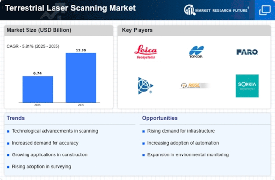
Terrestrial Laser Scanning Market Size was estimated at 5.69 (USD Billion) in 2022. The Terrestrial Laser Scanning Market is expected to grow from 6.02 (USD Billion) in 2023 to 10.0 (USD Billion) by 2032. The Terrestrial Laser Scanning Market CAGR (growth rate) is expected to be around 5.81% during the forecast period (2024 - 2032).


Key Terrestrial Laser Scanning Market Trends Highlighted


The Terrestrial Laser Scanning Market is experiencing significant growth due to several key market drivers. One of the primary factors is the increasing demand for accurate and efficient surveying and mapping solutions across various sectors, including construction, architecture, and environmental studies.


The precision and speed of terrestrial laser scanning contribute to improved project outcomes and reduce labor costs.


Additionally, the growing trend towards digital transformation in industries has led to the adoption of advanced technologies like 3D scanning, enhancing data collection and analysis processes. There are several opportunities to be explored within the market.


As industries continue to seek innovative and automated solutions, there is a rising demand for integration with Building Information Modeling (BIM) and Geographic Information Systems (GIS). This creates an avenue for companies to develop more sophisticated software and hardware that can accommodate these needs.


Furthermore, the expansion of urban infrastructure projects presents a significant opportunity for laser scanning technologies, as accurate data is crucial for the efficient planning and execution of such endeavors. Recent trends indicate a shift towards the use of portable and mobile scanning solutions driven by advancements in technology.


This allows for greater flexibility and ease of use, making it more accessible for various applications. The integration of artificial intelligence and machine learning is also becoming prevalent, offering improved data processing and analysis capabilities, which can enhance the overall efficiency of projects.


As digital technologies evolve, the terrestrial laser scanning market is likely to adapt, paving the way for new applications and innovations in multiple industries. These developments suggest that the market will continue to evolve and expand in response to changing technological landscapes and industry needs.


Terrestrial Laser Scanning Market Overview


Source: Primary Research, Secondary Research, MRFR Database and Analyst Review


Terrestrial Laser Scanning Market Drivers


Increased Demand for High-Precision Surveying


The Terrestrial Laser Scanning Market is experiencing a notable surge in demand for high-precision surveying solutions across various sectors, including construction, archaeology, and geospatial analysis.


This increases largely attributed to the growing need for accuracy in project execution minimizes errors and enhances efficiency in project delivery. Terrestrial laser scanning enables professionals to obtain detailed three-dimensional representations of structures, allowing for effective planning and management of construction projects.


As industries recognize the benefits associated with integrating advanced scanning technologies, investment in laser scanning equipment has seen a significant increase, promoting accuracy and reliability for various applications.


Furthermore, the advent of automated construction processes and Building Information Modeling (BIM) has underscored a crucial need for detailed topographical data, precipitating further adoption of terrestrial laser scanning solutions.


In numerous applications, such as civil engineering, the ability to generate point clouds facilitates improved analysis, allowing engineers to evaluate existing structures and make more educated decisions regarding design modifications effectively.


As such, the robustness offered by laser scanned data can lead to better project outcomes, heightened safety standards, and reductions in project costs which is vital for competitive performance in today's fast-paced market.


The overall enhancement in public and private investments toward infrastructure development continues to catalyze the growth of the Terrestrial Laser Scanning Market, bolstering its future prospects as stakeholders recognize laser scanning not just as an innovative tool but as an indispensable component of modern project management and execution.


Technological Advancements in Laser Scanning Equipment


Technological advancements in terrestrial laser scanning equipment are a primary driver propelling the Terrestrial Laser Scanning Market forward. Innovation in this field has led to the development of faster, more efficient scanning devices that can compile extensive data sets in a shorter timeframe.


Enhanced features such as improved data accuracy and resolution make modern laser scanners more appealing to various industries, including construction, mining, and environmental studies.


This growing sophistication allows for the seamless integration of terrestrial laser scanning with other technologies, such as drones and geographic information systems (GIS), enabling comprehensive data analysis for various applications.


As a result, companies are inclined to invest in state-of-the-art equipment to optimize their workflows and maintain competitiveness, further driving market growth.


Rising Investments in Infrastructure Development


The rise in investments in infrastructure development significantly contributes to the expansion of the Terrestrial Laser Scanning Market. Governments and private entities across the world are increasing their spending on infrastructure projects to meet the growing demand for transportation, utilities, and urban development.


The integration of terrestrial laser scanning technology in these projects provides accurate data essential for effective planning and execution.


Additionally, as urban areas continue to expand, maintaining existing infrastructure and ensuring safety requires precise monitoring, where laser scanning offers valuable insights. Consequently, this trend is expected to sustain a consistent demand for scanning services over the coming years, correlating with a boost in market value.


Terrestrial Laser Scanning Market Segment Insights


Terrestrial Laser Scanning Market Application Insights


Within the Application landscape, the Construction sector played a pivotal role, holding a substantial value of 2.1 USD Billion in 2023, anticipated to grow to 3.4 USD Billion by 2032, making it one of the dominant segments due to the increasing demand for precision and efficiency in construction projects.


Furthermore, Civil Engineering, valued at 1.5 USD Billion in 2023, is set to reach 2.5 USD Billion by 2032, driven by the need for advanced surveying techniques and project management practices that require accurate data collection.


Heritage Preservation held a notable position with a current valuation of 0.8 USD Billion in 2023 and is expected to grow to 1.3 USD Billion, reflecting a growing recognition of the importance of documenting and safeguarding historical sites through precise scanning technology.


The Mining sector, generating 0.9 USD Billion in 2023, is projected to expand to 1.6 USD Billion, highlighting its significance in resource management and geospatial mapping, which are critical for enhanced operational efficiency and safety.


Lastly, the Forestry application was valued at 1.72 USD Billion in 2023 but is anticipated to adjust to 1.2 USD Billion by 2032, indicating shifts in market dynamics and possibly reflecting cyclical demand patterns.


Each of these application areas presents distinct growth drivers and opportunities, fostering technological advances and deeper market penetration of Terrestrial Laser Scanning tools, with Construction and Civil Engineering standing out as the majority holding segments, largely due to the continuous need for infrastructure development.


As the Terrestrial Laser Scanning Market evolves, the data illustrates a strong correlation between advancing technology and the demands of these sectors, positioning them favorably for ongoing enhancement in operational methodologies.


Terrestrial Laser Scanning Market Type Insights


Source: Primary Research, Secondary Research, MRFR Database and Analyst Review


Terrestrial Laser Scanning Market Scanning Method Insights


The market is characterized by various scanning methods that play crucial roles across different applications. Ground-Based Laser Scanning is widely used for high-accuracy topographic surveys and is known for its effectiveness in complex environments. Airborne Laser Scanning has gained importance due to its ability to cover large areas efficiently, especially for forestry and environmental monitoring.


In contrast, Mobile Laser Scanning provides enhanced flexibility and real-time data collection, making it popular in urban planning and infrastructure assessment. Terrestrial Laser Scanning, as a whole, continues to dominate the market due to its versatility in applications such as construction, heritage preservation, and accident reconstruction.


Market trends show a rising adoption of these technologies for various applications, driven by the increasing demand for 3D mapping and modeling. Despite challenges like high equipment costs and the need for skilled operators, opportunities persist in the form of technological advancements and expanding industrial applications, further contributing to the overall growth of the Terrestrial Laser Scanning Market revenue and fostering diverse Terrestrial Laser Scanning Market segmentation.


Terrestrial Laser Scanning Market End Use Insights


The architecture sector showcases the increasing need for precise modeling and analysis, significantly driving market growth. Similarly, land surveying benefits from advanced scanning technologies that enhance accuracy and efficiency in data collection, dominating this sector with substantial application.


Agriculture is emerging as a noteworthy segment, leveraging laser scanning for precision farming and monitoring crop health. Environmental monitoring remains pivotal, utilizing laser scanning to collect vital data on ecosystems while supporting sustainability efforts.


Transportation also plays a crucial role, with laser scanning contributing to infrastructure assessments and road safety evaluations. The diverse applications across these segments reflect the growing importance of accurate, real-time data collection in various industries, ultimately propelling the Terrestrial Laser Scanning Market growth.


Terrestrial Laser Scanning Market Component Insights


The Component segment plays a crucial role in this market and is categorized into Hardware, Software, and Services.


Hardware remains a major contributor as advancements in laser scanner technology enhance precision and efficiency in various applications such as construction, archaeology, and urban planning. Software is also significant, providing vital tools for data processing and visualization, which are essential for effective decision-making.


Meanwhile, Services, including training and support, are becoming increasingly important as companies seek to maximize the value of their investments in laser scanning technologies. The market is propelled by trends such as the adoption of automation and the integration of artificial intelligence, which improve the overall performance and usability of scanning systems.


Despite the promising growth, challenges like high initial costs and the complexity of integrating new technologies are present. Nevertheless, opportunities abound for innovation, particularly in enhancing software functionalities and expanding service offerings, which will likely drive further Terrestrial Laser Scanning Market revenue growth.


Terrestrial Laser Scanning Market Regional Insights


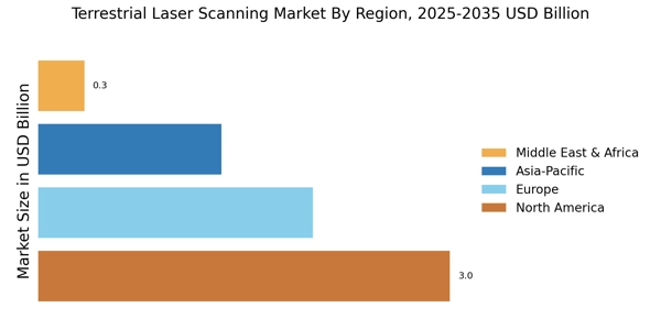
The Terrestrial Laser Scanning Market is poised for considerable growth across its regional segmentation, with North America leading the way.


In 2023, North America was valued at 2.5 USD Billion, dominating the market due to its advanced technology adoption and significant demand from the construction and engineering sectors. Europe followed with a market valuation of 1.8 USD Billion, driven by robust infrastructure projects and increasing applications in heritage conservation.


The APAC region, valued at 1.5 USD Billion in 2023, showed significant potential with rising investments in industrial automation and infrastructure development.


South America, with a valuation of 0.7 USD Billion, was gradually emerging, primarily due to increased awareness of laser scanning technologies. Meanwhile, the MEA region, valued at 0.5 USD Billion, represents the smallest segment, reflecting lower penetration rates and demand variability.


Each regional market plays a vital role in the overall landscape of the Terrestrial Laser Scanning Market, showcasing unique growth drivers and opportunities, particularly in engineering and construction applications.


Terrestrial Laser Scanning Market Regional Insights


Source: Primary Research, Secondary Research, MRFR Database and Analyst Review


Terrestrial Laser Scanning Market Key Players and Competitive Insights:


The competitive landscape of the Terrestrial Laser Scanning Market is marked by rapid technological advancements and increasing demand across various sectors, including construction, surveying, and industrial applications.


The market is characterized by a diverse range of players, from established industry leaders to emerging enterprises, all competing to develop innovative solutions and enhance customer value.


As businesses increasingly recognize the importance of precision measurement and 3D modeling, the competition intensifies, leading to strategic partnerships, mergers, and the introduction of advanced scanning technologies.


The evolving customer needs for accuracy, efficiency, and comprehensive data analysis further drive companies to differentiate their offerings in this crowded market.


Faro Technologies has established itself as a significant player in the Terrestrial Laser Scanning Market, known for its innovative products that enable accurate and reliable measurements crucial for various applications.


The company's strengths lie in its commitment to research and development, resulting in advanced laser scanning solutions that cater to the needs of architects, engineers, and construction professionals. Faro Technologies leverages its experience and expertise to offer high-quality products, which are recognized for their user-friendly interfaces and robust performance.


The strong market presence of Faro Technologies is reinforced by its extensive customer support network, allowing it to respond efficiently to customer inquiries and maintain strong relationships with existing clients.


Additionally, the company's ability to continuously innovate and adapt to market trends further solidifies its competitive position, making it a preferred choice for customers seeking dependable scanning technology.


Trimble stands out as another key player in the Terrestrial Laser Scanning Market, renowned for its robust solutions that integrate advanced technology with software applications. The company's strengths are highlighted by its comprehensive approach to 3D data capturing and modeling, which enhances productivity in sectors such as civil engineering, construction, and mining.


Trimble benefits from a presence, allowing it to serve a wide array of markets while maintaining a strong brand reputation. The company’s commitment to blending smart technology with practical applications enables users to achieve precision and efficiency in their projects.


Furthermore, Trimble’s strategic investments in innovation and collaborative partnerships position it well within the competitive landscape, enabling it to deliver cutting-edge solutions that meet the evolving demands of customers across diverse industries.


Key Companies in the Terrestrial Laser Scanning Market Include


  • Faro Technologies


  • Trimble


  • Velodyne Lidar


  • Maptek


  • Riegl Laser Measurement Systems


  • SICK AG


  • Surphaser


  • Hexagon


  • Leica Geosystems


  • Creaform


  • Teledyne Technologies


  • TOPCON


  • GeoSLAM


  • Optech


Terrestrial Laser Scanning Market Developments


The Terrestrial Laser Scanning Market has been witnessing significant developments recently, particularly involving key players like Faro Technologies, Trimble, Velodyne Lidar, and Riegl Laser Measurement Systems.


As industries increasingly adopt advanced 3D scanning technologies, there is a notable surge in demand for laser scanning solutions across the construction, mining, and surveying sectors.


Companies such as Hexagon and Leica Geosystems are enhancing their product offerings to incorporate AI and automation, aiming to improve precision and efficiency. In terms of market activity, recent mergers and acquisitions have raised interest; for example, Teledyne Technologies has been active in expanding its portfolio through strategic acquisitions, while Topcon has sought to strengthen its market position by integrating innovative scanning technologies from smaller firms.


Additionally, the overall market valuation has experienced growth as investments in research and development and advancements in laser scanning technology propel the sector forward.


Organizations like GeoSLAM and Optech are also noted for their contributions, with new product launches aimed at enhancing user experience and meeting market demand for faster, more accurate scanning solutions. The focus on sustainability and environmental compliance is shaping future developments in the sector.


Terrestrial Laser Scanning Market Segmentation Insights


  • Terrestrial Laser Scanning Market Application Outlook


    • Construction


    • Civil Engineering


    • Heritage Preservation


    • Mining


    • Forestry


  • Terrestrial Laser Scanning Market Scanning Method Outlook


    • Ground-Based Laser Scanning


    • Airborne Laser Scanning


    • Mobile Laser Scanning


    • Terrestrial Laser Scanning


  • Terrestrial Laser Scanning Market End Use Outlook


    • Architecture


    • Land Surveying


    • Agriculture


    • Environmental Monitoring


    • Transportation


  • Terrestrial Laser Scanning Market Component Outlook


    • Hardware


    • Software


    • Services


  • Terrestrial Laser Scanning Market Regional Outlook


    • North America


    • Europe


    • South America


    • Asia Pacific


    • Middle East and Africa


Report Attribute/Metric Details
Market Size 2022 5.69(USD Billion)
Market Size 2023 6.02(USD Billion)
Market Size 2032 10.0(USD Billion)
Compound Annual Growth Rate (CAGR) 5.81% (2024 - 2032)
Report Coverage Revenue Forecast, Competitive Landscape, Growth Factors, and Trends
Base Year 2023
Market Forecast Period 2024 - 2032
Historical Data 2019 - 2023
Market Forecast Units USD Billion
Key Companies Profiled Faro Technologies, Trimble, Velodyne Lidar, Maptek, Riegl Laser Measurement Systems, SICK AG, Surphaser, Hexagon, Leica Geosystems, Creaform, Teledyne Technologies, TOPCON, GeoSLAM, Optech
Segments Covered Application, Scanning Method, End Use, Component, Regional
Key Market Opportunities Increased demand for 3D mapping, Advancements in automation technology, Integration with BIM solutions, Rising investment in infrastructure, and Growth in environmental monitoring applications
Key Market Dynamics Technological advancements in equipment, Increasing demand for 3D modeling, Growth in the construction industry, Rising adoption in infrastructure projects, and the Need for precision and efficiency
Countries Covered North America, Europe, APAC, South America, MEA


Frequently Asked Questions (FAQ) :

The Terrestrial Laser Scanning Market is projected to be valued at 10.0 USD Billion by 2032.

In 2023, the Terrestrial Laser Scanning Market in North America was valued at 2.5 USD Billion.

The expected CAGR for the Terrestrial Laser Scanning Market from 2024 to 2032 is 5.81%.

The Construction segment is anticipated to dominate the market with a projected value of 3.4 USD Billion by 2032.

The Mining application segment is forecasted to grow to 1.6 USD Billion by 2032.

North America is expected to show the greatest growth, rising to 4.1 USD Billion by 2032.

Key players in the market include Faro Technologies, Trimble, Velodyne Lidar, and Riegl Laser Measurement Systems, among others.

The Civil Engineering application segment is projected to reach a value of 2.5 USD Billion by 2032.

The Forestry application segment was valued at 1.72 USD Billion in 2023.

The Heritage Preservation application segment is expected to grow to 1.3 USD Billion by 2032.

Leading companies partner with us for data-driven Insights.

client_1 client_2 client_3 client_4 client_5 client_6 client_7 client_8 client_9 client_10

Kindly complete the form below to receive a free sample of this Report

Please fill in Business Email for Quick Response

We do not share your information with anyone. However, we may send you emails based on your report interest from time to time. You may contact us at any time to opt-out.

Purchase Option
Single User $ 4,950
Multiuser License $ 5,950
Enterprise User $ 7,250
Compare Licenses
Tailored for You
  • Dedicated Research on any specifics segment or region.
  • Focused Research on specific players in the market.
  • Custom Report based only on your requirements.
  • Flexibility to add or subtract any chapter in the study.
  • Historic data from 2014 and forecasts outlook till 2040.
  • Flexibility of providing data/insights in formats (PDF, PPT, Excel).
  • Provide cross segmentation in applicable scenario/markets.