[email protected]   📞 +1 (855) 661-4441(US)   📞 +44 1720 412 167(UK)   📞 +91 2269738890(APAC)
Certified Global Research Member
Isomar 1 Iso 1
Key Questions Answered
  • Global Market Outlook
  • In-depth analysis of global and regional trends
  • Analyze and identify the major players in the market, their market share, key developments, etc.
  • To understand the capability of the major players based on products offered, financials, and strategies.
  • Identify disrupting products, companies, and trends.
  • To identify opportunities in the market.
  • Analyze the key challenges in the market.
  • Analyze the regional penetration of players, products, and services in the market.
  • Comparison of major players financial performance.
  • Evaluate strategies adopted by major players.
  • Recommendations
Why Choose Market Research Future?
  • Vigorous research methodologies for specific market.
  • Knowledge partners across the globe
  • Large network of partner consultants.
  • Ever-increasing/ Escalating data base with quarterly monitoring of various markets
  • Trusted by fortune 500 companies/startups/ universities/organizations
  • Large database of 5000+ markets reports.
  • Effective and prompt pre- and post-sales support.

France Mobile Mapping Market Research Report By Component (Hardware, Software, Services), By Solution (Location-Based, Indoor Mapping, Asset Management, 3D Mapping), By Application (Land Surveys, Aerial Surveys) and By End User (Real Estate & Construction, IT & Telecom, Others) - Forecast to 2035


  • ID: MRFR/ICT/63634-HCR
  • | Pages: 200
  • | Author: Aarti Dhapte
  • | Publish Date: Sep 2025

France Mobile Mapping Market Overview

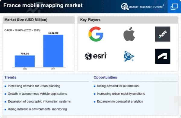
As per MRFR analysis, the France Mobile Mapping Market Size was estimated at 573.86 (USD Million) in 2023. The France Mobile Mapping Market Industry is expected to grow from 635.2(USD Million) in 2024 to 2,131.7 (USD Million) by 2035. The France Mobile Mapping Market CAGR (growth rate) is expected to be around 11.635% during the forecast period (2025 - 2035).

Key France Mobile Mapping Market Trends Highlighted

There are a number of major changes happening in the France Mobile Mapping Market right now. New technologies and a growing need for precise geospatial data are driving these. Mobile mapping solutions are easier to use and more widely available now that more people have smartphones and GPS technology has gotten better. The French government's concentration on digitizing public services and city planning adds to this trend. The National Institute of Geographic and Forest Information in France is very important for getting people to use geospatial technology. This makes it easier for mobile mapping apps to work. 

The France Mobile Mapping Market is opening up new opportunities in several areas, such as transportation, agriculture, and urban development. The French government's support for smart city and sustainable development projects gives us a chance to improve mapping for better environmental monitoring and infrastructure management. By combining mobile mapping with AI and big data analytics, businesses in France may take advantage of these chances. 

Recently, there has been a lot of interest in using mobile mapping for disaster management. Local governments are using these tools to figure out how to respond to disasters and analyze hazards. This trend shows that France is more committed to making people safer and more resilient to natural disasters.There is also more cooperation between public and private sector organizations, which makes it possible to create new mobile mapping solutions that meet the demands of specific areas. This makes urban planning and environmental protection in France more effective overall.

France Mobile Mapping Market size

Source: Primary Research, Secondary Research, MRFR Database and Analyst Review

Growing Demand for Urban Development and Smart Cities

The demand for urban development and the rise of smart city projects in France are driving the France Mobile Mapping Market. As cities evolve and expand, local governments and municipalities are increasingly investing in technologies that provide precise geographical data, leading to improved infrastructure planning and management. According to the French government, the country has outlined plans to invest over 70 billion Euros in sustainable urban development initiatives by 2030, which specifically focuses on enhancing technological frameworks.

This surge in urban reforms presents a substantial market opportunity for mobile mapping, allowing enterprises like Airbus and Orange to leverage mobile mapping solutions for intelligent spatial planning. Moreover, the integration of mobile mapping with the Internet of Things (IoT) facilitates real-time data collection, making it essential for modern urban environments. As smart city initiatives gain momentum, the France Mobile Mapping Market is projected to witness significant growth.

Advancements in Geospatial Technology

Technological advancements in geospatial technologies are a prominent driver for the growth of the France Mobile Mapping Market Industry. The evolution of high-resolution imaging technologies and sensor capabilities has enabled the creation of detailed spatial data. The National Institute of Geographic and Forest Information (Institut national de l'information géographique et forestière, IGN) in France has reported a 30% reduction in costs associated with geospatial data collection due to advancements in mobile mapping technology.

Additionally, the ongoing development of 3D mapping systems and enhanced geographic information systems (GIS) has made mobile mapping more accessible and accurate, allowing companies such as GeoIQ and 3D Mapping Solutions to develop cutting-edge mapping applications. These technological enhancements not only boost the efficiency of data collection but also widen the scope of applications across various sectors, further propelling market growth.

Increased Focus on Accurate Data Collection for Infrastructure Management

The need for accurate data collection for infrastructure management is a key driver for the France Mobile Mapping Market Industry. In light of the European Union's regulations regarding infrastructure and environmental impact assessments, French municipalities are increasingly leveraging mobile mapping technologies to ensure compliance and efficient resource management. 

The French Ministry of Ecological Transition has noted that over 60% of local authorities report challenges in gathering real-time data, which is critical for informed decision-making regarding public utilities and infrastructure maintenance.This emphasizes the rising importance of solutions that not only gather data but also analyze it effectively. Enterprises like Schneider Electric are investing in mobile mapping to innovate their infrastructure management capabilities, thus contributing to market growth.

Growing Applications in Agriculture and Forestry

The application of mobile mapping technologies in the agriculture and forestry sectors is increasing significantly, driving the France Mobile Mapping Market. The French Ministry of Agriculture has projected a 20% increase in the usage of precision agriculture tools by 2025, as farmers seek to optimize yields and manage crop health more effectively. Mobile mapping allows for detailed surveying of agricultural land, helping farmers make data-driven decisions.

Additionally, initiatives such as the French National Forest Inventory leverage mobile mapping tools to monitor forest conditions and ensure sustainable practices. Companies such as Agreenculture are already using these tools to enable precision farming. The agritech sector's rapid growth underscores the critical role of mobile mapping in promoting sustainable agriculture and forestry practices.

France Mobile Mapping Market Segment Insights

Mobile Mapping Market Component Insights

The Component segment of the France Mobile Mapping Market encompasses a diverse array of elements, which are essential in catering to the growing demands for precision mapping solutions in various sectors such as transportation, urban planning, and environmental monitoring. This segment is primarily divided into three key categories: Hardware, Software, and Services, each playing a distinctive role in enhancing mobile mapping capabilities. Hardware includes advanced sensors, cameras, and lidar technology that facilitate accurate data acquisition and high-resolution mapping, making it indispensable for applications requiring real-time data collection and analysis.

The Software component focuses on the processing, management, and visualization of the mapping data collected, enabling users to interpret the information effectively and make data-driven decisions. Software solutions often integrate geographic information systems and analytical tools that support various industries in their operational planning and strategic initiatives. Meanwhile, Services encompasses a range of offerings, including training, technical support, and consulting that assist users in leveraging mapping technologies for optimum results.

Given France's commitment to digital innovation and smart city initiatives, the demand for integrated mobile mapping solutions continues to grow. The convergence of these three components positions the France Mobile Mapping Market as a pivotal player in the development of modern infrastructure, urban planning, and environmental management. The presence of stringent regulations and increasing investments in Research and Development activities further bolsters the competitive landscape, leading to new opportunities for growth. 

The integration of new technologies, such as artificial intelligence and machine learning, into mobile mapping services emphasizes the potential for revolutionary advancements in data analysis and application.Collectively, these components are crucial for enhancing the navigational accuracy and operational efficiency of various industries throughout France, providing valuable insights that drive informed decision-making processes.

France Mobile Mapping Market Segment

Source: Primary Research, Secondary Research, MRFR Database and Analyst Review

Mobile Mapping Market Solution Insights

The France Mobile Mapping Market focuses significantly on the Solution segment, which plays a crucial role in enhancing spatial data accuracy and operational efficiency across various industries. Within this segment, Location-Based services dominate, offering real-time navigation and improved customer experiences, which are vital in urban planning and transportation sectors in France. Indoor Mapping solutions have gained traction due to the rise of smart buildings and the need for efficient space utilization, particularly in large venues and commercial complexes.Asset Management solutions are becoming increasingly significant as organizations seek to optimize resource allocation and maintenance planning, ensuring longevity in assets. 

Moreover, 3D Mapping technology is making strides in visualizing in-depth geographic information, which is essential for construction, architecture, and city management in the growing urban landscapes of France. The growing demand for enhanced mapping technologies and spatial analysis is driven by the increasing integration of smart technologies in various sectors, indicating a vibrant landscape for the France Mobile Mapping Market with diverse applications and opportunities for growth in the years to come.

Mobile Mapping Market Application Insights

The France Mobile Mapping Market focuses significantly on various applications that are fundamentally important for the country's development and infrastructure projects. Among these applications, Land Surveys and Aerial Surveys play critical roles in enhancing accuracy and efficiency in data collection and analysis. Land Surveys are vital for urban planning, construction, and environmental management, ensuring land use complies with regulations while facilitating meticulous geographical assessments. Meanwhile, Aerial Surveys leverage advanced technology for capturing large areas quickly, which is crucial for agriculture, forestry, and disaster management.Government initiatives promoting digital transformation and sustainable development further drive the uptake of these applications, as they provide essential insights for decision-making processes. 

The integration of mobile mapping technologies allows organizations to gather precise geospatial data efficiently, addressing the growing demand for accuracy in various sectors. Furthermore, the increased investment in infrastructure projects across France highlights the importance of these applications, cementing their role as essential tools in the ongoing evolution of the French Mobile Mapping Market industry.Overall, both applications are expected to contribute significantly to the market growth as they align with France's strategic vision for smart cities and integrated planning solutions.

Mobile Mapping Market End User Insights

The France Mobile Mapping Market showcases a robust segmentation based on end-user applications, prominently featuring industries such as Real Estate and Construction, IT and Telecom, among others. The Real Estate and Construction sector leverages mobile mapping technology to streamline property evaluations, optimize site planning, and enhance project visualizations, emphasizing the significance of accurate spatial data in development projects. Similarly, the IT and Telecom industry benefits from mobile mapping through improved infrastructure management and network deployment strategies, ensuring efficient service delivery.

The diversity within the end-user segment reveals the widespread applicability of mobile mapping solutions across various fields. As these industries continue to evolve, driven by the growing demand for precision and efficiency, the integration of cutting-edge mobile mapping technologies is expected to further enhance operational capabilities and contribute positively to the overall advancement of the France Mobile Mapping Market. The increasing focus on data-driven decision-making across sectors signals substantial growth potential, making it a pivotal area for market stakeholders.

France Mobile Mapping Market Key Players and Competitive Insights

The France Mobile Mapping Market showcases a dynamic landscape characterized by rapid technological advancements and a growing demand for efficient mapping solutions across various sectors. The competitive insights within this market highlight the emergence of numerous players as they endeavor to establish their presence in this burgeoning domain. The market is driven by a confluence of factors, including the increasing adoption of geospatial data for urban planning, transportation, and environmental monitoring, coupled with the ongoing advancements in drone technology and geographic information systems. This competitive environment fosters innovation and collaboration among companies striving to capture market share and differentiate their offerings through advanced technologies and improved service delivery.

In the context of the France Mobile Mapping Market, SenseFly stands out as a key player known for its innovative drone-based mapping solutions. The company has established a robust presence in France due to its focus on high-quality aerial imagery and geospatial data collection. SenseFly's strengths lie in its advanced drone technology that allows for efficient mapping over large areas, making it an attractive option for industries such as agriculture, construction, and environmental monitoring. By providing detailed and accurate data, SenseFly supports businesses in making informed decisions, optimizing workflows, and enhancing productivity. The company’s continual investment in research and development ensures its offerings are at the forefront of technological advancements, allowing it to maintain a competitive edge within the market.

On the other hand, Google holds a strong position within the France Mobile Mapping Market, primarily through its extensive range of products and services that utilize geospatial data. Among its notable offerings are Google Maps and Google Earth, which leverage mobile mapping technologies to provide users with comprehensive mapping solutions. Google's strengths in this market stem from its vast pool of resources, innovative technologies, and user-friendly interfaces, facilitating access to mapping information on a global scale. 

In France, Google has been active in establishing partnerships and collaborations that enhance its service capabilities while continuously expanding its mapping database. The company’s commitment to improving accuracy and user experience through regular updates and enhancements further solidifies its position. Additionally, any recent mergers and acquisitions aimed at integrating advanced mapping technologies into its platform contribute to its growth, enabling Google to capitalize on emerging trends within the mobile mapping sphere in France.

Key Companies in the France Mobile Mapping Market Include:

  • SenseFly
  • Google
  • Atkins
  • Naviguero
  • Geoconcept
  • TomTom
  • CARTO
  • Fugro
  • Saarthak Tech
  • Hexagon AB
  • Esri
  • Mapbox
  • Trimble
  • Here Technologies

France Mobile Mapping Market Industry Developments

Significant advancements and activities have marked recent developments in the France Mobile Mapping Market. Companies such as senseFly and Geoconcept have continued to innovate with drone technology and geographic information systems, enhancing mapping capabilities and efficiency.

In July 2025, French geospatial companies worked with tech companies to make integrated mobile mapping systems that use AI and IoT to keep an eye on cities in real time. This helped smart city projects and made cities safer. In early 2025, a big European mobile mapping business released a new, lighter LiDAR system in France. It was made for inspecting infrastructure and managing construction projects, and it had faster and more accurate scanning capabilities. In 2025, France's government-backed digital transformation projects encouraged mobile mapping firms and city planners to work together to use advanced 3D mapping and digital twin technologies for long-term urban growth and monitoring the environment.

As the demand for smart city solutions rises within France, collaboration between companies like Atkins, Naviguero, and HEXAGON has been instrumental in shaping mobile mapping solutions to meet regulatory requirements and consumer needs. This collaborative approach is driving the evolution of mobile mapping technology significantly across the region.

France Mobile Mapping Market Segmentation Insights

Mobile Mapping Market Component Outlook

    • Hardware
    • Software
    • Services

Mobile Mapping Market Solution Outlook

    • Location-Based
    • Indoor Mapping
    • Asset Management
    • 3D Mapping

Mobile Mapping Market Application Outlook

    • Land Surveys
    • Aerial Surveys

Mobile Mapping Market End User Outlook

    • Real Estate & Construction
    • IT & Telecom
    • Others
 
Report Attribute/Metric Source: Details
MARKET SIZE 2023 573.86(USD Million)
MARKET SIZE 2024 635.2(USD Million)
MARKET SIZE 2035 2131.7(USD Million)
COMPOUND ANNUAL GROWTH RATE (CAGR) 11.635% (2025 - 2035)
REPORT COVERAGE Revenue Forecast, Competitive Landscape, Growth Factors, and Trends
BASE YEAR 2024
MARKET FORECAST PERIOD 2025 - 2035
HISTORICAL DATA 2019 - 2024
MARKET FORECAST UNITS USD Million
KEY COMPANIES PROFILED SenseFly, Google, Atkins, Naviguero, Geoconcept, TomTom, CARTO, Fugro, Saarthak Tech, Hexagon AB, Esri, Mapbox, Trimble, Here Technologies
SEGMENTS COVERED Component, Solution, Application, End User
KEY MARKET OPPORTUNITIES Increased urbanization and infrastructure development, Demand for high-resolution mapping data, Advancements in drone and sensor technology, Growing adoption in smart city initiatives, Integration with GIS and spatial analytics
KEY MARKET DYNAMICS Technological advancements, Increasing demand for accuracy, Growth of smart city initiatives, Expansion of geospatial data usage, Rise in autonomous vehicle applications
COUNTRIES COVERED France


Frequently Asked Questions (FAQ):

The France Mobile Mapping Market is expected to be valued at 635.2 million USD in 2024.

By 2035, the overall market is expected to reach a value of 2.131.7 billion USD.

The market is anticipated to experience a CAGR of 11.635% during the forecast period from 2025 to 2035.

Major players in the market include SenseFly, Google, Atkins, Naviguero, and Geoconcept among others.

The hardware segment is projected to be valued at 850.0 million USD by 2035.

The software segment is expected to reach a value of 700.0 million USD by 2035.

The services segment is anticipated to be valued at approximately 185.2 million USD in 2024 and expected to grow significantly by 2035.

Key applications include urban planning, transportation, and infrastructure development.

The market has seen growth driven by advancements in technology and increasing demand for accurate mapping solutions.

Emerging trends such as increased investment in geographic information systems and smart city initiatives present significant growth opportunities.

Comments

Leading companies partner with us for data-driven Insights.

clients

Kindly complete the form below to receive a free sample of this Report

We do not share your information with anyone. However, we may send you emails based on your report interest from time to time. You may contact us at any time to opt-out.

Tailored for You
  • Dedicated Research on any specifics segment or region.
  • Focused Research on specific players in the market.
  • Custom Report based only on your requirements.
  • Flexibility to add or subtract any chapter in the study.
  • Historic data from 2014 and forecasts outlook till 2040.
  • Flexibility of providing data/insights in formats (PDF, PPT, Excel).
  • Provide cross segmentation in applicable scenario/markets.
report-img