[email protected]   📞 +1 (855) 661-4441(US)   📞 +44 1720 412 167(UK)   📞 +91 2269738890(APAC)
Certified Global Research Member
Isomar 1 Iso 1
Key Questions Answered
  • Global Market Outlook
  • In-depth analysis of global and regional trends
  • Analyze and identify the major players in the market, their market share, key developments, etc.
  • To understand the capability of the major players based on products offered, financials, and strategies.
  • Identify disrupting products, companies, and trends.
  • To identify opportunities in the market.
  • Analyze the key challenges in the market.
  • Analyze the regional penetration of players, products, and services in the market.
  • Comparison of major players financial performance.
  • Evaluate strategies adopted by major players.
  • Recommendations
Why Choose Market Research Future?
  • Vigorous research methodologies for specific market.
  • Knowledge partners across the globe
  • Large network of partner consultants.
  • Ever-increasing/ Escalating data base with quarterly monitoring of various markets
  • Trusted by fortune 500 companies/startups/ universities/organizations
  • Large database of 5000+ markets reports.
  • Effective and prompt pre- and post-sales support.

Canada Mobile Mapping Market Research Report By Component (Hardware, Software, Services), By Solution (Location-Based, Indoor Mapping, Asset Management, 3D Mapping), By Application (Land Surveys, Aerial Surveys) and By End User (Real Estate & Construction, IT & Telecom, Others) - Forecast to 2035


  • ID: MRFR/ICT/63635-HCR
  • | Pages: 200
  • | Author: Aarti Dhapte
  • | Publish Date: Sep 2025

Canada Mobile Mapping Market Overview

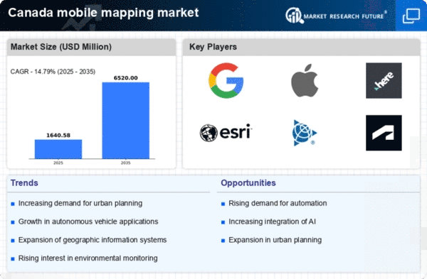
As per MRFR analysis, the Canada Mobile Mapping Market Size was estimated at 2.15 (USD Billion) in 2023. The Canada Mobile Mapping Market Industry is expected to grow from 2.5(USD Billion) in 2024 to 8 (USD Billion) by 2035. The Canada Mobile Mapping Market CAGR (growth rate) is expected to be around 11.153% during the forecast period (2025 - 2035).

Key Canada Mobile Mapping Market Trends Highlighted

The Canada Mobile Mapping Market is growing quickly right now because there is a growing need for mapping solutions that are both accurate and quick. The growth of mobile devices with improved sensors and GPS technology is a major factor in the industry, as it allows organizations to gather geospatial data more quickly and accurately. Transportation, urban planning, and environmental management are just a few of the fields looking for new mapping tools to help them make better decisions. 

Also, the growth of smart city projects across Canada is making people want to use mobile mapping technologies to improve public services and infrastructure. There are several chances to be taken advantage of in the Canadian mobile mapping market. As more businesses see the benefit of real-time data, companies that offer integrated mapping solutions may take advantage of this trend. Businesses, government agencies, and academic institutes might potentially work together to make advanced mobile mapping apps that meet Canada's specific needs, like keeping an eye on natural resources or controlling urban sprawl. 

The growing focus on protecting the environment and being sustainable opens up more ways for mobile mapping to help with eco-friendly planning and catastrophe response.Recent trends show that mobile mapping solutions are becoming more focused on automation and artificial intelligence. Automation makes it easier to collect and process data, while AI makes it easier to analyze data, which leads to more accurate insights. 

Also, more and more people are combining mobile mapping with new technology like drones and LiDAR. This opens up new opportunities for high-resolution mapping in many types of terrain across Canada. The mobile mapping market is ready to grow as provinces keep spending money on digital infrastructure. This is because the needs and details of the Canadian landscape are always changing.

Canada Mobile Mapping Market size

Source: Primary Research, Secondary Research, MRFR Database and Analyst Review

Growing Demand for GIS Solutions in Canada

The increasing adoption of Geographic Information System (GIS) technology in Canada is a prominent driver for the Canada Mobile Mapping Market Industry. According to a report from the Government of Canada, the use of GIS has expanded by approximately 25% over the last five years across various sectors such as urban planning, transportation, and environmental management. 

Organizations like Esri Canada are heavily investing in Research and Development to enhance GIS technology tailored for Canadian applications.With cities like Toronto and Vancouver emphasizing smart city initiatives, there is a strong push for understanding spatial data through mobile mapping solutions. The Canadian government has allocated funds towards digital infrastructure, supporting an implication that mobile mapping will play a significant role in the modernization of infrastructure across the country. As such, the increasing focus on GIS solutions drives the demand for mobile mapping technologies.

Technological Advancements in Mobile Mapping

Rapid advancements in mobile mapping technologies, such as LiDAR (Light Detection and Ranging) and 3D modeling tools, are propelling the Canada Mobile Mapping Market Industry. With increased investment in technology by companies such as Teledyne Technologies, the accuracy of mobile mapping has improved significantly. 

The Canadian government has witnessed a trend where over 50% of municipalities in British Columbia now utilize advanced mapping technologies to manage and analyze geographic data.Such technological advancements not only provide better quality data but also enhance the efficiency of planning and development processes, driving further adoption across various industries.

Increase in Infrastructure Development Projects

The resurgence of infrastructure development in Canada, fueled by government initiatives aimed at revamping public transport and urban areas, is significantly impacting the Canada Mobile Mapping Market Industry. The Government of Canada has announced an investment of over CAD 33 billion in various infrastructure projects over the next decade, including bridges, roads, and transit systems. 

According to recent statistics, approximately 65% of municipal councils in Canada are currently engaged in infrastructure enhancement projects, thereby creating a robust demand for mobile mapping solutions that offer precise measurements and real-time data collection.Companies like Autodesk are responding to this growth by innovating software platforms that incorporate mobile mapping to improve project outcomes.

Increasing Focus on Environmental Monitoring and Sustainable Development

With Canada’s commitment to sustainable development, there is a marked increase in the focus on environmental monitoring, which is significantly benefiting the Canada Mobile Mapping Market Industry. The Canadian Environmental Sustainability Indicators (ESI) initiative has shown that around 70% of Canadians support the use of technology for environmental protection. 

As municipalities strive to meet environmental regulations and sustainability goals, mobile mapping technologies provide an efficient means to monitor land use, vegetation health, and natural resource management.Organizations such as the Canadian Council of Ministers of the Environment are advocating for the integration of mobile mapping in conservation efforts, further driving growth in this segment.

Canada Mobile Mapping Market Segment Insights

Mobile Mapping Market Component Insights

The Canada Mobile Mapping Market, characterized by its robust growth and technological advancements, is significantly driven by its Component segment, which encompasses Hardware, Software, and Services. Within Hardware, the integration of high-resolution sensors and cameras is essential for accurate data collection, facilitating applications in urban planning, environmental monitoring, and autonomous vehicles. The growing need for precision in geospatial data has amplified the importance of these components in various sectors, including construction, telecommunications, and transportation, particularly as Canada is known for its vast land and diverse geographic features, necessitating effective mapping solutions.

Software plays a critical role in the Mobile Mapping Market by providing sophisticated algorithms for data processing, analysis, and visualization. With the rise of smart cities and Internet of Things (IoT) applications, the demand for advanced software solutions that can handle big data analytics and real-time processing is on the rise. The emphasis on security and software efficiency is also becoming increasingly important as digital mapping integrates deeper with everyday applications.

Services associated with mobile mapping are pivotal as they include consulting, data acquisition, and maintenance, ensuring that the mapped data is actionable and useful for end-users. Service providers are increasingly focusing on customer-centric solutions, emphasizing the importance of tailored mapping services to meet the specific demands of various industries, from logistics to emergency response. The interplay between these three components strengthens the Canada Mobile Mapping Market, as they collectively contribute to higher operational efficiency and extensive data usage. The synergy between Hardware, Software, and Services fosters innovation and enhancement in mobile mapping technologies, making it a vital component of Canada's evolving digital landscape and positioning it for sustained market growth in the coming years.

Canada Mobile Mapping Market Segment

Source: Primary Research, Secondary Research, MRFR Database and Analyst Review

Mobile Mapping Market Solution Insights

The Canada Mobile Mapping Market, particularly within the Solution segment, is characterized by its diverse applications and growing significance across various sectors. This segment encompasses key areas, including Location-Based services, Indoor Mapping, Asset Management, and 3D Mapping, each contributing uniquely to the market's growth. Location-based services are increasingly being adopted in Canada to enhance navigation and provide real-time data, aiding businesses in optimizing their operations and improving customer experiences. Indoor Mapping has gained traction as businesses look to improve spatial awareness in commercial spaces, enhancing accessibility and user engagement.

Asset Management strategies are becoming critical for industries such as logistics and infrastructure, allowing for efficient tracking and management of resources. Meanwhile, 3D Mapping offers crucial insights into geographical data, facilitating urban planning and development across the nation. The integration of advanced technologies, along with the increasing emphasis on transportation safety and infrastructure development, further strengthens the importance of these services. As Canada's economy continues to digitize, the demand for innovative mobile mapping solutions is expected to grow, driving further advancements in this market sector and enhancing productivity across multiple industries.

Mobile Mapping Market Application Insights

The Canada Mobile Mapping Market has experienced significant growth within the Application segment, driven primarily by the increasing demand for accurate geographic data across various industries. The relevance of Land Surveys cannot be overstated, as they play a crucial role in real estate, construction, and infrastructure development, allowing for detailed mapping and analysis of land use and property boundaries. Aerial Surveys, on the other hand, are gaining traction due to advancements in drone technology and remote sensing, facilitating the collection of high-resolution data for environmental monitoring, urban planning, and resource management.

These applications cater to the needs of government agencies and private firms in Canada, ensuring efficient project execution and compliance with regulations. The market dynamics are influenced by factors such as technological advancements, the need for data-driven decision-making, and the rising frequency of urban development projects across Canadian provinces. The importance of mobile mapping technologies for creating comprehensive geographic information systems is poised to provide opportunities for further innovation and enhance efficiency across various sectors in Canada.

Mobile Mapping Market End User Insights

The Canada Mobile Mapping Market is significantly influenced by various end users, who play crucial roles in the application and growth of mobile mapping technologies. In the Real Estate and Construction sector, mobile mapping tools enhance project planning and management, allowing for efficient site assessments and visualizations. These tools are essential for generating accurate geospatial data that aids in the design and execution of construction projects. The IT and Telecom sector also holds a vital position, with mobile mapping facilitating network planning, asset management, and infrastructure development, ensuring optimal service delivery in urban and rural areas.

Moreover, the presence of diverse industries in the 'Others' category, including transportation, utilities, and public safety, underscores the versatile applications of mobile mapping technologies across Canada. Given the country's vast geography, the demand for precise mapping solutions continues to rise, driven by urbanization and advancements in technology. As Canadian enterprises increasingly recognize the strategic importance of accurate geospatial data, the overall market expanded and diversified within these end-user segments, highlighting the continuous evolution and integration of mobile mapping into everyday operations.

Canada Mobile Mapping Market Key Players and Competitive Insights

The Canada Mobile Mapping Market is characterized by a dynamic landscape driven by technological advancements and evolving customer needs. This market encompasses a range of services and products that facilitate the capture, analysis, and visualization of geospatial data through mobile mapping technologies. Competitive insights reveal that companies operating within this sector must navigate a variety of challenges, including the need for continuous innovation, strategic partnerships, and effective marketing strategies to differentiate themselves from competitors. The demand for high-precision mapping solutions across industries such as construction, transportation, and urban planning fuels the race among companies to secure a substantial market footprint. 

Topcon has established a solid presence in the Mobile Mapping Market in Canada, renowned for its innovative approach to geospatial solutions. The company offers a portfolio of advanced mobile mapping systems that are designed for accuracy and efficiency. Topcon's strengths in this market include its commitment to research and development, which allows it to stay ahead of technology trends and meet the diverse needs of its customers. The firm's extensive network of distributors and partners enhances its reach within the Canadian market, ensuring that clients have access to reliable products and services. 

Furthermore, Topcon's emphasis on customer support and training ensures that users can maximize the value of their mapping solutions.Hexagon operates with a significant presence in the Canada Mobile Mapping Market, leveraging its expertise in digital solutions and engineering software to provide cutting-edge mapping technologies. The company’s portfolio includes powerful products and services aimed at improving data collection and analysis for surveying and mapping applications. 

Hexagon's strengths lie in its integration of advanced technologies such as artificial intelligence and cloud computing, which enhance the capability and efficiency of its mobile mapping systems. The company has made strategic investments in research and development, alongside numerous partnerships and acquisitions, which bolster its portfolio and market competitiveness in Canada. These efforts underscore Hexagon’s commitment to maintaining a leading position in the fast-evolving landscape of mobile mapping through innovative solutions tailored to the needs of the Canadian market.

Key Companies in the Canada Mobile Mapping Market Include:

  • Topcon
  • Hexagon
  • Leica Geosystems
  • Fugro
  • GeoSLAM
  • Pix4D
  • Esri
  • Trimble
  • Riegl

Canada Mobile Mapping Market Industry Developments

Recent developments in the Canada Mobile Mapping Market have showcased significant growth, particularly influenced by advancements in technology and increased investments from key players such as Topcon, Hexagon, and Fugro.

In November 2024, Canadian sustainable asset management company Can-Explore formed a strategic partnership with Jakarto, a leader in 3D mapping and geospatial data management, to enhance data collection and certification for infrastructure projects using advanced mobile mapping technology.In early 2025, major mobile mapping firms introduced innovative lightweight and faster scanning 3D mobile mapping systems integrated with advanced sensors, improving data accuracy and efficiency for urban planning and infrastructure management in Canada.

Throughout 2025, strategic collaborations among Canadian technology providers and international mapping firms intensified to expand mobile mapping applications in smart city projects, environmental monitoring, and transportation infrastructure development. These efforts are supported by government initiatives promoting digital transformation and sustainable urban growth.In terms of mergers and acquisitions, Hexagon and Trimble have been exploring strategic partnerships to enhance their offerings, although no specific transactions have been disclosed recently.

The market has experienced a surge in valuation, driven by increasing applications across various sectors such as construction, mining, and environmental monitoring. This growth reflects Canada’s commitment to leveraging modern technologies for enhanced data collection and analysis. Over the past few years, companies like Pix4Dmapper and SenseFly have also expanded their portfolios, contributing to the competitive landscape within the mobile mapping domain in Canada.

Canada Mobile Mapping Market Segmentation Insights

Mobile Mapping Market Component Outlook

    • Hardware
    • Software
    • Services

Mobile Mapping Market Solution Outlook

    • Location-Based
    • Indoor Mapping
    • Asset Management
    • 3D Mapping

Mobile Mapping Market Application Outlook

    • Land Surveys
    • Aerial Surveys

Mobile Mapping Market End User Outlook

    • Real Estate & Construction
    • IT & Telecom
    • Others
 
Report Attribute/Metric Source: Details
MARKET SIZE 2023 2.15(USD Billion)
MARKET SIZE 2024 2.5(USD Billion)
MARKET SIZE 2035 8.0(USD Billion)
COMPOUND ANNUAL GROWTH RATE (CAGR) 11.153% (2025 - 2035)
REPORT COVERAGE Revenue Forecast, Competitive Landscape, Growth Factors, and Trends
BASE YEAR 2024
MARKET FORECAST PERIOD 2025 - 2035
HISTORICAL DATA 2019 - 2024
MARKET FORECAST UNITS USD Billion
KEY COMPANIES PROFILED Topcon, Hexagon, MAPPING, SenseFly, Pix4Dmapper, Leica Geosystems, Skycatch, Fugro, Vexcel Imaging, GeoSLAM, Pix4D, NavVis, Esri, Trimble, Riegl
SEGMENTS COVERED Component, Solution, Application, End User
KEY MARKET OPPORTUNITIES Rapid urbanization and infrastructure growth, Increased demand for accurate geospatial data, Technological advancements in mapping solutions, Integration with smart city initiatives, Expansion in autonomous vehicle applications
KEY MARKET DYNAMICS technological advancements, increasing demand for GIS, urbanization and infrastructure development, government initiatives and funding, rise in autonomous vehicles
COUNTRIES COVERED Canada


Frequently Asked Questions (FAQ):

The Canada Mobile Mapping Market is expected to be valued at 2.5 billion USD in 2024.

By 2035, the market is projected to reach a value of 8.0 billion USD.

The expected CAGR for the Canada Mobile Mapping Market during this period is 11.153 percent.

The hardware segment is projected to reach 3.2 billion USD by 2035.

The software segment is expected to be valued at 2.5 billion USD by 2035.

The services segment is projected to grow to 2.3 billion USD by 2035.

Key players in the market include Topcon, Hexagon, MAPPING, and SenseFly among others.

Applications such as urban planning, transportation management, and infrastructure development are driving growth.

The hardware component currently holds the largest share of the market.

Emerging trends include advancements in sensor technologies and increased adoption of AI in mapping solutions.

Comments

Leading companies partner with us for data-driven Insights.

clients

Kindly complete the form below to receive a free sample of this Report

We do not share your information with anyone. However, we may send you emails based on your report interest from time to time. You may contact us at any time to opt-out.

Tailored for You
  • Dedicated Research on any specifics segment or region.
  • Focused Research on specific players in the market.
  • Custom Report based only on your requirements.
  • Flexibility to add or subtract any chapter in the study.
  • Historic data from 2014 and forecasts outlook till 2040.
  • Flexibility of providing data/insights in formats (PDF, PPT, Excel).
  • Provide cross segmentation in applicable scenario/markets.
report-img