Segmentation Quick Reference
| Dimension | Sub-Segments | Dominant Segment | Fastest Growing Segment |
| Component | Software, Services, Hardware | Software | Services |
| Analysis Type | Surface Analysis, Network Analysis, Other Analysis Types | Surface Analysis | Network Analysis |
| Deployment Model | Cloud, On-Premises | Cloud | Cloud |
| End-User Vertical | Government, Defense & Intelligence, Natural Resources, Utility & Communication, Transportation & Logistics, Other Verticals | Government | Transportation & Logistics |
| Region | North America, Europe, Asia-Pacific, South America, Middle East & Africa | North America | Asia-Pacific |
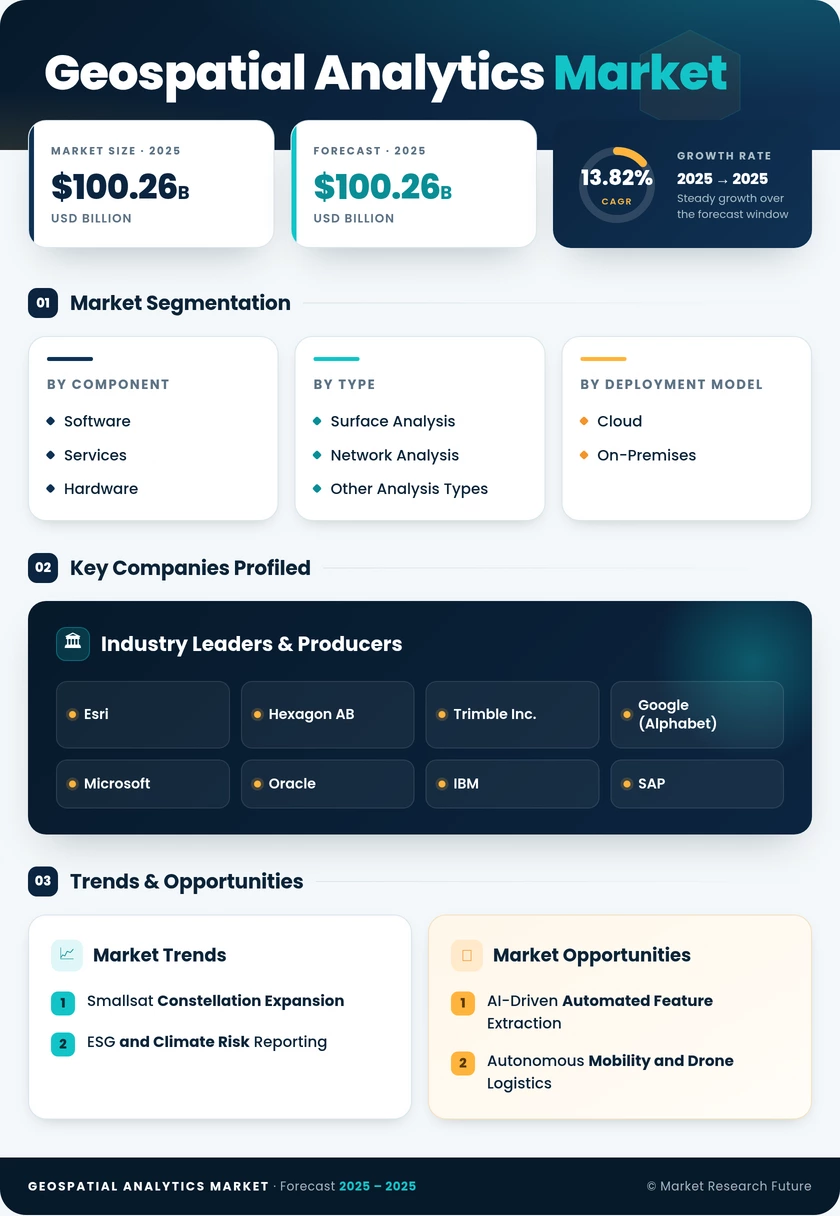
Market Segmentation Overview
By Component
| Sub-Segment | Key Trend |
| Software | Migration to cloud-native SaaS GIS platforms with AI-embedded analytics |
| Services | Growth in managed geospatial services and system integration consulting |
| Hardware | Declining LiDAR and sensor costs driving broader adoption |
The component dimension reflects a structural shift from capital-intensive hardware procurement toward recurring software subscriptions and outsourced service engagements. Software platforms increasingly bundle spatial data visualization, GIS data analysis, and AI model hosting into unified offerings.
By Analysis Type
| Sub-Segment | Key Trend |
| Surface Analysis | Foundation for terrain modeling, land-use classification, and flood mapping |
| Network Analysis | Rapid adoption in logistics routing and utility grid optimization |
| Other Analysis Types | Geostatistical modeling, proximity analysis, and spatial clustering expanding |
Surface analysis remains foundational because nearly every geospatial workflow begins with terrain or land-cover data. Network analysis is accelerating as supply-chain and utility operators seek real-time optimization through geographic information systems.
By Deployment Model
| Sub-Segment | Key Trend |
| Cloud | Hyperscaler GIS services enable elastic, pay-as-you-go spatial processing |
| On-Premises | Retained by defense and regulated industries requiring air-gapped environments |
Cloud deployment crossed the majority threshold as AWS, Azure, and Google Cloud launched purpose-built geospatial services. On-premises installations persist where data sovereignty and classification requirements prevent external hosting.
By End-User Vertical
| Sub-Segment | Key Trend |
| Government | Largest buyer; census, land administration, and disaster response applications |
| Defense & Intelligence | ISR modernization and terrain analysis driving sustained investment |
| Natural Resources | Mining, forestry, and oil & gas exploration leveraging remote sensing |
| Utility & Communication | 5G tower siting and distributed energy asset management |
| Transportation & Logistics | Fastest-growing vertical; route optimization and HD mapping demand |
| Other Verticals | Insurance, retail, real estate, and healthcare adopting location intelligence |
Transportation and logistics are emerging as the highest-growth vertical as freight operators integrate real-time location intelligence software for fleet optimization and last-mile delivery routing, while government agencies remain the anchor demand source for the Geospatial Analytics Market.
By Region
| Sub-Segment | Key Trend |
| North America | Federal modernization and autonomous vehicle mapping lead demand |
| Europe | Copernicus open data and CSRD compliance fuel analytics adoption |
| Asia-Pacific | Smart-city initiatives and open-data mandates drive the fastest growth |
| South America | Deforestation monitoring and precision agriculture anchor spending |
| Middle East & Africa | Megaproject procurement and oil & gas asset management |
Regional dynamics reflect varying stages of digital infrastructure maturity. North America leads on vendor density and federal spending, while Asia-Pacific's rapid urbanization and policy openness position it as the primary growth engine for the Geospatial Analytics Market through 2035.