Drone Analytics Market

Key Players: DroneDeploy, Pix4D, Propeller Aero, PrecisionHawk, Sentera, Skydio, Delair, DJI (Terra/FlightHub)

Drone Analytics Market

Drone Analytics Market Size, Share, Industry Trend & Analysis Research Report Information By Application (Construction, Agriculture, Energy, Law Enforcement, Other Industries), By Component (Software Platforms, Services Infrastructure (Cloud/Edge)) – Forecast 2035
ID: MRFR/AD/6442-HCR
133 Pages
Abbas Raut, Sejal Akre
Last Updated: June 23, 2026
 

Drone Analytics Market Summary

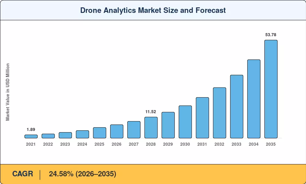
The Drone Analytics Market reached an estimated USD 5.96 billion in 2025 and is projected to grow from USD 7.42 billion in 2026 to USD 53.78 billion by 2035, registering a CAGR of 24.58% during the forecast period (2026–2035). This expansion is propelled by rapid commercial drone adoption across construction, agriculture, and energy sectors, alongside regulatory shifts such as the FAA's expanded BVLOS (Beyond Visual Line of Sight) authorizations and the European Union Aviation Safety Agency's updated U-space framework [2]. Government infrastructure spending — including the USD 1.2 trillion U.S. Infrastructure Investment and Jobs Act — has created enormous demand for aerial data visualization tools that support bridge inspections, road surveys, and utility corridor mapping [3].

A fundamental technology shift is reshaping the Drone Analytics Market as legacy manual survey methods and ground-based inspection workflows give way to automated UAV data processing platforms powered by edge computing and deep learning. Enterprise drone AI analytics software now processes terabytes of photogrammetry, LiDAR, and multispectral data in near real time, replacing weeks of manual analysis with hours of automated insight generation. BloombergNEF estimates that global investment in commercial drone technology exceeded USD 6.8 billion in 2024, with analytics software capturing a growing share of that spend [4].

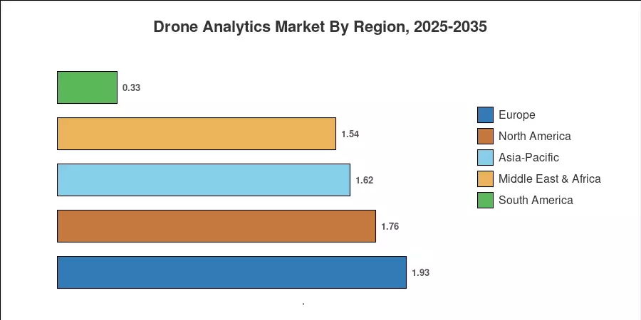
Europe currently commands the largest share of the Drone Analytics Market at approximately 32.4%, driven by strict asset inspection mandates across oil and gas infrastructure and wind energy installations. Asia-Pacific is the fastest-growing region with a CAGR exceeding 27.1%, fueled by aggressive drone fleet management analytics deployments in China, India, and Japan. North America holds the second-largest share at around 29.6%, anchored by defense-related surveillance analytics and precision agriculture programs The Drone Analytics Market is poised for accelerated growth as machine learning drone inspection capabilities mature and autonomous flight corridors scale across commercial airspace.


Key Report Takeaways

• By Application

  • Construction holds the largest revenue share in the Drone Analytics Market, commanding approximately 28.5% of total value in 2025, driven by demand for site progress monitoring and volumetric measurement using aerial data visualization tools
  • Agriculture is the fastest-growing application segment with a CAGR of 27.3% through 2035, as precision farming programs integrate drone AI analytics software for crop health assessment and yield prediction
  • Energy applications generated an estimated USD 1.13 billion in 2025, reflecting expanding use of machine learning drone inspection for wind turbines, solar farms, and pipeline corridors

• By Component

  • Software platforms — including UAV data processing platform solutions — account for the dominant revenue share in the Drone Analytics Market, reflecting the shift from hardware-centric to analytics-centric value chains
  • Services (consulting, data processing, managed analytics) represent the fastest-growing component segment, registering a CAGR of 26.8% as enterprises outsource drone fleet management analytics to specialized providers

• By Region

  • Europe leads the Drone Analytics Market with a 32.4% share, driven by regulatory mandates for infrastructure inspection and environmental monitoring across EU member states
  • Asia-Pacific posts the highest growth trajectory at 27.1% CAGR, with China and India emerging as focal points for large-scale aerial data visualization tools deployment
  • North America contributes approximately USD 1.76 billion in 2025, with the U.S. accounting for over 82% of regional revenue


Market Size and Forecast (2021–2035)

MRFR's sizing methodology integrates bottom-up revenue modeling from vendor financial disclosures, validated against top-down macroeconomic indicators including commercial drone shipment volumes, enterprise software licensing trends, and government procurement databases. Historical figures (2021–2024) are based on confirmed revenue data; the 2025 base year blends confirmed H1 results with projected H2 performance. Forecast values (2026–2035) apply MRFR's calibrated CAGR of 24.58%, adjusted for anticipated regulatory catalysts and technology adoption curves across the Drone Analytics Market.

Drone Analytics Market Size and Forecast
Our Impact
Enabled $4.3B Revenue Impact for Fortune 500 and Leading Multinationals
Partnering with 2000+ Global Organizations Each Year
30K+ Citations by Top-Tier Firms in the Industry
 

Driver Impact Analysis

Driver ~% Impact on CAGR Geographic Relevance Impact Timeline
BVLOS regulatory expansion ~18% Global Short-term (≤2 yr)
AI and edge computing integration ~22% North America, Europe Medium-term (2–4 yr)
Infrastructure inspection mandates ~16% Europe, North America Short-term (≤2 yr)
Precision agriculture digitization ~14% Asia-Pacific, South America Medium-term (2–4 yr)
Defense and homeland security spending ~12% North America, Middle East Long-term (≥4 yr)
5G/IoT connectivity for real-time analytics ~10% Asia-Pacific, Europe Long-term (≥4 yr)
Insurance and risk assessment adoption ~8% North America, Europe Medium-term (2–4 yr)


BVLOS Regulatory Expansion

The FAA's 2024 Final Rule on BVLOS operations — codified under 14 CFR Part 108 — eliminated the single greatest bottleneck to commercial drone analytics at scale. Prior to this rule, operators needed costly individual waivers for each BVLOS flight, limiting the economic viability of routine inspection analytics. The European Union's U-space regulatory framework, operational across 22 member states as of early 2025, similarly opened commercial corridors for drone fleet management analytics across energy and transport infrastructure [2]. These regulatory shifts have directly expanded the addressable market for the Drone Analytics Market by enabling persistent, autonomous data collection missions.

AI and Edge Computing Integration

Machine learning drone inspection has evolved from experimental pilot programs to production-grade deployments. Companies like Skydio and DJI now embed onboard neural networks capable of detecting structural defects — cracks, corrosion, thermal anomalies — during flight, eliminating the need to offload raw data for post-processing. NVIDIA's Jetson Orin platform, adopted by multiple drone AI analytics software vendors, delivers up to 275 TOPS of inference performance at under 60 watts [5]. The U.S. Department of Energy's 2024 Grid Modernization Initiative allocated USD 3.5 billion for infrastructure monitoring, with drone-based AI inspection explicitly listed as an eligible technology category [3].

Infrastructure Inspection Mandates

Increasing regulatory demand for automated inspection solutions owing to aging infrastructure across North America and Europe. The American Society of Civil Engineers forecasted a USD 2.59 trillion investment gap in U.S. infrastructure through 2029 and drone analytics platforms are increasingly listed as compliance inspection instruments under the revised ASCE and EN standards [3]. The Drone Analytics Market is a direct beneficiary of the movement by utilities, transportation agencies and energy operators from manual inspection cycles to continuous aerial monitoring enabled by UAV data processing platform technologies.


Precision Agriculture Digitization

The global precision agriculture technology industry, expected to be worth over USD 12 billion in 2024, is a major demand driver for aerial data visualization tools. India’s Digital Agriculture Mission, launched with a budget of INR 2,817 crore (USD 340 million), specifically endorses drone-based crop monitoring and soil analysis [7]. Brazil’s agricultural drone fleet increased by 47% in 2024. Analytics software adoption lags behind hardware deployment by 12-18 months as farmers convert from basic aerial images to meaningful machine learning drone inspection insights.


Restraints Impact Analysis

The restraint percentages below are directional indicators of drag on market growth. They do not subtract directly from the CAGR and reflect MRFR's qualitative assessment of friction points across the Drone Analytics Market value chain.

Restraint ~% Drag on CAGR Geographic Relevance Impact Timeline
Fragmented airspace regulations ~−8% Global Short-term (≤2 yr)
Data privacy and sovereignty concerns ~−6% Europe, Asia-Pacific Medium-term (2–4 yr)
High upfront integration costs ~−5% Emerging markets Short-term (≤2 yr)
Cybersecurity vulnerabilities in drone networks ~−4% North America, Europe Long-term (≥4 yr)
Shortage of certified drone data analysts ~−3% Global Medium-term (2–4 yr)


Fragmented Airspace Regulations

While efforts to improve the BVLOS framework continue, laws governing airspace remain highly scattered between jurisdictions. A seller of a UAV data processing platform that operates in ten countries must comply with ten different regulatory regimes – altitude limits, no-fly zones, pilot certification, and data handling regulations vary substantially. This fragmentation increases compliance costs by an estimated 15–25% every cross-border deployment, deterring small and mid-size operators from extending their drone AI analytics software worldwide [2][16].


Data Privacy and Sovereignty Concerns

The EU's General Data Protection Regulation (GDPR) and similar frameworks in Japan (APPI) and Brazil (LGPD) impose strict requirements on aerial imagery that captures personally identifiable information. Drone analytics platforms processing high-resolution imagery over populated areas face significant legal risk, particularly when cloud-based UAV data processing platform architectures route data across national boundaries. Several European utilities have delayed drone analytics adoption by 12–18 months pending data residency solutions [16].

High Upfront Integration Costs

Enterprise-grade drone fleet management analytics deployments require integration with existing GIS, ERP, and asset management systems — a process that typically costs USD 150,000–500,000 for mid-size organizations. In emerging markets across South America, Southeast Asia, and Africa, these integration costs represent a meaningful barrier to entry, concentrating the Drone Analytics Market among large enterprises and government agencies with established IT infrastructure [17].


Opportunities

Autonomous Drone-as-a-Service (DaaS) Platforms

Subscription-based services are lowering the barrier of entry for small and mid-size organizations to get into drone analytics. DaaS approaches remove the capital cost on hardware and offer a pay-per-flight or monthly subscription to drone AI analytics software. The worldwide DaaS market is predicted to expand at a CAGR of over 30% through 2030, offering a major opportunity within the Drone Analytics Market [9].


Digital Twin Integration for Infrastructure

Aerial data visualization tools that feed directly into 3D digital twin platforms represent a high-value convergence opportunity. Construction firms using drone-captured point clouds to maintain living digital twins of project sites report 20–30% reductions in rework costs. As digital twin adoption scales — Gartner projects 50% of large industrial companies will use digital twins by 2028 — demand for drone analytics pipelines will follow.

Emerging Market Expansion in Africa and Southeast Asia

Africa’s commercial drone industry rose by 62% in 2024, driven by agricultural monitoring in Kenya, Nigeria and South Africa. Southeast Asian countries including Indonesia, Vietnam and Thailand are investing in drone-based systems for disaster response and environmental monitoring. These domains are primarily unexplored prospects for manufacturers of machine learning drone inspections and providers of UAV data processing platforms ready to develop local solutions [20].


Insurance and Financial Risk Assessment

Insurance carriers are rapidly adopting drone analytics for property damage assessment, catastrophe response, and underwriting risk modeling. A 2024 study by the Insurance Information Institute found that carriers using aerial data visualization tools reduced claims processing time by 40% and improved loss estimation accuracy by 28%. The Drone Analytics Market stands to capture significant revenue from this vertical as insurers mandate drone-based assessments for commercial property portfolios [15].

Environmental and ESG Compliance Monitoring

Regulatory pressure on carbon emissions reporting, methane leak detection, and biodiversity monitoring is driving new demand for drone fleet management analytics across the energy and mining sectors. The EU's Corporate Sustainability Reporting Directive (CSRD), effective from 2024, requires auditable environmental data that drone analytics platforms are uniquely positioned to deliver at scale [21].


Future Outlook

Autonomous AI-Powered Inspection at Scale

The next decade will see drone AI analytics software evolve from semi-automated workflows to fully autonomous inspection cycles. Drones will self-deploy from charging stations, execute pre-programmed flight paths, process imagery onboard using edge AI, and push actionable alerts to maintenance teams — all without human intervention. The IEA projects that autonomous inspection will reduce global energy infrastructure maintenance costs by USD 45 billion annually by 2032, with the Drone Analytics Market capturing a meaningful share of that value [8][12].

Platform Economics and Data Monetization

The Drone Analytics Market is shifting from project-based consulting to platform economics, where UAV data processing platform vendors monetize recurring data streams rather than one-time analytics engagements. Aggregated, anonymized drone data — crop health indices, construction progress benchmarks, traffic patterns — holds significant value for secondary markets including insurance underwriting, real estate valuation, and commodity trading. Platform vendors that establish data network effects early will command disproportionate market share through the 2030s [9][15].

Convergence with Satellite and IoT Data Ecosystems

Aerial data visualization tools are increasingly integrated with satellite imagery and ground-based IoT sensor networks to create multi-layered geospatial intelligence platforms. This convergence enables continuous monitoring at multiple spatial resolutions — satellites for broad-area coverage, drones for high-resolution local detail, and IoT sensors for real-time ground truth. The World Bank's 2024 Digital Earth Initiative allocated USD 280 million for integrated remote sensing programs in developing nations, with drone analytics as a core component [14][22].

ESG Reporting and Carbon Verification

Corporate ESG reporting mandates — the EU's CSRD, the SEC's proposed climate disclosure rules, and Japan's TSE sustainability guidelines — are creating a regulatory floor for environmental monitoring. Machine learning drone inspection platforms that can quantify methane emissions, track deforestation, and verify carbon sequestration projects will become essential compliance tools. MRFR estimates that ESG-driven demand could represent 12–15% of the total Drone Analytics Market by 2032 [21][23].


Market Segmentation

By Application

Segment Key Metric Primary Demand Driver
Construction 28.5% share (2025) Site progress monitoring, volumetric analysis, safety compliance
Agriculture CAGR 27.3% Crop health mapping, yield prediction, precision spraying analytics
Energy USD 1.13 Billion (2025) Wind turbine inspection, solar panel defect detection, pipeline surveillance
Law Enforcement 11.2% share (2025) Crime scene reconstruction, crowd monitoring, search and rescue
Other Industries CAGR 24.1% Mining, telecommunications, environmental monitoring


Construction remains the largest application segment in the Drone Analytics Market, generating 28.5% of total revenue in 2025. General contractors and project managers rely on drone AI analytics software to track earthwork volumes, compare as-built conditions against BIM models, and document safety compliance across multi-site portfolios. Companies like Propeller Aero and DroneDeploy have built dedicated construction analytics modules that integrate with Procore, Autodesk, and Oracle Primavera, creating sticky platform relationships with enterprise construction firms.

Agriculture is the fastest-growing application for the Drone Analytics Market, driven by global food security pressures and the economic case for precision input management. A UAV data processing platform equipped with multispectral sensors can survey 400 hectares per day, generating NDVI maps, pest detection alerts, and variable-rate application prescriptions that reduce fertilizer waste by 15–25%. Machine learning drone inspection capabilities are advancing rapidly in this segment, with companies like Taranis and Sentera deploying AI models trained on millions of field images to detect crop stress before it becomes visible to the human eye [7].

By Component

Segment Key Metric Primary Demand Driver
Software Platforms 46.3% share (2025) Cloud-based analytics, real-time processing, API integrations
Services CAGR 26.8% Managed analytics, consulting, data processing outsourcing
Infrastructure (Cloud/Edge) USD 0.72 Billion (2025) GPU compute, edge processing nodes, data storage


Software platforms dominate the Drone Analytics Market by revenue share, reflecting the industry's maturation from hardware sales to recurring SaaS revenue models. Leading UAV data processing platform vendors — including Pix4D, DroneDeploy, and Bentley Systems — generate the majority of their revenue through annual subscription licenses rather than perpetual software sales. This transition has improved revenue predictability while expanding the accessible customer base to include smaller operators who cannot afford six-figure upfront investments in drone fleet management analytics infrastructure.

The services segment captures growth from enterprises that lack in-house expertise to operate and interpret drone analytics outputs. Managed aerial data visualization tools providers handle everything from flight planning and data capture to AI-powered analysis and deliverable generation, enabling asset owners to access machine learning drone inspection insights without building internal drone programs [9].


Regional Market Share Analysis

Region Key Metric Primary Investment Themes
North America 29.6% share (2025) Defense analytics, infrastructure inspection, precision agriculture
Europe 32.4% share (2025) Energy asset monitoring, regulatory compliance, environmental analytics
Asia-Pacific 27.1% CAGR (2026–2035) Smart agriculture, urban planning, disaster response
South America USD 0.33 Billion (2025) Agricultural monitoring, mining, forestry analytics
Middle East & Africa 25.8% CAGR (2026–2035) Oil and gas inspection, smart city development, security
Total USD 5.96 Billion (2025)

The Drone Analytics Market displays significant regional variation in adoption maturity, regulatory environment, and application focus. Europe leads in absolute market share, while Asia-Pacific is accelerating fastest due to government digitization initiatives and rapidly expanding commercial drone fleets.


North America

Country Key Metric Key Driver
United States 82.3% of regional share FAA BVLOS authorization; defense drone AI analytics software contracts
Canada CAGR 23.9% Mining and pipeline inspection; NRC drone research programs
Mexico USD 0.06 Billion (2025) Agricultural modernization; SEMARNAT environmental monitoring


The United States dominates the North American Drone Analytics Market, supported by the Department of Defense's USD 1.8 billion annual investment in ISR (Intelligence, Surveillance, Reconnaissance) drone programs and the FAA's progressive regulatory posture on commercial BVLOS operations. Canada's drone analytics growth is concentrated in resource extraction provinces — Alberta, British Columbia, and Saskatchewan — where pipeline operators and mining companies deploy machine learning drone inspection to meet environmental compliance requirements. Mexico's nascent but growing adoption centers on SAGARPA-funded precision agriculture programs and PEMEX infrastructure monitoring contracts [2][13].

Europe

Country Key Metric Key Driver
Germany 21.8% of regional share Industry 4.0 integration; energy transition infrastructure
United Kingdom CAGR 25.2% CAA innovation sandbox; offshore wind inspection
France USD 0.31 Billion (2025) DGAC drone corridors; nuclear facility monitoring
Italy CAGR 24.1% Agricultural drone subsidies; cultural heritage mapping
Spain 8.4% of regional share Solar farm analytics; olive grove precision agriculture
Nordic Countries CAGR 26.3% Offshore energy; arctic environmental monitoring
Russia USD 0.12 Billion (2025) Pipeline surveillance; forestry management
Rest of Europe 14.7% of regional share Mixed industrial and agricultural applications


Europe's leadership in the Drone Analytics Market reflects the continent's dense network of regulated industrial infrastructure — over 35,000 offshore wind turbines, 160,000 km of oil and gas pipelines, and aging road and rail networks requiring continuous inspection. The EU's U-space framework has standardized drone operations across member states, creating a unified addressable market for UAV data processing platform vendors. Germany's Federal Ministry for Digital and Transport allocated EUR 420 million for drone technology integration into transport infrastructure through 2027, directly stimulating demand for aerial data visualization tools [21].

Asia-Pacific

Country Key Metric Key Driver
China 38.4% of regional share Government smart city programs; DJI ecosystem dominance
India CAGR 29.6% Digital Agriculture Mission; SVAMITVA drone mapping
Japan USD 0.19 Billion (2025) Infrastructure aging; disaster preparedness analytics
South Korea CAGR 27.8% K-Drone System; smart factory integration
ASEAN 12.1% of regional share Agricultural monitoring; disaster response systems
Rest of Asia-Pacific CAGR 24.7% Mixed industrial and agricultural applications


Asia-Pacific is the fastest-growing region in the Drone Analytics Market, propelled by China's massive commercial drone fleet — exceeding 1.2 million registered units as of 2024 — and India's ambitious Digital India and SVAMITVA property mapping initiatives. Japan's aging infrastructure crisis (43% of road bridges over 50 years old by 2033) creates persistent demand for drone fleet management analytics in structural inspection. South Korea's K-Drone System, a government-backed UTM infrastructure, provides the digital backbone for commercial drone AI analytics software deployments across the Korean Peninsula [7][14].

South America

Country Key Metric Key Driver
Brazil 64.2% of regional share Agribusiness drone analytics; Embrapa research partnerships
Argentina CAGR 24.3% Soybean and wheat crop monitoring; mining inspection
Rest of South America USD 0.05 Billion (2025) Forestry monitoring; environmental compliance


Brazil's position as the world's fourth-largest agricultural producer drives substantial demand for aerial data visualization tools in crop monitoring, pest detection, and yield estimation. The country's drone fleet surpassed 120,000 registered commercial units in 2024, with analytics software adoption tracking 12–18 months behind hardware penetration. Argentina's Pampas grain belt increasingly relies on machine learning drone inspection for precision irrigation management and soil health analysis [20].

Middle East & Africa

Country Key Metric Key Driver
Saudi Arabia 33.7% of regional share NEOM smart city; Saudi Aramco pipeline analytics
UAE CAGR 27.4% Dubai drone corridor; ADNOC inspection programs
South Africa USD 0.04 Billion (2025) Mining analytics; agricultural monitoring
Egypt CAGR 23.8% Suez Canal monitoring; new capital city development
Rest of MEA 22.1% of regional share Oil and gas; security and surveillance


The Middle East & Africa region presents a dual-track growth story for the Drone Analytics Market. Gulf Cooperation Council nations — particularly Saudi Arabia and the UAE — are investing heavily in drone analytics as part of broader smart city and energy diversification programs. Saudi Arabia's NEOM project alone has deployed over 200 commercial drones for construction progress monitoring using UAV data processing platform technology. In Sub-Saharan Africa, the use case mix skews toward agricultural monitoring, wildlife conservation, and anti-poaching surveillance, with drone fleet management analytics adopted by organizations including the African Parks Network and national conservation agencies [13][20].


Drone Analytics Market By Region, 2025-2035
 

Competitive Benchmarking

The Drone Analytics Market exhibits low market concentration, consistent with an early-growth technology segment where no single vendor commands dominant share. MRFR estimates the top-five players collectively hold approximately 28–34% of global revenue, yielding an HHI index below 400 — indicative of a highly fragmented competitive landscape. Competition centers on three axes: breadth of analytics capabilities, vertical-specific solution depth, and geographic regulatory compliance coverage.

Company Est. Revenue Share Range Key Offerings for Drone Analytics Market Strategic Positioning
DroneDeploy ~6–9% Cloud-based mapping, site analytics, progress tracking Horizontal platform leader; 10,000+ enterprise accounts
Pix4D ~5–8% Photogrammetry, 3D modeling, agriculture analytics Accuracy-focused; strong academic and survey professional base
Propeller Aero ~4–6% Construction analytics, volume measurement, smart skies Construction vertical specialist; Trimble partnership
PrecisionHawk ~3–5% Aerial intelligence platform, regulatory compliance tools Enterprise-grade UAV data processing platform; insurance vertical
Sentera ~3–5% Multispectral analytics, crop health AI, sensor integration Agriculture-first; proprietary sensor-software stack
Skydio ~3–5% Autonomous flight, 3D scan, AI-powered inspection Autonomy leader; U.S. defense and enterprise contracts
Delair ~2–4% Industrial inspection, telecom tower analytics, cloud platform European industrial specialist; Airbus partnership
DJI (Terra/FlightHub) ~4–7% Mapping, survey, fleet management, enterprise analytics Hardware-software ecosystem; largest global drone OEM
Bentley Systems (iTwin) ~2–4% Infrastructure digital twin, drone data integration Digital twin convergence; AEC enterprise installed base
Hivemapper ~1–3% Decentralized mapping, street-level data, blockchain incentives Web3-native data acquisition; crowdsourced drone mapping


Recent News & Developments


  • EASA (April 2025): Expanded U-space airspace to cover 22 EU member states, standardizing UTM protocols and enabling cross-border drone fleet management analytics operations across European commercial corridors.
  • Delair (June 2025): Partnered with TotalEnergies to deploy AI-powered aerial data visualization tools across 14 offshore platforms in the North Sea, targeting a 40% reduction in manned inspection flights.


Report Scope

Parameter Detail
Market Scope Global Drone Analytics Market — software, services, and infrastructure for processing, analyzing, and visualizing data captured by commercial and enterprise drones
Study Period 2021–2035
CAGR 24.58% (2026–2035)
Market Size (2025) USD 5.96 Billion
Market Size (2035) USD 53.78 Billion
Fastest Growing Segment Agriculture (by application); Asia-Pacific (by region)
Companies Profiled DroneDeploy, Pix4D, Propeller Aero, PrecisionHawk, Sentera, Skydio, Delair, DJI, Bentley Systems, Hivemapper
Valuation Currency USD Billion


FAQs

How does edge AI processing change the cost structure of drone analytics deployments?

Edge AI eliminates cloud data transfer and storage fees — which typically represent 30–40% of per-mission costs — by running inference directly on the drone's onboard GPU. Organizations deploying machine learning drone inspection with edge processing report 25–35% reductions in total cost of ownership compared to cloud-only architectures [10].

What data formats do leading UAV data processing platforms typically ingest and export?

Most platforms support ingest of GeoTIFF, LAS/LAZ point clouds, JPEG2000, and proprietary multispectral formats. Export options generally include orthomosaics, DSMs, DTMs, 3D mesh models, and integration-ready formats for GIS tools like ESRI ArcGIS and QGIS [6].

How should buyers evaluate drone analytics vendors for multi-site enterprise deployments?

Prioritize vendors offering centralized drone fleet management analytics dashboards with role-based access, API connectivity to existing ERP and asset management systems, and proven scalability beyond 50 concurrent sites. Request reference deployments in your specific vertical [9].

What cybersecurity certifications matter most when selecting drone AI analytics software?

SOC 2 Type II and ISO 27001 are baseline requirements for enterprise procurement. U.S. defense and critical infrastructure buyers should also verify FedRAMP authorization and compliance with NIST SP 800-171 for controlled unclassified information [18].

Can drone analytics platforms integrate with existing BIM workflows for construction?

Yes — leading platforms offer native plugins for Autodesk Revit, Navisworks, and Bentley OpenBuildings. Aerial data visualization tools overlay drone-captured point clouds onto BIM models to detect deviations and track progress.

What regulatory approvals are required to operate drone analytics commercially in the EU?

Operators need registration under the EASA Specific Category for most commercial flights, including an Operational Authorization from the national aviation authority. U-space airspace access requires UTM service provider integration and real-time flight plan filing [21].

How do subscription pricing models compare with perpetual licenses for drone analytics software?

SaaS subscriptions — typically USD 300–2,000/month per seat — offer lower entry costs and automatic updates. Perpetual licenses cost 3–5× the annual subscription upfront but may prove more economical for organizations processing over 10,000 flights annually [9].


FAQs

What is the current valuation of the Drone Analytics Market as of 2024?

The Drone Analytics Market was valued at 4.106 USD Billion in 2024.

What is the projected market size for the Drone Analytics Market by 2035?

The market is projected to reach 63.66 USD Billion by 2035.

What is the expected CAGR for the Drone Analytics Market during the forecast period 2025 - 2035?

The expected CAGR for the Drone Analytics Market during 2025 - 2035 is 28.3%.

Which companies are considered key players in the Drone Analytics Market?

Key players include DJI, Parrot, senseFly, Airware, DroneDeploy, Kespry, Skycatch, PrecisionHawk, and Airobotics.

What are the main types of solutions offered in the Drone Analytics Market?

The main types of solutions are On-demand and On-premise, with valuations of 24.0 USD Billion and 39.66 USD Billion respectively by 2035.

What applications are driving growth in the Drone Analytics Market?

Key applications include Aerial monitoring, 3D modeling, and Geolocation tagging, with projected valuations of 17.0 USD Billion, 14.0 USD Billion, and 12.5 USD Billion respectively by 2035.

How does the Drone Analytics Market perform across different industries?

The market shows strong performance in Agriculture and forestry, Construction, and Mining and quarrying, with projected valuations of 15.0 USD Billion, 12.5 USD Billion, and 8.0 USD Billion respectively by 2035.

What are the projected revenues for end-to-end solutions and point solutions in the Drone Analytics Market?

End-to-end solutions are projected to generate 40.0 USD Billion, while point solutions are expected to reach 23.66 USD Billion by 2035.

What role does thermal detection play in the Drone Analytics Market?

Thermal detection is projected to reach a valuation of 11.5 USD Billion by 2035, indicating its growing importance in the market.

What is the significance of volumetric calculations in the Drone Analytics Market?

Volumetric calculations are expected to generate 8.0 USD Billion by 2035, highlighting their relevance in various applications.
Author
Author
Author Profile
Abbas Raut LinkedIn
Research Analyst
Abbas Raut is a Senior Research Analyst with 5+ years of experience delivering data-driven insights and strategic recommendations across the Automotive and Aerospace & Defense sectors. He specializes in emerging technologies, industry value chains, and global market dynamics shaping the future of mobility and defense. In automotive, Abbas has led studies on EVs, charging stations, BMS, superchargers, and more, guiding stakeholders through electrification and regulatory shifts. In Aerospace & Defense, he has analyzed markets for military electronics, drones, radars, and electronic warfare solutions, supporting procurement and investment strategies. With expertise in market sizing, forecasting, benchmarking, and technology adoption, Abbas is known for transforming complex datasets into actionable insights that drive strategy, innovation, and growth.
Co-Author
Co-Author Profile
Sejal Akre LinkedIn
Senior Research Analyst
She has over 5 years of rich experience, in market research and consulting providing valuable market insights to client. Hands on expertise in management consulting, and extensive knowledge in domain including ICT, Automotive & Transportation and Aerospace & Defense. She is skilled in Go-to market strategy, industry analysis, market sizing, in depth company profiling, competitive intelligence & benchmarking and value chain amongst others.

Research Approach


Secondary Research

The secondary research process involved comprehensive analysis of aviation regulatory frameworks, unmanned aerial systems (UAS) databases, aerospace industry publications, and geospatial technology journals. Key sources included the US Federal Aviation Administration (FAA), European Union Aviation Safety Agency (EASA), International Civil Aviation Organization (ICAO), National Aeronautics and Space Administration (NASA) Unmanned Aircraft Systems Traffic Management (UTM) initiative, US Department of Defense (DoD), UK Civil Aviation Authority (CAA), Transport Canada, Australian Civil Aviation Safety Authority (CASA), ISO Technical Committee 20/SC 16 (UAS standards), General Aviation Manufacturers Association (GAMA), Aerospace Industries Association (AIA), Association for Unmanned Vehicle Systems International (AUVSI), Drone Industry Association, Eurostat Transport Statistics, World Bank Open Data on aviation, national civil aviation authority reports from key markets, and geospatial intelligence publications. These sources were utilized to collect airspace regulation data, Beyond Visual Line of Sight (BVLOS) policy developments, commercial drone fleet statistics, software certification requirements, and market adoption trends across precision agriculture, infrastructure inspection, mining, oil & gas, emergency response, and insurance inspection verticals.


Primary Research

In order to gather both qualitative and quantitative insights, supply-side and demand-side stakeholders were interviewed during the primary research process. Chief technology officers, vice presidents of software engineering, heads of analytics product development, regulatory compliance officers from drone analytics software providers, manufacturers of unmanned aerial systems (UAS), geospatial data platforms, and suppliers of AI/ML technology were examples of supply-side sources. Commercial drone fleet managers, chief pilots and operations directors in precision agriculture, construction site managers using photogrammetry, mining operations engineers, insurance claims assessors using aerial analytics, emergency response coordinators, and utility company GIS (Geographic Information Systems) specialists were examples of demand-side sources. Primary research confirmed development roadmaps for AI-powered object recognition and 3D mapping algorithms, validated software segmentation across descriptive, diagnostic, predictive, and prescriptive analytics modules, and gathered information on cloud vs. on-premise deployment preferences, data security protocols, and integration challenges with current enterprise asset management systems.

Primary Respondent Breakdown:

• By Designation: C-level Executives (38%), Director Level (30%), Others (32%)

• By Region: North America (34%), Europe (29%), Asia-Pacific (27%), Rest of World (10%)


Market Size Estimation

Global market valuation was derived through revenue mapping and commercial drone flight operation volume analysis. The methodology included:

• Identification of 55+ key software vendors and analytics platform providers across North America, Europe, Asia-Pacific, and Middle East

• Product mapping across descriptive analytics, predictive analytics, prescriptive analytics, and diagnostic analytics modules

• Technology segmentation covering computer vision, machine learning algorithms, thermal imaging analysis, LiDAR processing, and photogrammetry software suites

• Analysis of reported and modeled annual revenues specific to drone analytics software licenses, Software-as-a-Service (SaaS) subscriptions, and professional services

• Coverage of software providers representing 75-80% of global market share in 2024

• Extrapolation using bottom-up (commercial drone fleet size × software adoption rate × ASP by industry vertical) and top-down (enterprise software spending on aerial analytics validation) approaches to derive segment-specific valuations for agriculture, construction & infrastructure, mining, oil & gas, insurance, utilities, and government/defense applications

Download Free Sample

Kindly complete the form below to receive a free sample of this Report

Download PDF ×

We do not share your information with anyone. However, we may send you emails based on your report interest from time to time. You may contact us at any time to opt-out.